GATTS day 3: DME arcs and Nebraska

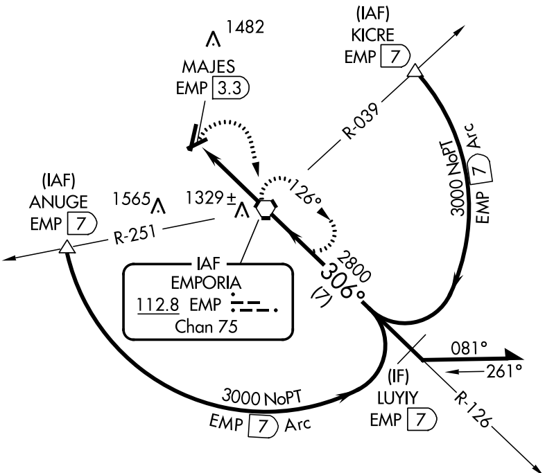
First, I forgot to mention a couple of other things that Peter and I discussed in the day 2 classroom sessions. We talked about IFR currency rules (remember, kids, 6 6 HIT), as well as the procedures to be used if you lose radio contact with ATC. The most interesting topic to me was the discussion of DME arcs on approaches, like the one shown below:

See that arc? It's called a DME arc. Want to know why? Read on.

See that arc? It’s called a DME arc. Want to know why? Read on.

This is the VOR/DME-A approach to Emporia, Kansas.  Depending on where you are when you join the approach, several different things can happen. If you’re approaching from the southeast, you’ll probably get cleared straight to LUYIY, and you can just fly the approach inbound. If you’re coming from the west side of the airport, you might get sent to the triangle labeled ANUGE (those triangles mark intersections, imaginary points in space that you use for navigation); from the northeast or east, you’d probably go to KICRE. In those latter two cases, you’d fly a constant-distance arc from the intersection to the final approach course. They’re called DME arcs because originally they required you to have a special navigation receiver known as distance measuring equipment. Now you can use GPS instead, unless you happen to have a DME receiver. To fly these approaches, you basically fly to the intersection, fly a distance, turn 10 degrees towards the center of the arc, and fly another distance. Think of it like making a circle out of straight lines. (There’s a decent explanatory video here if you’re interested in more detail).

Anyway, on to day 3’s work. Since we’d finished day 2 in the classroom, day 3’s morning was spent in the airplane. We took off from Manhattan and flew to Marysville (where we shot the GPS 16  approach) and then on to Plattsmouth, Nebraska: my first time to visit the Cornhusker State. I flew the GPS 34 approach, but not until Omaha Approach vectored me all over the place to accommodate some KC-135s working the traffic pattern at Offutt AFB. After landing, we borrowed a crew car and went to– no joke– Mom’s Cafe, where I had a chicken-fried steak about the size of my laptop screen. In fact, it was so big that I couldn’t eat the whole thing and declined the offered dessert.

After fueling the plane, it was off to Beatrice (pronounced “BEE-at-riss”), where I flew an approach– can’t for the life of me remember which one though; then we flew back to Manhattan, shot another GPS approach, and spent some time in the sim practicing ILS and VOR approaches into Topeka. Why Topeka? Tune in tomorrow to find out…


2 Comments

Filed under aviation

GATTS day 2: ILS and VOR approaches

Day 2 was a busy day– by this point, I was settled into the apartment and was able to navigate around through Manhattan fairly well. We spent the morning in the classroom talking about various types of approaches, primarily ILS and VOR approaches.

There are two basic types of instrument approaches: precision and non-precision. The method of navigation for the approach determines how precise an approach you can fly. Some approaches give you guidance on whether you’re left or right of the runway centerline (lateral guidance), but you have to figure out your own vertical position. Others give you both lateral and vertical guidance. For example, an LNAV approach gives lateral guidance but no vertical guidance, while an ILS approach gives lateral and vertical guidance. A precision approach is one where vertical guidance is provided by a ground reference, e.g. the glideslope signal transmitted by an ILS. A non-precision approach can still include vertical guidance, but it’s either calculated or measured by something aboard the airplane. For example, my onboard GPS can use barometric pressure differences to calculate the current altitude, and it knows where the airplane is along the approach course. The diagram for each approach includes a profile view that shows what your vertical profile should look like on approach, such as this profile from the ILS to runway 17 at the Montpelier, Vermont airport:

The underline beneath those numbers has a simple meaning: don't go lower than that altitude or you might die.

The underline beneath those numbers has a simple meaning: don’t go lower than that altitude at that point in the approach or you might die.

Let’s say that the GPS sees I am between the REGGI and JIPDO waypoints. It knows that I can descend a maximum of 600′ between the two. By using either GPS altitude data (VNAV) or altitude data derived from the current altimeter setting (Baro-VNAV), it can give me a visual indication of how much I should climb or descend to follow a smooth path along the approach course.

After all that, it was time to go flying in the ancient simulator. This particular sim doesn’t have a GPS but that wasn’t a problem given what we were doing. I (mostly) tamed the roll axis sensitivity and flew pretty well; we flew a couple of approaches and then took a break for lunch at a nearby Mexican place, thence to the airport. Our planned route was pretty interesting: Manhattan-Salina-Newton-Emporia-Manhattan. It makes a pretty square, as you can see below:

Kansas is square. So was our route.

Kansas is square. So was our route.

We flew one approach at each airport; I forgot to note exactly which ones, but I’d guess (based on the approach plate history in my iPad)  the ILS 35 at Salina, the VOR/DME-A at Newton, and one of the GPS approaches at Emporia, plus the GPS at Manhattan. 3 in the sim and 2.6 PIC in the airplane made for another fun-filled day!

1 Comment

Filed under aviation

Database debacle: why aviation GPS systems are different

tl;dr: We’ve all been spoiled, and it’s Google’s fault.

All right, maybe it’s not entirely their fault (though I do love a good Google-bashing session), but the widespread availability of Google Maps put incredible price pressure on vendors of mapping data to drop their prices. That pressure led to today’s bounty of mapping applications: Google, Microsoft, and Apple offer high-quality map data on their mobile and desktop operating systems, and there is a huge number of applications that take advantage of this data and mash it up in interesting ways. Most of the major vendors of portable GPS devices quit charging for map data, given that their competition– smartphones– have instant map updates anytime, anywhere.

Sadly, this revolution in cheap, broadly available map data has largely bypassed the aviation world. In part that’s because the number of data sources are small; in the US, you can get approved digital chart data for aviation use from the US government or from a small number of private providers, many of whom take the government data and format it in various ways for specific applications or devices. The approach plates, sectional charts, and other maps that pilots depend on for planning and flying are generally not free (though, in fairness, some sites, such as SkyVector, make lots of data available for free).

If you have a panel-mounted or handheld GPS that’s certified for aviation use, you’ll be paying for regular database updates, one way or another.

This is true for two reasons. The first is that data quality is super important. Things change all the time: people put up new towers, airports open or close, the FAA changes routes to accommodate changes in air traffic patterns, and so on. If your car GPS doesn’t show the street you’re on, no biggie: you’re still on it, and there are probably signs. At worst, you can stop and ask for directions. On the other hand, if your airplane GPS doesn’t include a newly added TV tower along your route of flight, you may be in for a very unpleasant surprise.

The other reason is that the FAA requires you to use only certified and up-to-date data sources for navigation. You may use some data providers or devices for “reference” or “advisory” use, but you can’t depend on them as the sole source of navigation data. For example, the excellent Foreflight app for iOS has charts that display your aircraft’s position (known as “georeferenced” charts), which provides great situational awareness. For $149/year, you get full access to all the visual and instrument navigation charts for US airspace. But the FAA won’t let you use the iPad as a primary navigational instrument for instrument flight. For that, you need an IFR-certified GPS, and those have strict requirements for data quality and timeliness.

As part of my instrument flight course at GATTS, I’ve been learning to use the Bendix/King KLN94 navigator in my airplane. The KLN94 first shipped in (drum roll) 1991. Think about that for a second: I am flying with a GPS system that dates back to the First Gulf War. That said, it’s pretty capable; it can navigate me through almost all the different types of instrument approaches, and its user interface, while clunky, is not that much worse than the very popular Garmin 430/530 that followed it. (For an example of flying the KLN94, see this video.)  When Derek and I bought the plane, I knew the KLN94 database was out of date, but the owner gave us a Compact Flash card with a map update. (Note: yes, I said “Compact Flash.” Remember those? If so, then you are officially old.)

Today I got ready to install the database update on that card.. only to find that it was valid for 1-28 May of this year. That’s right; the whole card had one lousy month of map data on it.. data that was 3 months out of date. Showing up for my checkride with an outdated database in my GPS would lead to instant failure. But I found out about this about 215p on the Friday before a holiday weekend. I won’t say I peed a little, but I was getting unsettled at the prospect of hosing my checkride schedule. As soon as we landed, I called Bendix/King’s “Wingman” service number.. and got their answering machine. Uh oh.

At this point, I was trying to figure out how long it would take me to drive to Olathe, Kansas (not long) to pick up a new database card. Maybe I could lurk outside the Bendix building like a ticket scalper! Or I could hand-write a cardboard sign: “NEED KLN94 UPDATES PLEASE HELP”.

You might be wondering why I didn’t just download a new database update from Bendix/King’s web site. Fair question. See, there’s another problem with aircraft GPS systems. They often have ridiculous systems for providing data updates. KLN94 database updates can be downloaded from Bendix/King’s web site, but the only supported device for loading the databases is a single model of SanDisk CompactFlash card reader or you need a special cable to use it and the software to use that cable only works on Windows 95. Oh, that one card reader? It needs a firmware update, which requires a machine running Win95 to install. Other systems have their own failings, so I’m not picking on Bendix/King, but sheesh.

A second call to their tech support number got me a super helpful gentleman named Shane. He confirmed that only the Holy SanDisk could be used to load database updates, but he passed me over to Lorie, one of the folks in the database update department. She listened patiently to my explanation, refrained from saying how stupid I was to put off the update, and told me the solution: “Go to our web site, order the card, and I’ll make sure you get it tomorrow.” Whew, that seemed simple enough. I went to the web site, created an account, and found the KLN94 updates. For the low, low price of only $280, I could get a new CompactFlash card with data valid from 21 August to 18 September.

That’s right.

$280.

I ordered it anyway.

It will be here tomorrow. Then I can update my GPS and pass my checkride. After that, I will expedite installing a GPS system that has a lower ongoing maintenance cost. (In fairness, it’s only $120 to download a single month, and there are deep discounts for subscriptions, but I hope not to have the KLN94 long enough to make a subscription worthwhile.)

So, hats off to Shane and Lorie for their help; thanks to Bendix/King for continuing to support a 24-year-old GPS system, and shame on me for waiting until the last minute to check my database. Bet your boots that won’t happen again.

Leave a comment

Filed under aviation

GATTS day 1: holds and approaches

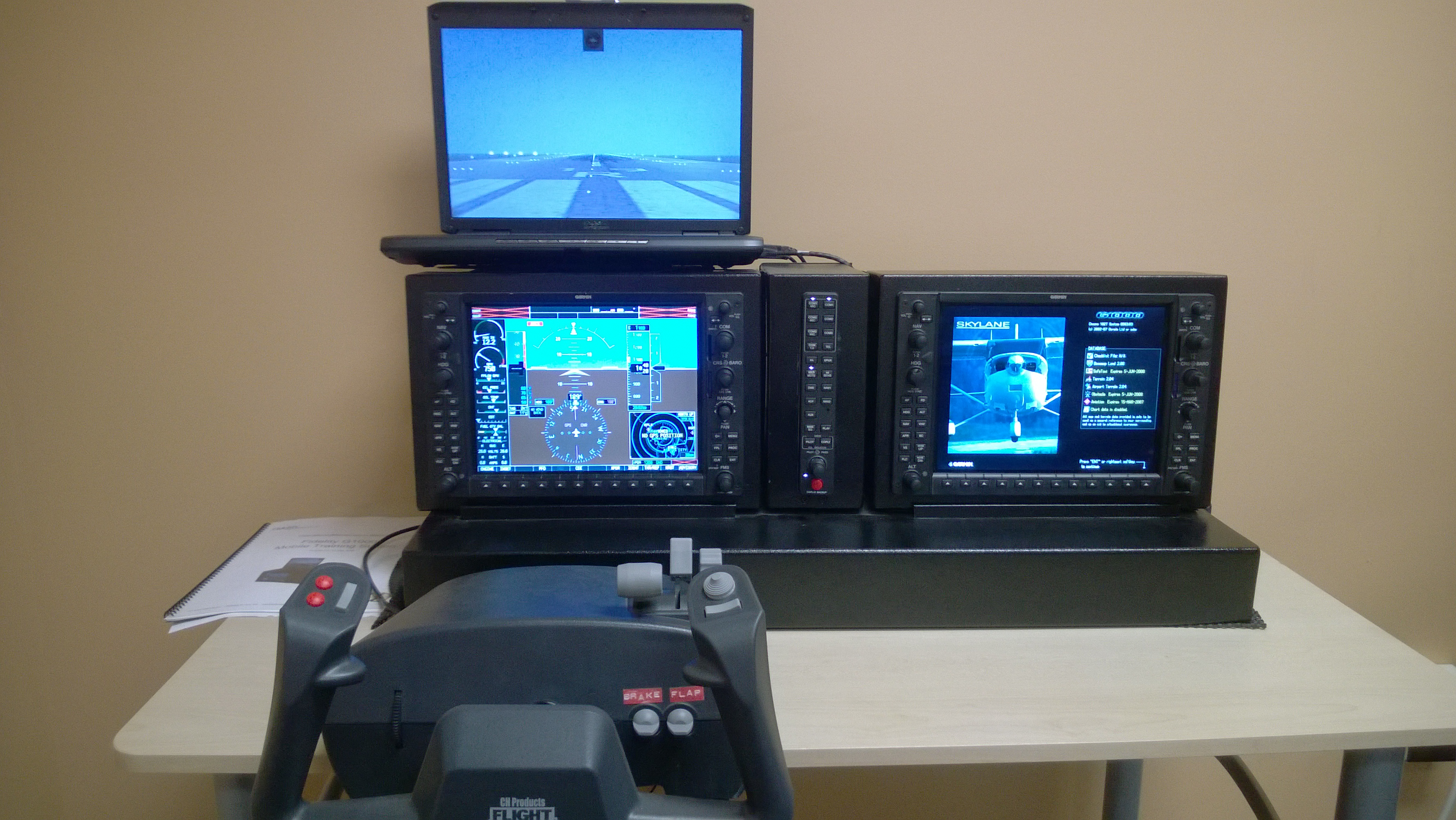
My first real day of GATTS started bright and early Tuesday morning. I met Peter at the GATTS classroom facility, which is in a nice office park adjacent to a sports bar and some medical offices. When you walk in, here’s what you see:

WP_20140828_003

Sadly, that wasn’t the simulator that Peter and I were scheduled to use, but more on that later. We adjourned to a small classroom and proceeded to dive into that day’s classroom curriculum. Because GATTS requires its students to pass the written exam before they show up, this was more a review of practical issues surrounding the topics we covered than a tabula rasa introduction. The GATTS class is structured in a fairly standard triad: first you discuss a topic with the instructor, then you do it in the simulator, then you do it in the airplane. These three things may take place on the same day, or they may not. I picked up a few tricks for holds, including what they teach as the “GATTS entry”. Instead of worrying about parallel vs teardrop vs direct, they preach a simpler rule: if you’re coming from the “long” side of the hold, go direct, and if you’re not, fly to the fix, fly 1nm past it, then turn 45 degrees opposite the turn direction for 2nm, then start your procedure turn. For example, let’s say you’re going to fly the published hold at DCU:

The DCU VOR 274 degree hold is that little racetrack-looking thing

The DCU VOR 274 degree hold is that little racetrack-looking thing

If you’re west of the Decatur VOR, just fly until you intercept it; that’s easy. If you’re east, fly to it, fly past it, then turn from 274 degrees to 219 degrees, fly for 2nm, and then do your standard-rate procedure turn– you’ll magically end up about 3nm from the VOR on a heading of 94 degrees. (Try it if you don’t believe me). I was always taught to fly timed legs in a hold, so doing it with DME distance was quite a revelation, and it’s much easierI flew that hold a few times in the simulator, along with a couple of other ones, then we reviewed and flew a few simulated approaches. About the simulator: Flight Simulator 2000 on an ancient Dell running Windows 95. Yep, old school. It shares the common PCATD simulator trait of being super sensitive in the roll axis, so you fly it like you do an A320: put in the amount of roll you want, then take it back out again. Neutralizing the controls in a turn does, basically, nothing; you have to apply an equal amount of opposite aileron to get where you want.

Anyway, I did a decent job in the simulator (flying a total of 4 approaches for 3.3 hours), so we headed out to the airport to go do some bidness. We flew approaches at Abilene (the VOR-DME A), Herington (the GPS 17), and Manhattan (the GPS runway 21, if I remember right) approaches, netting a total of 1.9 PIC hours for the 4 approaches. Sadly I only got 0.1 actual on this outing, but I did learn a great deal about how to coax the ancient KLN94 in the airplane into doing what I want.

The mental effort of learning all this stuff took its toll in the evening; after we put the plane to bed, I went to the grocery store, loaded up on food, then went back to the apartment and did absolutely nothing productive for the rest of the night. It took a while for all that learning to sink in, I guess!

Leave a comment

Filed under aviation

GATTS day 0: Huntsville to Manhattan

In my last flying post, I explained why I was going to GATTS to get my instrument rating. For the next few posts, I’ll be chronicling my experiences there.

One of the things that appealed to me about GATTS was that you have the option to use your own airplane. Another is that they assign a single instructor to work with each student for the entire course, and (for a modest fee) they’d send the instructor down a day early to ferry the plane back. I wanted to take advantage of that option for two reasons: in case the weather were bad my arrival in Kansas wouldn’t be delayed, and I could use the extra flight time to get a head start on my classwork. I signed up for the ferry option, and, as planned, my instructor, a cheerful fellow named Peter Schmoling, showed up Sunday afternoon. The boys and I took him to dinner to get acquainted, and then Monday morning I picked him up at his hotel and we headed to DCU to start our trip.

We had planned to fly from Decatur to Kennett Memorial in Missouri, thence to Manhattan, Kansas, where GATTS is located. This plan went off without a hitch. I don’t have much to say about the actual flight except that I hand-flew both legs and logged a bunch of simulated instrument time while doing it. It was pretty smooth.

We found that the Kennett airport had a nest of fast food places right near the arrival end of runway 18, so we walked over to McDonald’s and had lunch. After refueling, I got to practice my hot-start techniques. The POH calls for a hot start procedure that’s identical to the cold start, minus priming. After doing some Internet research, I found that the consensus seems to be that the best procedure is to leave the electric fuel pump off, set the throttle to full, mixture to idle, and then start the engine. It took a couple of tries, but this procedure worked and we were off to Manhattan. Our flight was completely uneventful except that we had a controller out of Kansas City Center who sounded just like Cleveland Brown. I took the ILS approach for runway 3, landed, and taxied to the hangar that GATTS provides– it was a tight fit, but with Peter’s help I got the plane in without bending anything.

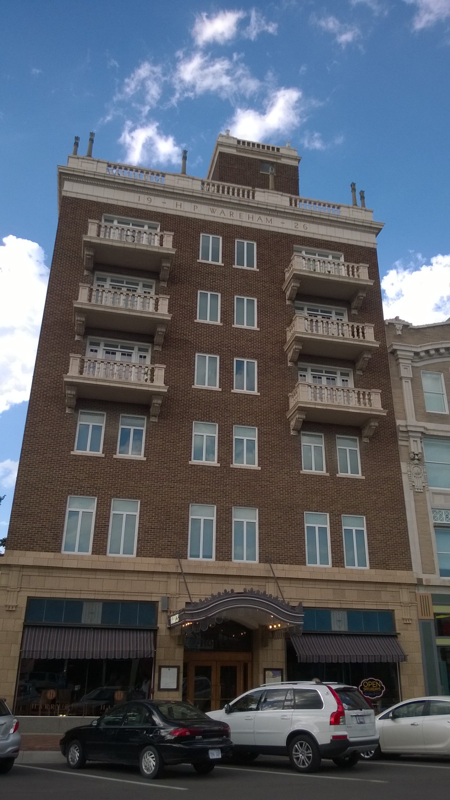
GATTS includes housing and a car in the course fee. My car was a late-90s Taurus with great air conditioning– the only thing I was really interested in at that point. After handing over a map and the car keys, Peter took off and I drove downtown to my apartment building, which sits over a swanky restaurant named Harry’s. The apartment itself is basic, but nice: a small kitchen (two toasters but no dishwasher), a comfy double bed, a dinette, and a living room with a balcony overlooking the street below. It sort of reminds me of a timeshare beach condo: it has all the necessities but nothing fancy. GATTS maintains 3 apartments in the building for students, and previous occupants had left a small collection of airplane magazines, books, and movies around.

I unpacked, plugged in all my gadgets, and set out to explore.

My nifty apartment building

My nifty apartment building

Right up the street is Manhattan Town Center, a smallish indoor mall. I walked a lap there just to see what was on offer (answer: nothing I wanted except an iPad charging cord, since I’d forgotten mine). I’d spotted several restaurants during my short walk; the closest was Hibachi Hut, which I’d ignored because of the name. When I looked on Yelp, though, I saw that they a) served Cajun food and b) had great ratings, so I went there for dinner and had an excellent shrimp and crab bisque and a dish of andouille and chicken pasta. Friendly, quick service, great cornbread, and a nice selection of local beers made it a very pleasant meal.

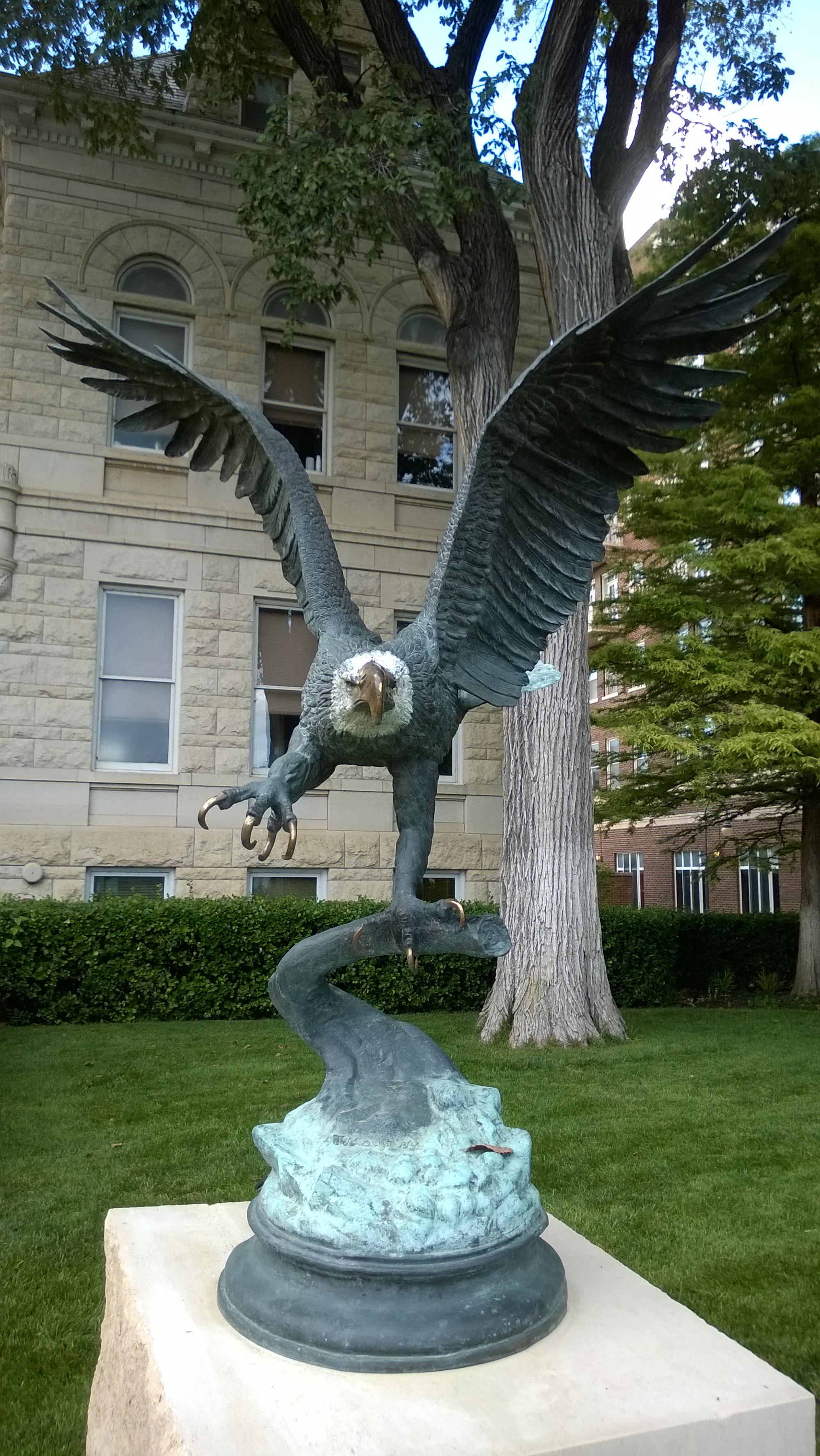
Then I decided to explore a bit more; my apartment is right next to the Riley County Courthouse, and further down Poyntz Street is Manhattan City Park. I didn’t make it to the park my first day, but the courthouse has this excellent statue as part of a small courtyard dedicated to American veterans.

Because AMERICA.

Because AMERICA.

By this point I was pretty tired, so I hit the bed. Day totals: 4.8 hours PIC time, 0.5 actual instrument, 4.4 simulated instrument, and 2 approaches. All in all, a great way to start the week!

1 Comment

Filed under aviation

Rocketman 2014: my epic fail

In idle conversation with my friend and fellow TRI101 attendee Alex, we started kicking around the idea of forming a relay team to do the Rocketman Olympic-distance triathlon. The Olympic distance is the next step up from sprints; it combines a 1500m swim, a 40Km bike ride, and a 10Km run. I figured I could do either the bike or run, but not both back-to-back, and I knew I didn’t want to attempt the swim… but Alex is a strong swimmer and he jumped at the chance. We recruited Ryan, another TRI101 member who runs ultradistance races, and we were all set.

In the weeks leading up to the Huntsville Sprint, I’d been thinking about buying a new bike. Instead of splurging I decided to rent one from Madison Cycles and give it a try for this race. I picked it up on Wednesday, but didn’t get to ride it until Friday, at which point it scared me badly! At nearly 10lbs lighter than my normal ride, and with much narrower tires, different geometry, and different gearing, it felt much less stable, and after my first ride my shoulders ached from gripping the handlebars so hard. On Saturday I rode it again and felt a lot better, though. I packed my stuff, attended the race brief with Alex and Ryan, and got to bed at a reasonable time. Sunday morning found me up at 0430 to finish my last-minute prep and drive out to the Arsenal’s recreation area, which abuts the Tennessee River. I’d signed up for a volunteer shift at the packet pickup booth, where I had a grand time visiting with friends and helping triathletes get their packets and swag for the race. The morning was cool and overcast, and as dawn broke I was excited about the race.

I met Alex and Ryan at the transition area, got everything set up, and headed over to the swim area. In a relay race, the swimmer starts with the timing chip and hands it to the cyclist in T1,  then the cyclist hands off to the runner in T2. Rocketman has a separate transition area for teams, which is handy.  Once Alex started the swim, Ryan and I hung out in the transition area until he came out, then I was out the chute and on the bike. By this time it had warmed up a bit, but it wasn’t too bad, and I felt great. Fresh breeze! Beautiful scenery! I’d violated my normal “nothing new on race day” rule and was sporting a Camelbak for hydration; I figured it, along with two water bottles on the bike, would keep me well hydrated.

The first mile of the course went by smoothly and quickly. I was keeping an eye on my pace because 40Km was about a third farther than my previous longest ride, and about half again as long as my previous longest race, but I was still feeling great as I rounded the turn near mile 2… and then suddenly it seemed like the bike was slowing down. I pedaled faster. This had no effect other than to rock me back and forth in the saddle. “Maybe I need to shift some more,” I thought. So I did, fiddling with the bike’s four shift levers in a fruitless effort to stop decelerating. Finally I had to unclip and pull over, where after some experimentation I found that the freewheel gear inside the rear hub had broken or something. Pedaling turned the crank, which moved the chain, which turned the rear cassette, which did nothing to the back wheel. I fiddled with it for another 10 minutes or so, to no avail; then I reluctantly turned the bike right side up and started the Walk of Shame back to the corral.

Along the way, I am happy to say, probably 4 out of 5 cyclists who passed by me asked me if I was OK. I appreciated their support a great deal, though they were moving too fast for me to do more than shout “THANKS!” at their rapidly receding backs. At one intersection, world-famous race photographer Gregg Gelmis was set up and captured the moment:

Me after my rental bike crapped out during Rocketman 2014

Me after my rental bike crapped out during Rocketman 2014

Thanks to my distinctive jersey (which I love, so shut up, haters), Alex and Ryan could see me before I made it back into the corral and they knew something was wrong. I am very grateful to them for how gracious they were; the mechanical failure of my bike meant that I officially did not finish (DNF’d) and so our team was marked as DNF’ing. Ryan ran the 10Km leg anyway and turned in an excellent time; while he was killing it in the 90-degree sun, Alex and I got to cheer a number of our TRI101 friends and coaches as they crossed the finish line. (Results are here if you want to see how fast everyone was.)

The Madison Cycles folks were very apologetic, and I’m sure they’ll settle up with me when I get back home. Mechanical issues happen. as anyone who’s owned any device more complex than a pencil knows well, so I don’t blame them, but it was still frustrated because I was excited to compete. I still had a great time; I especially enjoy the social aspect of triathlons because, while it’s a very competitive sport, the competitors tend to be very friendly and incredibly supportive. It’s a sport where you can take genuine pleasure in the successes of your friends, which suits me just fine.

The only thing to do: come back next year and DO THE WHOLE RACE. That will show ’em.

3 Comments

Filed under FAIL, Fitness

Getting geared up for GATTS

So far, since Derek and I bought 706, I’ve logged just over 45 hours flying it. Solo, I’ve gone to Louisiana and Vermont; the boys and I have gone to Pigeon Forge, Demopolis, Atlanta, Anniston, and Tuscaloosa. Now it’s time to step my game up a notch: on Monday, I’m flying to Manhattan, Kansas, for a week of accelerated instrument training with GATTS. A few of the folks I’ve talked to (including family members and coworkers) have asked lots of good questions about this plan, so I thought a quick Q&A might be in order.

Q: What’s an instrument rating?
A: With an instrument rating, you can fly under what the FAA calls “instrument flight rules.” Basically, you can fly in and around clouds, fog, and rain, or in conditions of poor visibility– all by using only the instruments in your cockpit, without being able to see any landmarks or the horizon.

Q: So you can fly in bad weather!
A: Nope. An instrument rating allows you to take off, fly, and land under certain conditions. For example, to legally land at Huntsville’s airport, you must have at least a 200′ ceiling and 1/2 mile visibility. That doesn’t mean it would be safe to do so, just that if the weather is worse than that, you can’t land there. It’s not a license to fly in thunderstorms, blizzards, high winds, and the like, although each year a few people die from confusing “legal” and “safe” and taking off or flying through visible or embedded thunderstorms.

Q: Then why bother?
A: Think of a typical summer day in the South: partly cloudy in the morning, building thunderstorms in the mid-afternoon, then partly cloudy again in the evening. With an instrument rating, you can (legally and safely) penetrate the clouds, fly on top of them, then descend and land lately. You also get guaranteed routing and safety services from air traffic control, whereas when you fly visually those services are available on a best-effort basis.

Q: Kansas? Couldn’t you find a local instructor?
A: I love my instructors here in Huntsville. (Hi, John! Hi, Caroline!) But the big advantage of the GATTS program is that you spend the entire time flying. When I got my private license, my training dragged out because I had to line up 4 factors: my schedule, my instructor’s schedule, the airplane’s schedule, and the weather. By blocking out the time as one chunk, I should be able to build my skills much faster. Kansas is different enough from here that I will have to master the skills of navigation and approach management (in other words, I can’t depend on my knowledge of the local Huntsville area), but it doesn’t have a lot of demanding terrain or complex airspace.

Q: Is it like boot camp, then?
A: Wow, I hope not. There was a lot of yelling when I was in boot camp, for one thing. GATTS says their typical day is from about 830a to 6p. During that time, I’ll be in the classroom with my instructor, flying in the simulator, or flying my airplane. Oh, and eating lunch. The schedule varies from day to day, depending on what we’re working on. We’ll do this every day– weekends and Labor Day included– so that I get the most out of the time. I’ve already been able to carve out time for a few scheduled webcasts and conference calls that I couldn’t move.

Q: Is it expensive?
A: The answer to this question is always “yes” when it comes to aviation.

Q: No, really.
A: Yes, really. If you factor in just the instructor’s time alone, GATTS is more expensive. However, there’s no way on earth that I could get a local instructor to fly with me day in, day out long enough to learn what I need to know. Then I’d end up having to repeat lessons to knock the rust off. The GATTS program also includes lodging in Manhattan and a car to use. Plus, I’ve never been to Kansas.

Q: Why an accelerated program?
A: The best way to get proficient at flying is to fly. The best way to get, and keep, instrument proficiency is to compress your training, then use your instrument privileges regularly. I’ve already had to delay or change travel plans many times to account for vagaries of weather; being instrument-qualified doesn’t eliminate that (hello, thunderstorms!) but it gives me many more options. Ultimately, the airplane is a time machine: it lets me travel to places, and in time windows, where I otherwise couldn’t, so having the ability to fly in weather is really important to me. I want to do it as safely and proficiently as possible.

I’m planning, time and energy level permitting, to keep a daily journal of my experience at GATTS. Stay tuned…

Leave a comment

Filed under aviation

In which I become a repeat offender

Yesterday marked a milestone: my second triathlon, the Tarpon Tri in Houma, Louisiana. I was fooling around one day on TriFind and noticed that there was a race there, so I signed up– I thought it would be a fun trip to see family and visit my hometown again. But you know what they say: one triathlon and you can explain it away as harmless experimentation, or perhaps a temporary indiscretion… run TWO, though, and you’re a repeat offender, well on your way to “serial triathlete” status.

I’d planned to make the 359nm flight from Decatur to Houma on Friday afternoon, so after a great conference call with a potential new customer (more on that next week, I hope), I loaded up the plane. With the two rear seats removed, it was easy to fit my giant road bike, my tri bag, and backpack in; I parked the car and off I went. I’d like to say a lot of neat stuff about how interesting the flight was, but the fact is that it went flawlessly: no major weather, a smooth ride, and some really interesting scenery, including a beautiful crossing of Lake Ponchartrain right alongside the Causeway. After an easy landing, I headed to my hotel to drop off my stuff, plug in all my gadgets, and make plans to see family.

(Side note: I cannot possibly say enough good things about how well the folks at Butler Aviation took care of me. When I arrived, they had a rental vehicle ready because I’d emailed ahead– no mean feat since the nearest rental agency is 10 mi or so away.  When I got ready to come home, the plane was fueled and ready to go, and everyone there was super friendly. Highly recommended.)

Dinner Friday night was excellent: my Aunt Norma, my cousin Ricky, and his wife Tonya went to Dave’s Cajun Kitchen. The name gives it away, of course: it’s Cajun food, but the kind that people actually eat. Gumbo, fried catfish, white and red beans, jambalaya, and so on. I have never had a meal there that was less than excellent. This one was so good that I ate more than I should have, for which I would pay later.

After a visit back to Ricky’s, I headed to the hotel, got my gear ready for the morning, and went to sleep… then spent all night having reflux-y burps of white beans and catfish. Key learning #1: don’t eat so damn much before the next race.

Saturday morning I got up, hit Walgreen’s for some Tums, and headed to the race site for packet pickup. The place was packed! I should’ve gone to get my packet Friday night; after 20 minutes or so in line, I got my packet and chip, got body marked, and headed to set up in transition. Thanks to all the practice with the TRI101 coaches, I had no trouble getting my gear laid out, so I headed to the pool to get in a quick warmup.

This race had staggered pool starts: the fastest swim time was #1, the second-fastest was #2, and so on. If you didn’t put down a swim time, as I didn’t, you went to the back… so I ended up being #180, meaning that I had about a 35-minute wait to get in the water. Key learning #2: put down the right swim time. I had a very pleasant time visiting with the triathletes in line near me, including a multiple half-Ironman finisher and a guy who was running his first race to celebrate his birthday weekend (he didn’t say what birthday but he was no spring chicken!)

The swim went well– 150 yd in the pool in 3:57. Oddly, Movescount showed me with 125 yds (how? it gets its data from my watch, which showed 150 yds!), and the official time for the swim was 4:36:37. The info packet said:

The timing chips are all pre-set as to when they begin your time according to the seeding chart that we give to the timing guy. Please pay attention & listen to the volunteers who are starting you. They have a list of what time each participant is to start his/her swim.

That makes me wonder if for some reason the swim times were off based on the expected time at which I was supposed to get in the water. In any event, the swim felt good. I got through T1 in a leisurely 3 minutes, partly due to my decision to try my new USMC cycling jersey as racewear. Turns out putting on a clingy bike jersey when wet is really hard– and it reminds me of key learning #3: nothing new on race day. (For reference, the fastest T1 time in my age group was 19.9 seconds!) I also forgot to grab my race belt, which turned out to be OK because we were issued number stickers for our helmet, though at first I had paranoid visions of being DQ’d for not having a visible number.

The bike course was great: flat, hot, and sweaty, just like my first girlfriend. We got a steady light rain for about the first 25 minutes I was on the bike, so the pavement was a little damp but not unmanageable. The course runs right along the bayou, so there was lotsto see: egrets, various other birds, cypress trees, and the whole nine yards. There were plenty of volunteers along the course, great course markings on the pavement, and very little traffic. I averaged 15.6mph on the bike course, for a time of 38:28, which was a little frustrating because I thought I’d be faster. I didn’t take the time to mount my Suunto on the handlebars during transition, though, so I couldn’t easily see my cadence or pace. Next race I think I’ll mount the watch during setup and just go without in the pool.

Coming back in from the bike, I got through T2 in 1:02, then headed out for the run, which was also flat. The sun was powering through the clouds by this time, giving runners the sensation of being tucked snugly in Satan’s armpit. Luckily, the organizers had planned for this: there was a water station at the half-mile mark, then again at the turnaround. I spotted a roadside portatunity (that’s a porta-potty for those of you who don’t speak the lingo) and made an emergency diversion, then got back to it. I spent a few stretch breaks walking– more than I wanted to– but still finished the run in 31:51. During the run I noticed some pain on my chest; afterwards I found about a 1/4″ cut on my nipple! I have no idea how it got there, but I bet it was because of the new jersey and/or not using BodyGlide under my HRM strap. Ouch. Key learning #4: you can never have too much BodyGlide.

Overall, I came in 13th in my age group and 96th overall, with a total time of 1:19:00.2. I would have needed to pick up about 2min to move up to the next place. My goals were to finish and to be in the top half, so I was pretty pleased. Swag-wise, I got a nifty tech shirt, a coffee mug, and a can coozie, all of which I can add to my collection.

After the race, I took Ricky and his son Seth for a sightseeing flight. The ceilings at HUM were only about 3500′ and it was drizzling, but we did a couple laps around the pattern and overflew Gulf Island Fabrication, where Ricky works. This might have been the high point of the trip, because the two of them were so clearly enjoying it. I wanted to beat the weather heading north, so after I dropped them off I immediately took off to the north. There was heavy weather directly over the New Orleans airport, which I would have overflown, so I ended up diverting well to the west to get around it. As I worked my way further north, the ADS-B weather from my Stratus showed that there were storms all along my route from about Tuscaloosa north, so I landed at Demopolis to refuel and take a short break. After that, it was a simple matter to dodge a bit (as you can see below) by flying from Demopolis towards Courtland, then turning east once past the storms. Note that the magenta line shows the GPS track, not where I actually was; I had flown well to the west to clear the tail of the storm (the red blocks near the “6nm” label).

20140802_232620000_iOSKey learning #5: datalink weather is strategic, not tactical. It isn’t updated in real-time, so you can’t use it to thread through closely spaced storm cells. The weather was gorgeous when I got to Decatur, so I landed easily, put the plane away, and headed home– with another triathlon and another 7 or so flight hours under my belt. All in all, a great trip, even if I am on my way to a life of crime triathlons.
Leave a comment

Filed under aviation, Fitness

Training Tuesday: it’s all about finesse

[note: I meant to post this after TRI101 yesterday but got sidetracked with RAGE, for reasons which I’ll explain shortly.]

I’ve been super busy since my last Training Tuesday post with a variety of projects (new job means finishing up the old job’s work!), so I skipped a couple of weeks. I did, however, join Strava, so if you’re on there feel free to follow me.

TRI101 has continued to rock right along. Two weeks ago we did a timed mile (8:08, a new PR for me) plus about 2.5 miles worth of hill work; last week we did two 2-mile runs at Indian Creek, with some core work in between, and tonight we did a brick. I finally got back into the pool and am slowly cranking up my distance. You don’t get a lot of training benefit from just swimming super long distances without stopping; instead, the best advice I’ve seen is that you should swim for whatever the total time you expect in the race is. For example, if you swim 400m in 8 minutes, and you’re getting ready to swim a 1500m race, swim at least 3×400 with short rests and you’re good to go. I’m trying to work up to swimming 1000m in one session, even with rest breaks. That will cover me for any of the sprint-distance events I’m doing this year or next, and will give me a solid base for next season if I move up to Olympic distance races, which feature a 1500m swim.

My friend Rachel loaned me her Garmin heart rate strap, which, when paired with my Ambit 2s, gives me a good idea of how hard I’m working. It turns out that at my normal pace of between 8 and 8:30/mi, I am working pretty dang hard; my heart rate runs in the 140-160bpm zone. For my age, that’s nearly max effort. Interestingly, I don’t work nearly as hard on the bike as I do in the run. I think that means I’ve got a lot of potential speed improvement ahead on the bike if I can get my legs to cooperate; my cardio isn’t the limiting factor there. I think I’ve mastered the trick of getting the Ambit to correctly measure pool swims, too (you need a hard push off the wall when turning), so all my remaining races and training will hopefully be logged correctly.

NewImage

Maximal effort for great justice

Right now I’ve got two more races coming up: one in Houma week after next, then the Huntsville Sprint two weeks later. At this point I don’t feel like I have a lot of new stuff to learn; instead, I am trying to polish what I do know and focus on my technique. For example, my swim technique still needs some fine tuning; that’s still my biggest weak point, although the more I swim, the more confident I feel about it. The only way to get good at swimming is to swim, of course. On runs, I’m working in fartleks for speed. On the bike, I’m still working on not falling over when I unclip.

Although I’ve been trying not to make any more equipment changes, I finally got around to doing something I’d been planning for a while: I put road tires on my bike. Those of you who have seen my giant bike know that it had big knobby hybrid trail/road tires on it. I pulled those and put on a pair of Continental 28s. At yesterday’s workout I was killing it on the bike— my speed on the route (a loop around the Arsenal) was a good 3-4mph higher than normal, with no more effort expended. I felt great, right up until I dismounted and tried to switch my watch into transition without looking… resulting in erasing my workout altogether. I was roughly keeping pace with my pal Alex, so I know it was about 11.2 mi in just over 44 minutes, but I lost all the pace and HR data. By the time I got home, I was so mad that I didn’t feel like finishing this post, thus its appearance on Wednesday.

(The good news about the delay in posting is that I can sum up today’s swim lesson with Lisi: enlightening. Unlike running or riding, where my form is pretty natural and just needs a few tweaks, my swim form is poorly developed. It’s improving, for sure, but there are lots of little tweaks that Lisi has been able to point out. After my last session with her a few weeks ago, I’ve felt more at ease in the pool so I’m looking forward to working on the 3 things she identified for me today: earlier head rotation when breathing on the right, keeping my hips lower in the water, and being sure to get my full extension before I start the pull. She’s also given me some new drills and workouts that I will do twice a week; I think they’ll make a big difference.)

I’ve been trying to rest my left Achilles tendon a bit, so I skipped my regular long run last week and have been icing it at night. I think it’s about back to normal, so this week I’ll hit my long run, at least one long ride, and another swim or two. It didn’t bother me at all yesterday, though it was a bit tender after the bike/run brick last night.

What will all this polishing and tweaking lead to? There are a bunch of upcoming races in various places, and at various distances, so I’ll probably continue doing sprints until the end of the season and work in at least one 10K. It’s not too early for me to start thinking of what races I want to run next year, too. I found this article to be super helpful; this year I didn’t really have an A race, but I need to pick one for next year: probably an Olympic. I love poking around on trifind.com and looking at all the races, so this will be a lot of fun.

Fun note: I like to try to work races into my training schedule, so last weekend I flew up to Providence and ran the Craft Brew 5K with Julie and her friend Sigrid. This was a fun race, with a large emphasis on post-race beer drinking as opposed to record-smashing running. Despite that, I turned in a smoking time, at least for me: 2.9mi in 25:22, an 8:42 pace. The race chip time scored me at 25:18 and gave me an 8:08 pace, so I am thinking that the last-minute change to the race course shortened it a bit. The post-race beer tasting was fun, although the quality varied quite a bit. My favorite was Dragon’s Milk Bourbon Barrel Stout, for what that’s worth; I may have to lay in a post-race supply!

Leave a comment

Filed under Fitness

Moving to Summit 7 Systems

It must be the season or something. Like several of my peers (e.g. Paul, Phoummala, and Michael, to name 3), I’m moving on from my current position to a unique new challenge. In my case, I’m taking the role of Principal Architect at Summit 7 Systems.

Astute readers may remember that, just about a year ago, I joined Dell’s global services organization as a global principal consultant. I was fortunate to work with a large group of extremely smart and talented people, including several MCMs (Todd, Dave, Andrew, Ron, and Alessandro, y’all know who I’m talking about!) Working for a large company has both its benefits and challenges, but I was happy with the work I was doing and the people I was working with. However, then this happened.

Scott Edwards, cofounder of Summit 7 and a longtime friend from my prior time in Huntsville, told me that he wanted to grow Summit 7’s very successful business, previously focused on SharePoint and business process consulting, to expand into Office 365, Lync, and Exchange. Would I be interested in helping? Yes, yes, I would. Summit 7 is already really well known in the SharePoint world, with customers such as NASA, Coca-Cola, Nucor Steel, and the State of Minnesota. SharePoint consulting is a very different world in many ways from what I’m used to, so it will be interesting, challenging, and FUN to carry the Lync/Exchange/365 torch into a new environment.

In my new role, I’ll be building a practice essentially from scratch, but I’ll be able to take advantage of Summit 7’s deep bench of project management, business process consulting, marketing, and sales talent. I’m excited by the opportunity, which is essentially the next step forward from my prior work as a delivery specialist. I am not yet taking over the role of Summit 7’s corporate pilot, but that’s on my to-do list as well. (A couple of folks have already asked, and the answer is: yes, I will be flying myself occasionally to customer gigs, something that Dell explicitly forbade. Can’t wait!)

This is an exciting opportunity for me and I relish the chance to get in and start punching. Stay tuned! (Meanwhile, you can read the official Summit 7 press release here.)

4 Comments

Filed under UC&C

Microsoft replaces MEC, LyncConf, SPC with new “unified technology event”

So the news is out: Microsoft is rolling MEC, Lync Conference, and SharePoint Conference into a single “unified commercial technology conference” in Chicago next year. MVPs were notified that this change was in the works, and there was a lot of vigorous discussion. Now that the cat has been debagged, I wanted to share a few thoughts about this new conference. For perspective, I should say that I attended almost all of the original MEC conferences back in the day and hit both “next-gen” MECs and this year’s Lync Conference. I have also spoken at TechEd around a dozen times all told; I co-chaired Exchange Connections for a number of years and am a repeat speaker there as well, so I am thoroughly familiar with the landscape of Exchange and Lync-oriented conferences. (Since I haven’t been to SPC, any time I talk about MEC or LyC you can just mentally search-and-replace “SPC” in there if you like.)

Is this just TechEd 2.0?

The announcement, bylined with Julia White’s name, says that Microsoft is combining MEC, LyC, and SPC to provide a unified event that will give attendees “clearer visibility into Microsoft’s future technology vision and roadmap” and “unparalleled access to Microsoft senior leaders and the developers who write the code.” One of the most valuable aspects of the current set of product-specific conferences, of course, is the deep engagement with people from each specific product group. The enthusiasm and passion that the developers, testers, support engineers, PMs, and leaders of the Exchange and Lync product groups shines through: they are just as happy and excited to be there as the attendees are, and this creates a unique energy and sense of community that are consistently absent from TechEd.

Microsoft has been very successful at positioning TechEd as the generalists’ conference, with coverage of every part of their stack. Developers, architects, security engineers, and business decision makers all had content targeted at them, but it was often driven by Microsoft’s marketing agenda and not by customer demand. As the number of products in Microsoft’s portfolio has grown, TechEd hasn’t lengthened to accommodate more sessions; instead, the number of Exchange/Lync/Office 365 sessions has remained roughly constant even as those products have expanded. I think it’s fair to say that as a vehicle for deep technical information, TechEd’s glory days are far behind it. On the other hand, as a vehicle to showcase the Microsoft party line, TechEd thrived. It became clear several years ago that individual product communities would greatly benefit from having their own conferences to focus on their unique needs. Exchange Connections did a good job of filling this niche, of course, but first SPC, then LyC, then MEC proved that these product-specific conferences engendered a very high degree of attendee (and exhibitor) satisfaction and engagement, and they proved the high value of having a Microsoft-led and -organized conference with enthusiastic participation from the big wheels in each product group.

The announcement goes on to say “feedback from attendees across the past conferences asking for more content and product team engagement across Microsoft versus just within one product area.” In complete sincerity, I can say that none of the hundreds of MEC or LyC attendees, or MVPs, or Microsoft product group folks I have spoken to have said “gee, what we really need is a big conference that covers all of Microsoft’s UC&C products.” I do know that the product groups have aggressively sought and carefully considered feedback from attendees at these conferences, so it’s certainly possible that they’ve been hearing something very different than I have. It is true that people whose duties or interests span multiple products have to go to multiple conferences, and this is a valid complaint. Many consultants can’t spare multiple weeks of bench time to attend all of the relevant conferences, and many smaller companies that are using multiple products aren’t able to budget multiple conferences either. So from their standpoint, perhaps this unification is a win.

Tony points out that there are great logistical and cost-savings benefits to Microsoft in consolidating the conference, and that exhibitors may prefer to have a larger, more diverse audience. I agree with the former; on the latter, I’m not sure. Companies whose product lines span multiple parts of the UC&C ecosystem may benefit; for example, ENow makes both Exchange and Lync monitoring solutions, so having both Lync and Exchange admins in the crowd is great for them. I’m not sure the same is true for exhibitors such as Polycom, AvePoint, or Sherpa Software, whose products focus on one Microsoft server.

Julia goes on to promise that “this unified conference will be every bit as awesome, every bit as valuable and in fact, it will exceed on both these measures. That is our maniacal focus and commitment to you, so hold us to it!” While I am naturally skeptical of broad and unsupported promises such as this, the many, many people involved in the existing round of conferences— from Julia and her staff to the individual product group folks like Jamie Stark and Brian Shiers to the MVP and MCM speakers— all have a huge interest in making sure that the new event meets the high bar set by the existing conference. That helps temper my skepticism with a high degree of optimism. The announcement promises more details on the conference (perhaps including a name?) in September, and I’d expect to see more details at TechEd EMEA in October.

One last note for speculation: if you were Julia, and you were planning on introducing new versions of your flagship products, wouldn’t it be logical to do it with a big splash at a new event? May 2015 is, conveniently, in the first half of calendar year 2015, and at MEC 2014 Microsoft told us to expect a new on-prem version of Exchange in the second half of 2015.

2 Comments

Filed under Office 365, UC&C

Today I am a (slow) TRIATHLETE: my first triathlon

Phew. What a race!

First, the setup. My sister Julie and her family live in Vermont. I was idly poking around trifind.com (yay for the “sort by date” option) and saw that there was a triathlon over the July 4th weekend in Shelburne, not far from her home in Montpelier. I had originally thought about running Tri for Old Glory in Huntsville, but the mountain biking portion of the course put me off a little bit. A Vermont triathlon sounded like a great excuse for a visit, so I registered and started making plans, which included buying a wetsuit, flying, and so on. The organizer’s pre-race mail described the course as “rolling and challenging – Vermont isn’t flat!” That worried me more than a little, since this particular race had a long bike leg and a 500m swim (longer than I’m used to) and it was my first wetsuit swim and my first open-water swim. Oh, and it was my first triathlon, period. So I was a little disconcerted by that message. Julie was kind enough to drive me over to Shelburne to take a look at the course. We found the swim entrance easily enough, but the race map provided by the course organizer didn’t seem to match what we were seeing on Julie’s in-dash GPS. As it turns out, what we drove was not the course, but I didn’t know that at the time, so I went to bed last night thinking “hey, those hills aren’t too bad.”

Pregame

Last night I ate a normal meal: steak salad (plus some extra steak), some guac, a Fourth of July-themed cupcake, and a Heady Topper. I went to bed at a reasonable time and woke up, for no good reason, at 3am. I managed to get back to sleep until about 330am, but after that it was game over. I finally got up at 445, showered, put on my tri suit, and hopped in the car with Julie. We got to the race staging site half an hour early (who knew there wouldn’t be any traffic?) so we headed back into Shelburne for a Dunkin’ Donuts coffee stop. Registration was quick and easy, and I got a good spot on the rack with plenty of time to set everything up.

WP 20140705 008

My setup in transition; note camera on handlebar mount

WP 20140705 013

Julie, acting as my pit crew (she was super helpful— thank you very much, J!)

The weather was cool and windy, as you could see from the video I shot if my balky computer would upload it. However, the scenery on the beach was gorgeous— mountains in the background, a nice variety of low clouds, and the water itself, complete with whitecaps.

WP 20140705 07 11 10 Panorama

a panorama of the lakeside pre-race

After posing for a few pre-race pictures, I got my wetsuit on and got ready for the warmup swim. Several of my TRI101 peeps had recommended taking a warmup swim before any open-water action, and I’m glad I did. The water wasn’t as cold as I expected, thanks to my wetsuit and earplugs. It was, however, choppy, but the course was set so that the longest leg was parallel to the shoreline, so we were swimming parallel to the waves too. The race marshal herded everyone out of the water and gave us a quick safety brief, during which he described the bike course thusly: “You’ll go under the railroad overpass, then get to the first big hill…”

Uh oh, I thought. We didn’t see a railroad overpass yesterday. Maybe we went on the wrong bike course… But at that point there was nothing I could do about it, so I joined the single-file line for the swim and marched down the boat ramp into Lake Champlain.

The swim

The swim started in a single wave. The water was no more than about 2’ deep where we started, so it was easy to wade out to the starting point. I deliberately hung back because I knew if I got in front, I’d get run over by faster swimmers. Laura, Rachel, and a bunch of my other TRI101 peeps had all advised me to just treat the swim as a fun outing, so I did.This proved to be a good decision. At the starting gun, we all started swimming: 100m out to the first buoy, a sharp right turn followed by a 300m leg parallel to the shore, another turn, and 100m back to the boat ramp. I was surprised at how good I felt during the swim, though I got a couple of snorts of lake water from poorly timed breathing. I didn’t have much of a sighting technique, in large part because I hadn’t practiced; shame on me. (I hope Lisi isn’t reading this!) The only negative to the swim was that the inbound leg got shallow really quickly so I had to wade in because it was too shallow for me to swim. This made my legs get wobbly in transition, but I still felt pretty fresh overall. I exited the water, dropped off my provided swim cap, unzipped my wetsuit on the run, and got into the chute.

DSC 2424

As far as you know, I’m up in the front

T1

Coach Rick was right: it’s hard to put socks on wet feet. It’s also hard to remove a wetsuit without a) looking like a stork or b) falling over. I chose option a). The TRI101 transition training was really helpful here, as I had already neatly laid out shoes, socks, helmet, and sunglasses so I could get everything together. However, my transition time was longer than I wanted. It didn’t help that the camera fell off the mount that Paul and I had attempted to repair the night before, so I had to pick it up, adding a little bit of time. Then I stupidly forgot to push the right button on my watch, so my transition time and bike leg measurements are a bit jacked up.

DSC 2442

Luckily I didn’t fall over

The bike

ACK. The course was indeed “challenging”.

Sure enough, after the initial outbound leg, I went under the railroad overpass and… damn, that’s a long hill. And double damn… there was another one after it. The course also featured a long downhill stretch where I set a new speed record on the bike (29.8 mph), plus a stretch with an epic crosswind, plus beach scenery. The whole thing was rough, mostly because I had been riding exclusively on the flats in Alabama. It didn’t help that I stopped a couple of times: on the outbound leg I noticed that my watch wasn’t giving me speed data, so I stopped to adjust the speed sensor, which had gotten knocked out of position. (The cadence sensor, which Paul helped me fix yesterday, performed flawlessly, so yay.) A few miles later I stopped to move my watch to my Cajun handlebar mount, and then later still a cyclist passing me said “your back wheel looks loose!” as he passed. Or maybe he said “That’s a big heel goose.” He was going faster than me so anything’s possible. To be on the safe side, I stopped and checked it too. For the record, it was not loose and there were no geese evident.

I went back later (in the car, of course) and took a video of the course that I hoped would illustrate the hills, but it doesn’t; it looks like driving in the car, so you can’t really see the badness. The route is on MapMyRide, if you use it. Here’s an elevation map that helps tell the tale. That big knuckle around the 3.16mi mark is the first big hill, and the one before the 9.47mi mark is the second one. I had to walk up the first hill on the second course loop, as my legs were just gassed. As I found out when the official results were posted, I finished last on the bike— a little embarrassing, but I finished the ride and that’s what counts. (Plus, since this race didn’t have any professional photographers there is no record of my facial expression on the hills, for which I am grateful!)

NewImage

T2

T2 was slick as maple syrup: I got in, parked the bike, put on my running shoes, strapped on my belt, and took off. It could have gone faster; I think my time was around 1:50, but I didn’t drop anything, fall over, swear audibly, or drop dead, so I consider it a success.

The run

The run was a simple out-and-back, with a little bit of elevation on the first leg (the same road as the first 1/2 mile of the bike course, in fact). I took an easy pace, with several walking breaks, but still managed to turn in a respectable time: just under 30 min for 3.0 miles. I drained both of the bottles in my race belt, though, because I had very little water on the bike. I froze my water bottle overnight because I figured that way I’d have plenty of cold water to drink. Sadly, the 3 hours between taking the bottle out of the freezer and trying to get my first drink was not enough to melt the ice, so I got periodic trickles of melted water on the bike but that was it.

Results: “Who you gonna believe, me or your lyin’ eyes?”

78th overall (out of 80). My goals for the race were a) finish and b) not be last.  These might not seem super ambitious, but I expected both the bike and swim to be harder than anything I had done to date. And I was right, so yay me! I ran the race at close to my normal training pace, which I thought was pretty good after the abusive bike ride, and I’m pleased with my performance in the swim.

Event Official result Paul’s watch
Openwater swim 14m20s 292yd, 10m53s
T1  — 3m49s
Cycling 1h13m 13.83mi, 1h11m
T2 1m50s
Run 32m49s 3.0mi, 29m49s

My struggle with the Ambit 2S continues. The results it gives me don’t always agree with what I expect, particularly in pool swims, but today represented a new low. I was careful to make sure that I had “triathlon” loaded as one of the two multisport activities, and I gave it plenty of time to get a GPS lock before the race. The race organizers claimed the swim distance was 500 yards, and the watch credited me with 292. It’s possible that the course buoys were, accidentally or on purpose, sited to make the course shorter, but it’s also possible that the watch just gets confused by swim distances. Once I can plug it in (I didn’t bring the sync cable, oops), I can look at the track it recorded and figure out where things went amiss.

Interestingly, they didn’t time transition separately. The swim was a gun start, and we didn’t have individual chips, but the bike had a chip tag and so did my run bib, so it seems like they should’ve been able to calculate the T2 time at least.

Important things I learned during and after the race

  1. Before you register for a triathlon, look carefully at the course map. This is the most important tip I can possibly give you.
  2. If you freeze your bike water bottle the night before, it might not thaw before the race starts and you will have nothing to drink on the bike.
  3. If you leave your glasses on your transition mat, the very nice lady next to you might stomp on them; if you are very lucky, your brother-in-law will fix them for you.
  4. The salted-caramel flavor of Gu is pretty decent, at least as energy gels go.
  5. The water in Lake Champlain tastes way better than the water in the Madison Wellness Center pool. It’s probably because of all the zebra mussels.

Executive summary

I am a triathlete. Suck it, Blerch!

DSC 2539

3 Comments

Filed under Fitness

Huntsville to Vermont

As some of you may have noticed, I am planning to run a triathlon in a couple of days. This of course requires me to get to where the triathlon is, which in this case happens to be Vermont— several hundred nautical miles away from where I live. Luckily I had a solution for that problem. I took off from Decatur, stopped briefly at Winchester to fuel up, and headed north. Why Winchester? Fuel there is about $1/gal cheaper than it is at Decatur, and that makes a big difference when you’re buying 50+ gallons. Plus the staff there are super friendly and their facility is nearly brand-new: great, well-marked runway with a nice building. I saw an AgCat there filling his spray tanks and met Zachary, who just bought a Piper Lance a couple of months ago. We had a nice visit while I waited for my starter to cool down; I am still getting the hang of hot-starting the engine in this plane. The best technique seems to be to prime it just a tiny bit, then open the throttle full, set mixture to idle, and crank. You just have to be aggressive about enriching the mixture and closing the throttle when it does catch.

My flight northwards could not have gone better. I set up the autopilot, climbed to 7500’, and spent an hour or so dodging built-up clouds before settling on a steady course. During that time, I learned that the floor air vents can be opened or closed; when you open them, they work great at cooling down the cabin. This was handy because it was super hot on the ground— hot enough to melt my stash of protein bars inside my flight bag. I brought a cooler along so I could enjoy diet Coke on demand, which was a wonderful bonus.

On the first leg, I spent some of my time in flight reading the manual for my ancient panel-mounted GPS, which was installed in 2001, and I was surprised to find how capable it actually is; it just isn’t very user-friendly, so I still have a lot to learn, but I did get the time zone set, figure out how the altitude alerting function works, and learn how to set up complex flight plans instead of just using the “direct to” button. Originally I’d planned to stop at Rostraver (just outside Monongahela; try saying “Rostraver Monongahela” five times fast) but I noticed in flight that they close before I would have gotten there, so I decided to divert to Allegheny County instead. Fuel is a little more expensive, but that was offset by the fact that the airport was still open when I arrived. I parked the plane, hopped across the street to the Holiday Inn, and enjoyed a delicious calzone delivery from Mama Pepino’s. Then I hit the sack, intending to leave early this morning. The weather was not great when I awoke, so I did a bit of work and headed to the airport about 0900.

WP 20140703 001

706 on the ground at Allegheny County on Thursday morning

You can’t see it in the picture above, but the keys are on the dashboard, as shown below. This serves the extremely useful purpose of making it easy for everyone around to visually confirm that the keys aren’t in the ignition and that the airplane is therefore not startable. No one wants to tangle with an 84” propeller. This keychain has sentimental value, too; it came from Custer State Park on our 2005 trip to Sturgis. It was a Christmas present for Matt that year and he gave it back to me for the plane. The attached buffalo is named Pappy, after Pappy Boyington, not to mention Grandfather Buffalo, a family favorite book. Pappy is not quite as famous as The Lego Pilot but maybe he’ll get there someday.

Buffalo keychain

Corporate Air had taken good care of the plane overnight, so after a thorough preflight I launched with the intent to go direct to Montpelier, with Rome as an intermediate stop if the weather further north was still iffy. Pittsburgh limited me to 3000’ until I got further to the east, then I got 5500’, which was comfortably above the tops of the scattered clouds in that area. I went up to 7500’ about 50nm to the northeast and even then ended up having to dodge some higher buildups, but the clouds were gorgeous and by the time I got to Ticonderoga (see below) they were widely scattered.

Ticonderoga

Overhead Ticonderoga, NY; that’s Lake George 


My flight into Montpelier was completely uneventful (except that I got to talk to Boston Center, which was kinda cool). Julie and her boys were waiting for me, and I had a great time giving them a tour of the plane while we unloaded. Then it was back to her house for a nap, the Montpelier Mile, and the town’s fireworks.

Interestingly, I had a ton of different female air traffic controllers along my route. I’ve never had that happen before; I’m not sure why, but Nashville approach, Indianapolis Center, Pittsburgh Approach, and a couple of smaller approach control centers en route all had women working the tower cab.

Bonus picture: I saw this crop-dusting plane (an AirTractor AT802) when I refueled at Winchester. That might be my ideal job…

DSC 2394

2 Comments

Filed under aviation

Training Tuesday: and so it begins

Well, “begins” isn’t quite the right word; I’m 9 weeks into my 16-week training plan, but this week has a special milestone: my first triathlon is this coming Saturday. I am about equal parts nervous and excited. It’s my first-ever triathlon, my first open-water swim, and my first wetsuit swim. I have really low expectations, though: my goal is to finish, and, as long as I’m not last, the rest is gravy. I know I can do the swim distance, and the wetsuit should make it a little easier thanks to the added buoyancy. The bike distance isn’t a problem but the course is hilly. (Here’s the bike route, though you may not be able to see it if you’re not a MapMyRide member).

I have all the supplies and gear I’ll need, including a spiffy triathlon bag, although I want to get road tires today or tomorrow. Then it’s a matter of packing, for which I’ll carefully follow the checklist I made. I have TRI101 class tonight, and I’d like to get my long Thursday run in before I leave for Vermont, but I’ll wait and see how I feel; I definitely don’t want to overdo it. Perhaps a swim tomorrow would be nice, too. Tom is letting me borrow his Contour sports camera, so I hope to have some fun video from the trip (and, most importantly, the bike!)

Workouts this week:

  • Tuesday was transition training, which I already wrote about— lots of fun.
  • Wednesday I didn’t do anything.
  • Thursday I ran my first 5-miler! (well, 4.98 miles, but who’s counting?) Took me just over 51 minutes. If you look at the route map, you can see where we ran the HudsonAlpha helix— just look for the squiggly lines.
  • Friday I didn’t do anything.
  • Saturday we had our last group swim of the training season, featuring a drill known as “the washing machine”— you swim laps in two adjacent lanes, in a big swirl. Think of seeing people running laps around a track and you get the idea. Over 45 min or so I swam just over 900m, which is a new record for me. Some of that time was spent taking short breaks, though.
  • Sunday I didn’t do anything except eat.
  • Monday I rode with the Athens-Limestone posse— 26km in 1:11. That’s right, I voluntarily rode a bike in 91° heat for more than an hour. What the hell was I thinking?

Expect a Flying Friday post about the trip up to Vermont; that should be a fun adventure in and of itself. Now, I have to go put my USTA sticker on my car…

Leave a comment

Filed under Fitness

Training Tuesday: Transition Trouble edition

So tonight’s TRI101 class deserves its own post. Coach Rick had us practicing transitions; the coaching staff brought out the bike racks and we set up our bikes, shoes, etc. as we would in a race. When called, we were to run, barefoot, to our rack to simulate exiting the water for T1, put on shoes (and socks, if desired) and helmet, then move the bike to the mount line and ride 2 laps around a ~1mi loop. Then we were supposed to bring the bike back into transition, switch to our run gear (hello, T2!), and run the loop again. The goal was to do 3 complete circuits within 45 minutes. I didn’t quite make it— I got 3 bike laps and 2 runs before time expired. I did, however, learn several things I didn’t know, presented here for the edification of all:

  1. No one will stop you from exiting T2 for the run with your helmet on. You might want to remove it before running, though.
  2. Despite their cleats, bike shoes have little traction. If you get a good head of steam going downhill to the mount line, you may have difficulty stopping without falling on your butt.
  3. There’s only one way to hang your bike on the rack so that it doesn’t fall over.
  4. You (or at least I) can’t just jam your feet into your bike shoes because the heel area isn’t stiff; it’ll just mash down.

Despite these errors, I felt like I got the transition mechanics down OK, and both the ride and run felt pretty good (I averaged ~14mph on the bike and 6.5mph on the run). Oh, and my Cajun-rigged cadence sensor fix failed again, darn it. Onwards!

Leave a comment

Filed under Fitness