
First, I forgot to mention a couple of other things that Peter and I discussed in the day 2 classroom sessions. We talked about IFR currency rules (remember, kids, 6 6 HIT), as well as the procedures to be used if you lose radio contact with ATC. The most interesting topic to me was the discussion of DME arcs on approaches, like the one shown below:
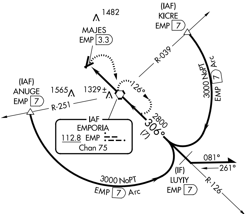
See that arc? It’s called a DME arc. Want to know why? Read on.
This is the VOR/DME-A approach to Emporia, Kansas. Depending on where you are when you join the approach, several different things can happen. If you’re approaching from the southeast, you’ll probably get cleared straight to LUYIY, and you can just fly the approach inbound. If you’re coming from the west side of the airport, you might get sent to the triangle labeled ANUGE (those triangles mark intersections, imaginary points in space that you use for navigation); from the northeast or east, you’d probably go to KICRE. In those latter two cases, you’d fly a constant-distance arc from the intersection to the final approach course. They’re called DME arcs because originally they required you to have a special navigation receiver known as distance measuring equipment. Now you can use GPS instead, unless you happen to have a DME receiver. To fly these approaches, you basically fly to the intersection, fly a distance, turn 10 degrees towards the center of the arc, and fly another distance. Think of it like making a circle out of straight lines. (There’s a decent explanatory video here if you’re interested in more detail).
Anyway, on to day 3’s work. Since we’d finished day 2 in the classroom, day 3’s morning was spent in the airplane. We took off from Manhattan and flew to Marysville (where we shot the GPS 16 approach) and then on to Plattsmouth, Nebraska: my first time to visit the Cornhusker State. I flew the GPS 34 approach, but not until Omaha Approach vectored me all over the place to accommodate some KC-135s working the traffic pattern at Offutt AFB. After landing, we borrowed a crew car and went to– no joke– Mom’s Cafe, where I had a chicken-fried steak about the size of my laptop screen. In fact, it was so big that I couldn’t eat the whole thing and declined the offered dessert.
After fueling the plane, it was off to Beatrice (pronounced “BEE-at-riss”), where I flew an approach– can’t for the life of me remember which one though; then we flew back to Manhattan, shot another GPS approach, and spent some time in the sim practicing ILS and VOR approaches into Topeka. Why Topeka? Tune in tomorrow to find out…


I am really enjoying this series of posts. Using the videos you linked to, I was able to follow along (quite clumsily) on my Flight Simulator X installation. Like being able to learn something new to use. I was even able to use the APR on the Bendix/King in the Mooney to get down in fog at KSLN using the video tutorial. Cool stuff!
Thanks, Marc. I still have several more posts to write but have been too busy to get to them. More on the way!