Tag Archives: IFR

Flying with Avidyne’s version 10.2 software

If you think updating the software on your phone is hard, try it with avionics.

Avidyne has been promising a new release of the software for their IFD line of WAAS GPS units for a while now. Originally announced on April Fool’s Day last year, version 10.2 packs a pretty impressive list of features, including synthetic vision, support for a bunch of new devices (including digital radar and FLIR cameras), display of more ADS-B weather and traffic data, and a new “IFD100” iPad app that essentially acts as a second screen for your IFD. They generously made the update available for free, but with a catch: it has to be installed by an avionics shop. The FAA lets aircraft owners make “minor repairs and alterations” (a phrase which has a very specific set of parameters around it), and avionics software updates aren’t considered “minor.” When they finally announced that 10.2 was available, the first order of business was to find a shop to install it. None of the local shops are Avidyne dealers, so we decided to head back to XP Services in Tullahoma. A quick phone call to schedule an appointment was all it took.

The flight to Tullahoma was pleasant, and the XP team had the upgrade done in about 2 hours– right about the amount of time Avidyne says it should take. The update procedure is very detailed and specific, with lots of dire warnings about what happens if you do it wrong, so I’m glad they didn’t. They also upgraded the software in our SkyTrax 100 ADS-B receiver, which will become important a little later in the story. I can’t say enough good things about XP’s staff: they did good work, quickly, at a fair price, and were very friendly. Be forewarned if you go there though: there are no vending machines nearby so bring your own snacks.

On the way home I got to start playing with the new features, but it wasn’t until last week’s Easter trip from Decatur to New Smyrna Beach that they really came into their own. Here’s a partial list of the new goodness in this release.

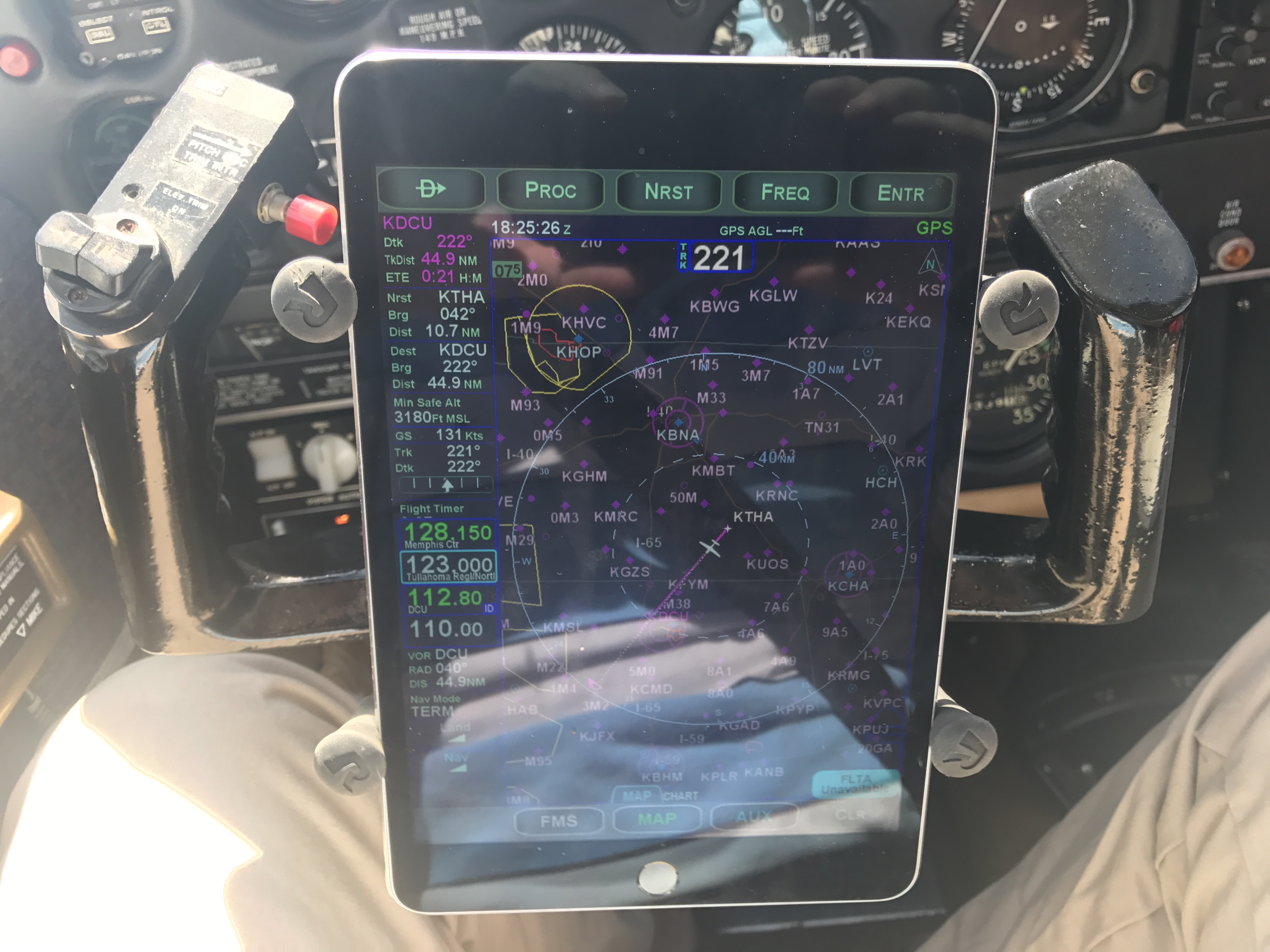
Let’s start with synthetic vision. The IFD540 doesn’t have a way to sense the attitude of the airplane, so its syn vis feature is limited to showing a “plane in trail” (Avidyne calls it exocentric) view of you, your route, and the surrounding terrain. In this case, I’ve programmed the ILS 18 Y approach into my home airport. You can see the magenta line indicating that I’m on the final approach segment. The white line-and-loop to the upper right is the missed approach procedure that I’d fly if I couldn’t land. There’s another airplane in the area, at 1900 feet and descending. The synthetic vision display makes very clear what the surrounding terrain and obstacles look like, and how my planned flight path would interact with them. This is not a huge deal in the flat riverine terrain near Decatur but in someplace like Montpelier, with more significant terrain, it could literally be a lifesaver.

heading for the approach

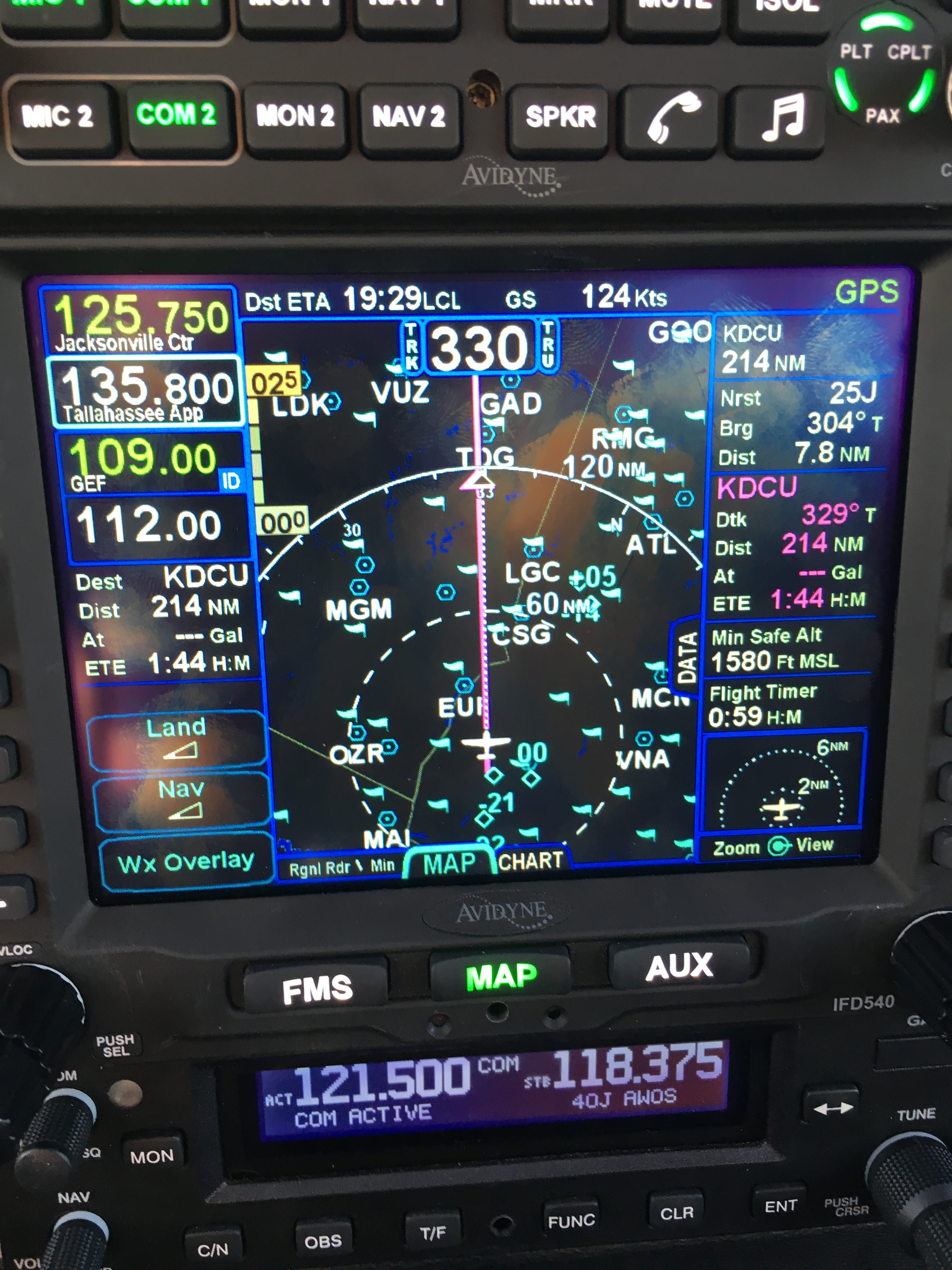
Another nifty new feature: temporary flight restrictions (like the one shown below, for firefighting in southern Georgia near Waycross) and winds aloft data (the little white flag-looking things in the second picture) can now be shown along with all the other flight data. You can see that we have about a 20kt headwind. It’s important to remember that, like all other ADS-B weather data, the wind data comes from the ground and may not reflect what’s truly happening in the air at that moment.

Don’t fly in TFRs unless you want to meet the FAA in person

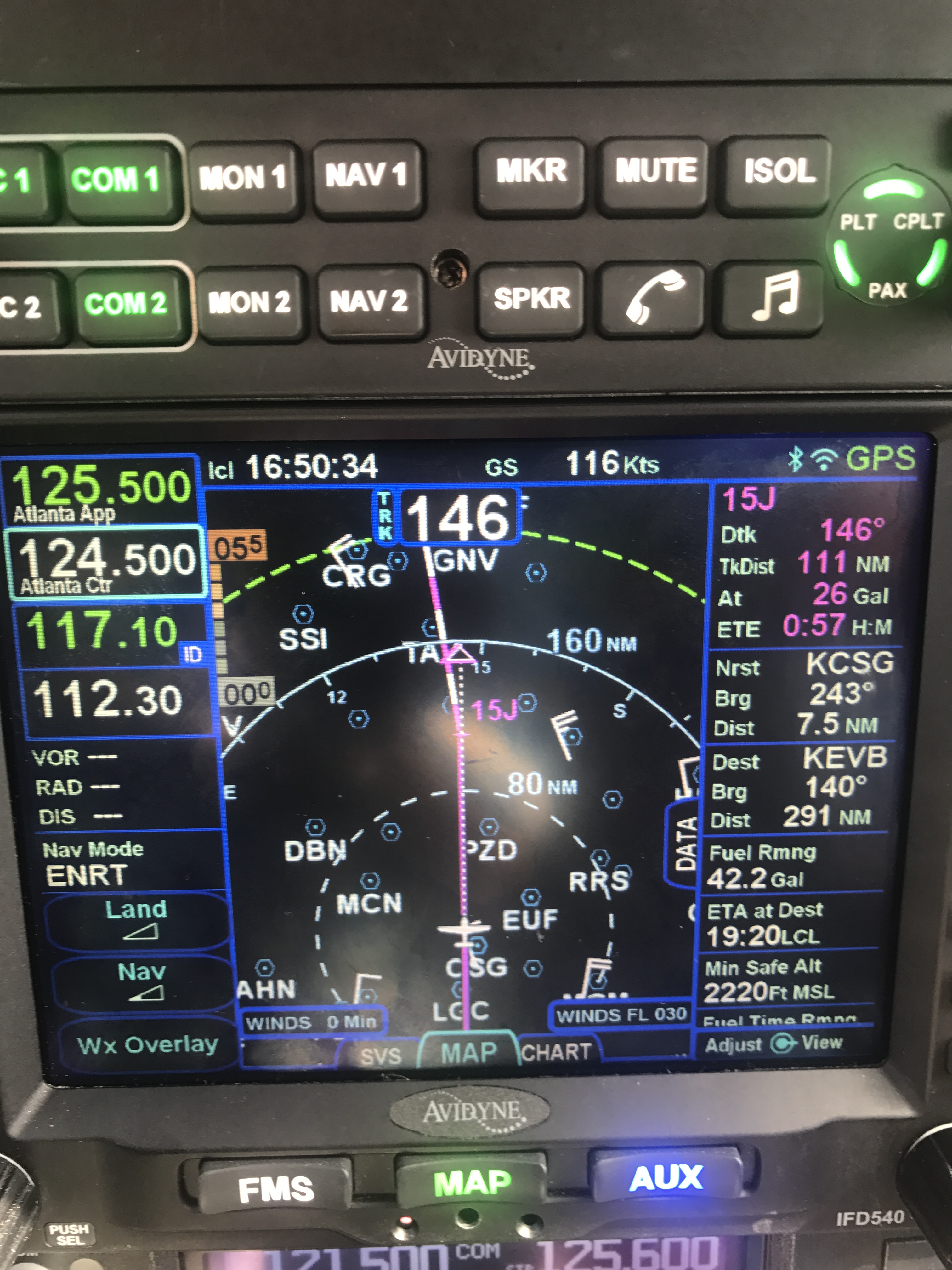
The direction of the wind barb shows which way it’s blowing; the number of little flags shows how strong it is

Traffic display is greatly improved in two ways. First, you can now see trend lines showing you where a traffic target is going (along with its N number, if it’s transmitting one). This is really helpful in crowded airspace, like the area around the Daytona Beach airport. You can see that both airplanes on the display are headed in the same direction as we are, one at roughly our same altitude and the other descending.

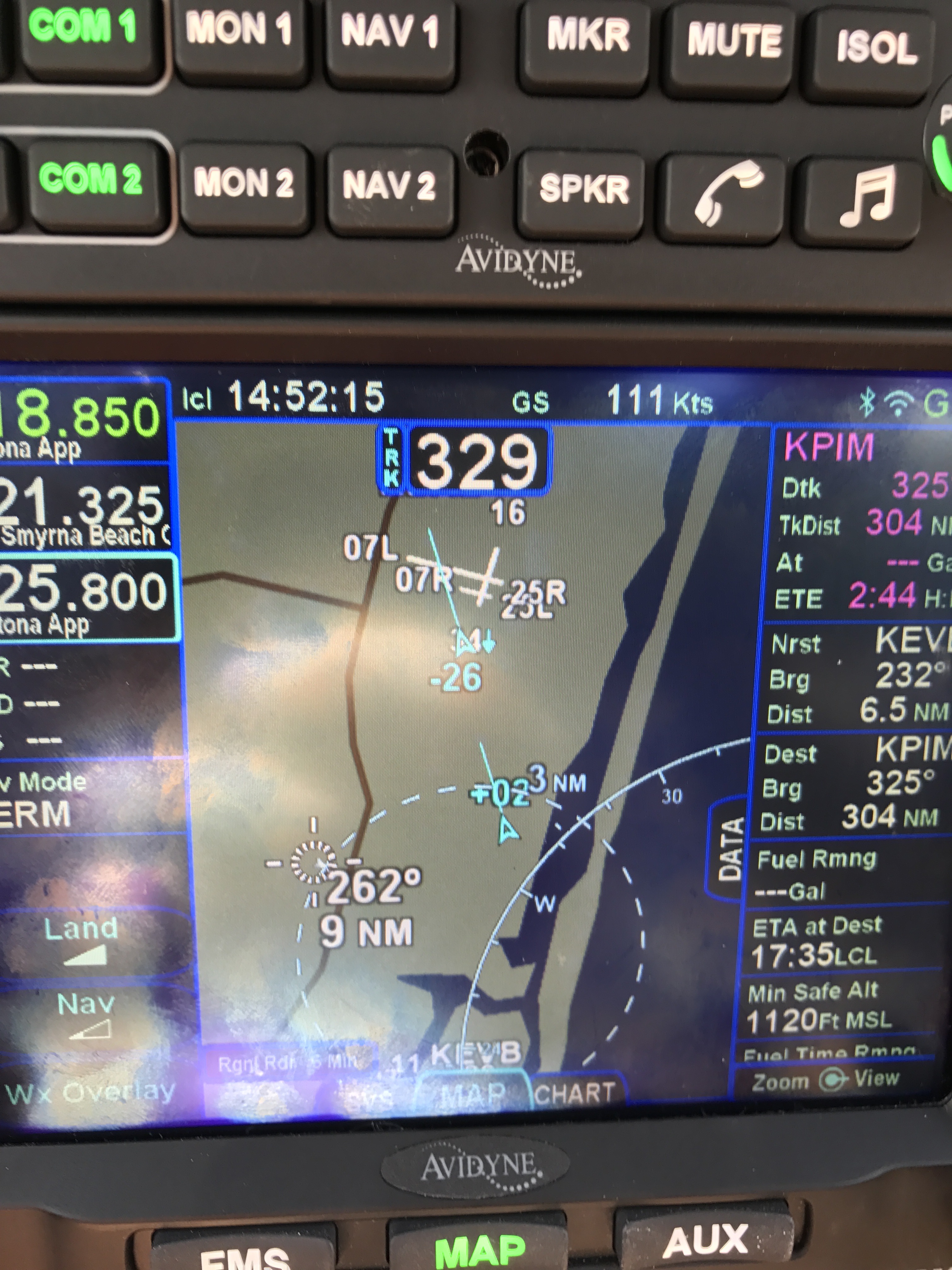
In 10.2, you can see where traffic targets are going

I also now get traffic alerts when there’s a potential conflict, i.e. someone else is flying towards me. An aural alert (“bong! TRAFFIC”) comes first, then the screen changes to show the conflicting traffic. This is an extremely valuable feature.

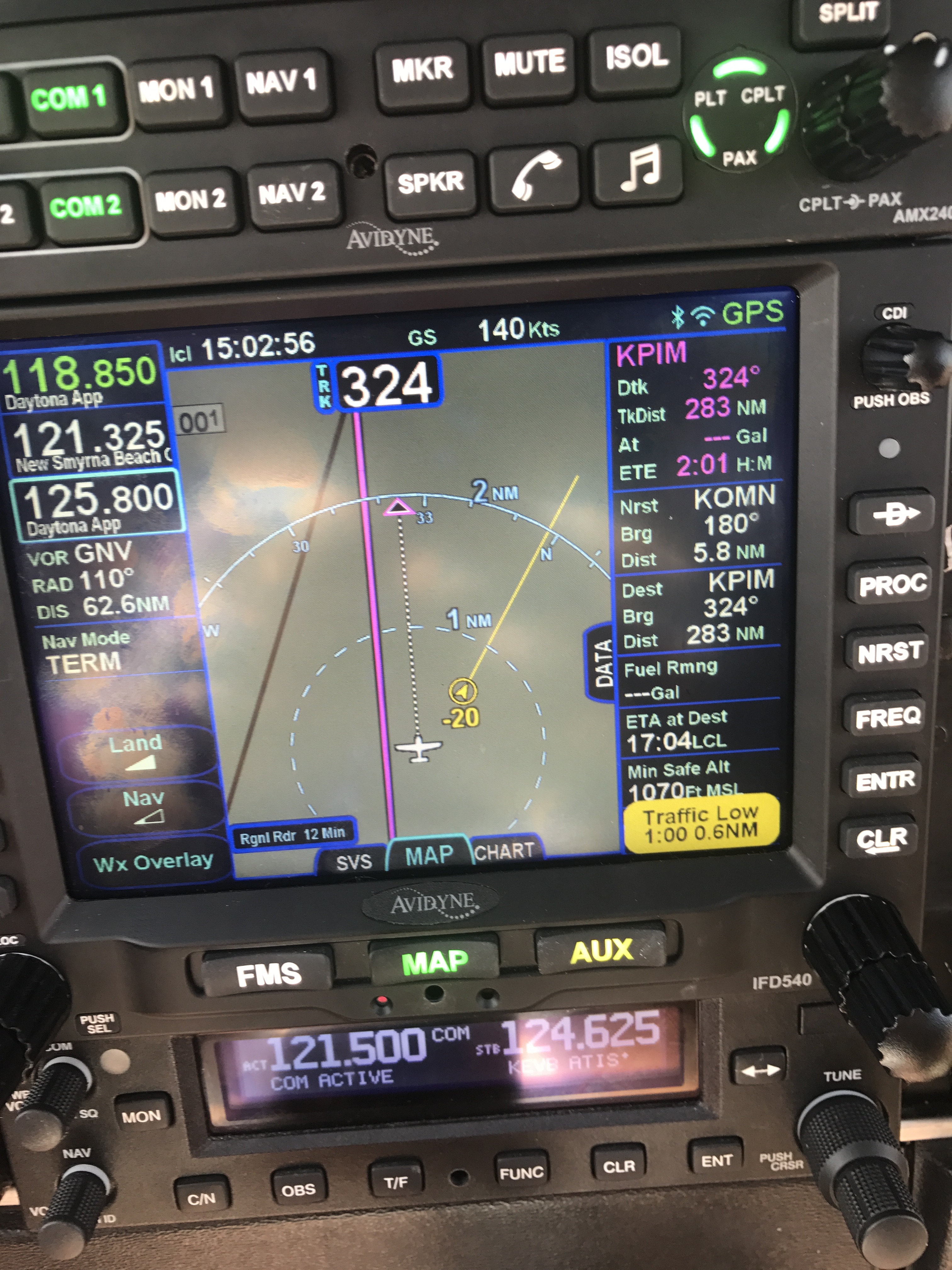
When you hear “TRAFFIC,” you’d better start looking around

The IFD100 app does what it promises: it lets you control the physical IFD, but it also lets you configure its display completely independently of the one on the panel. It does about 80% of what the “real” IFD hardware does. For example, you can load a flight plan into the iPad app while the panel is showing you the map/weather/traffic page, then push a button and activate that flight plan from the iPad. You can see and tune frequencies (but not activate them), zoom in and out on maps, and in general act like you have a second IFD540. It’s pretty neat, although there are some quirks to it that I’m still figuring out.

Not quite a replacement for Foreflight

The IFD100 app isn’t a replacement for FlyQ or Foreflight though; it doesn’t let you anything that the physical IFD can’t do, so no looking up fuel prices or FBO reviews, no satellite imagery display, and so on. ForeFlight has all sorts of useful planning features like terrain mapping, wind estimation, and flight plan filing that the IFD100 doesn’t, and won’t. I don’t think Avidyne intends the app to replace a true electronic flight bag (EFB) app, but rather to give you more options and flexibility with using the in-panel hardware.

I haven’t been able to test one of the signature features of 10.2 yet, though: its ability to do two-way sync over Wi-Fi between the panel device and a tablet. I can already stream a flight plan, and GPS position data, from the IFD to ForeFlight or FlyQ. 10.2 adds the ability for the IFD to send traffic, weather, and TFR data (which means I won’t need my Stratus receiver to see that stuff in ForeFlight), but also the ability to load a flight plan from the iPad to the panel. That means I can plan a complex route at my leisure in my armchair, file it, brief it, get my expected route, and push the route to the airplane when I get to the airport with a single button press. That’s going to be glorious when it finally arrives.

It speaks well of Avidyne that they made this major feature release available for free, and I’m excited to see how they continue to build on the wireless connectivity built into the IFD line.

4 Comments

Filed under aviation, General Stuff

First impressions: flying the Avidyne IFD540

cShort version: The transplant was a success and the patient made it home.

Now, the longer version.

I originally dropped the plane off on 31 December at Sarasota Avionics at Tampa Executive (KVDF). The plan was to have the plane ready by late January. That didn’t happen. When I went to pick the plane up on February 10th, it wasn’t ready as promised: the GPS steering steered the plane in the opposite direction as commanded, the interconnection between the new GPS and our engine monitor didn’t work, and the plane failed its initial FAA ADS-B Out automated compliance report (ACR) check. I was really unhappy, flew back to Huntsville, and started firing off emails to get the problem fixed. Long story short, Kirk Fryar, the co-owner of Sarasota, moved the plane to their Venice location, fixed everything that was wrong, tested the plane thoroughly, and had it ready for me on the 25th. (I note with some irritation that I still haven’t ever had an experience with any aircraft maintenance shop that resulted in the plane being ready when it was promised.)

I met Leonard, Sarasota’s check pilot and flight instructor, at KVDF and we flew the plane down to KVNC, stopping along the way to hand-fly the ILS 32 at KSRQ. It was a windy, bumpy day and ATC was vectoring me all over the place (including nearly to the Gulf ADIZ). I was a little rusty, and it showed. Another thing that showed: the localizer flag on the NAV1 CDI (we’ll call this squawk #1). This little flag is supposed to pop out to indicate that the associated signal is unreliable. It’s definitely not supposed to appear in a brand-new avionics installation, especially not when my secondary nav radio didn’t show the flag. We flew a missed approach and then took the RNAV 5 approach into KVNC. This time I let the autopilot and GPSS fly the approach, which it did flawlessly.

While I barricaded myself in their conference room to get some work done, Kirk investigated the cause of the localizer flag problem. It turned out to be simple, stupid, and Avidyne’s fault. There’s a known compatibility issue between early hardware revisions of the IFD540 and the King KI209A CDI we have. Sarasota sent our original unit back to Avidyne to have the hardware modification installed– we needed mod 14 but, for some unknown reason, we got a unit back that only had mod 11. This means that we have to take the plane back to the shop to swap in the new IFD540 unit when it arrives, which is a hassle… but more on that later.

After a thorough preflight, during which I confirmed that the fuel flow data presented to the IFD540 was intermittent (and that’s squawk #2, but not a huge deal since there’s a workaround: power-cycle both the CGR30P and the IFD540), I took off and picked up my clearance to Grady County. They gave me a route out over the water: direct TABIR, then direct 70J. I plugged it in, climbed out, and engaged GPSS. It flew smoothly to TABIR. There’s a lot going on in the picture below:

TABIR-with-traffic

  • The magenta line is where I’m going. Note that at the TABIR intersection, the onward path changes to a “candy cane” stripe to indicate the next planned leg. Other legs further on show up as white. This makes it easy to see what the box is planning on doing at all times.
  • The little blue diamonds are other airplanes, with their relative altitude shown and little up or down arrows indicating climbs or descents. The inner dashed ring has a 5nm radius, so I can clearly see where interesting targets are and what they’re doing.
  • The blue flags indicate VMC at those reporting points. this is a bit of a change from Foreflight, which uses little green dots for VMC METARs. However, the FAA specifies the exact symbology and colors that have to be used in certified devices so we’re stuck with those.
  • Just above the “FMS” button you can see a tiny label that says “Rgnl Rdr 9 Min”. That means I have relatively fresh radar data on screen; however, since the sky was completely cloudless when I took the picture, there’s nothing shown.
  • The radio at the bottom of the stack “knows” that 119.275 is the AWOS frequency for Venice. Why? The GNC255 has an onboard frequency database, and now that Sarasota connected it to a GPS position source, it can look up the frequency and aircraft position and use that combination to label who you’re talking to.

There was a stiff (25+kt) headwind and I was burning fuel faster than I liked, so I decided instead to stop at 40J. I landed, took on 62 gallons (meaning I had 20gals left, or a little over an hour’s flying time, in reserve) and set out for home. Along the way, I customized the datablock display– one of the big features of the IFD540 is that you can extensively customize what data is displayed and where it appears, then save that configuration in your own profile. That way Derek and I can each set up things the way we like, then load our own profiles on demand. Here’s what I came up with:

datablocks set up the way I like them

datablocks set up the way I like them

  • The left side top shows me the current communications and navigation frequencies I have tuned. Note that the unit automatically labels the frequency as soon as you tune it. (Not shown is the extremely useful FREQ button, which, when pushed, shows you a list of the frequencies you are most likely to need based on your location and phase of flight).
  • Below the frequency datablocks, I see my destination, distance, and estimated time enroute. I will see fuel remaining on arrival once the fuel flow issue is fixed.
  • The top line shows the current ETA to my destination, my groundspeed, and the current navigation mode. It says “GPS” in this picture, but it could also show other labels depending on whether I have an approach loaded, the type of approach, etc.
  • The right side shows, in order, the destination and distance (which I’ll probably remove), the bearing and distance to the nearest airport, and the track, distance, fuel remaining, and ETE for the next waypoint (that info is shown in magenta, indicating that it’s tied to the current waypoint). Because I am going direct to my destination, this magenta block is the same as the destination data on the left. (You can also see the minimum safe altitude and flight timer, right over the traffic display thumbnail).

On the way home, I decided to do a couple of turns in the hold at the ATHEN intersection. This is normally part of the RNAV 36 approach to Decatur; I didn’t want to fly the whole procedure, but I wanted to see how the IFD540 handled a hold at an arbitrary waypoint. Turns out it’s just about as simple as you can imagine: you pick the waypoint (any one will do: airport, intersection, VOR, whatever), tell the box you want to fly a hold, and then watch it do its stuff. When you want to exit the hold, you sequence the next waypoint as direct and the magic happens. Thanks to GPSS, the plane happily flew the entire hold on its own, including compensating for the winds.

One more squawk: the IFD540 and the other devices are super-bright in their default night modes. I think the dimmer settings are wrong, because the panel light rheostat that controls all the other lighting (including the CGR30p) did nothing to change the brightness of the IFD540, so I had to manually adjust it. All of these squawks will be addressed when we take the plane back to Sarasota’s shop, this time the one in Tullahoma, just a short flight from here. It shouldn’t take more than 15 minutes or so to swap out the IFD540; fixing the other issues might take a bit longer.

First impressions of using the IFD540 for a cross-country IFR flight:

  • I am very impressed with the display brightness and clarity and the overall build quality of the switches and knobs on all of the hardware.  Being able to switch between items using the left/right rocker switches (labeled “FMS”, “MAP’, and “AUX”) is easy and intuitive. Touch response is fast, and multitouch for panning and zooming worked flawlessly.
  • The UI is responsive and the graphics are clear and readable. The screen seems huge compared to my old KLN94.
  • By default, the combination of land and navigation data presented on the map is cluttered, but it’s easy to declutter.
  • Avidyne brags about their “hybrid touch” interface, in which nearly every action can either be performed directly on the touch screen or by using the knobs and buttons. That  flexibility works very well and was most welcome during my bumpy flight home– aiming precisely at a touchscreen in moderate turbulence can be a challenge.
  • Once you get used to the notion that there are sliding tabs (like the “DATA” tab visible next to the “minimum safe altitude” field in the picture above), it becomes very easy to flip between sets of data, such as the flight plan view when in FMS mode.
  • The location awareness features of the IFD540 are a real time saver. The FREQ button knows what frequencies to present based on where you are, the unit can automatically tune (and ID) the next VOR in your flight path, and so on.
  • Speaking of FMS: flight plan entry, approach management, and so on use a metaphor that’s close to, but still different from, the King/Garmin-style interface that most pilots are used to. It’s like the difference between Brazilian Portuguese and Portuguese Portuguese: lots of common vocabulay and idiom, but some very important differences. I’ll have more to say about that once I have more time flying with it and learning the FMS way of doing things. (It’s interesting that Bendix King, whose KSN770 competes with the IFD540, has the same issue in that the KSN77o steals a lot of FMS-style behavior from BK’s jet FMS family.)
  • The top-of-descent (TOD) marker is a really nifty feature; it tells you where to start your descent in order to hit an altitude constraint on the flight path. The audio cue, along with the audio cue for 500′ AGL, are very valuable prompts. I’d love to see Avidyne add an audio prompt indicating when you reached the missed approach point (MAP) for approaches that define them.
  • I think, but have not confirmed, that the IFD540 should be able to drive the STEC PSS so that the autopilot  can follow an LPV-generated glideslope. It will take a little knobology for me to figure out how to set this up, though.
  • There are many things I learned to coax the KLN94 into doing that I don’t yet know how to do on the IFD540, so this learning process will take a little while. On the other hand, there are many, many things that the IFD540 can do that the KLN94 and Garmin GNS-x30 series can’t.

What about the rest of the stack? Well, the transponder just works… not much to say there. It transmits ADS-B Out like it’s supposed to, so I’m delighted. The AMX240 audio panel is a huge improvement in audio quality and functionality over the old KMA20 we had before. I’ll have more to say about those gadgets, and the GDC-31 roll steering converter, in the future. Overall, I’m delighted with the new stack and can’t wait to fly it a bunch more!

Leave a comment

Filed under aviation

Flying Friday: a sample of instrument flight

Bonus! Two Flying Friday posts in one day (here’s the other one.)

There’s a difference between flying under instrument flight rules (IFR) and flying in instrument meteorological conditions (IMC).

When you fly IFR, that means you’re flying on an instrument flight plan, along a defined route, in communication with and under positive control of ground-based air traffic control.

When you fly in IMC, that means you are flying “primarily by reference to instruments,” as the FAA puts it. That basically means that you can’t see a discernible horizon. You can fly IFR in good weather or bad. If you’re flying in IMC, you must do so under IFR. If you’re flying in visual meteorological conditions (VMC, what normal people call “good weather”), you can fly under visual or instrument flight rules.

Actually, I should clarify just a bit– VMC isn’t necessarily good, it’s just that IMC is defined as “weather worse than the standard VMC minimum visibility and/or ceiling.”

This whole post is basically just an excuse to post a short video showing one example of flight in IMC. I took it while en route from Decatur to Tampa Executive; on that 3h40min flight I was in the clouds for just under an hour.

You can’t see a visible horizon, although the sun was semi-visible through the clouds. (If you take a look at the iPad screen, you’ll see why it was so cloudy.)  Surprisingly, on a sunny day, the inside of the cloud can be very bright with diffuse light, leading to the somewhat odd behavior of wearing sunglasses while flying inside a cloud that blocks the sun from the ground.


Leave a comment

Filed under aviation, General Stuff

GATTS days 8 & 9: judgment day(s)

The title of this post gives it away: I didn’t pass my check ride on the first try. Read on to find out why…

On day 8, I woke up early, loaded the car, and drove to the airport to meet Peter. We’d arranged with Ken to meet early because the weather from Manhattan to Topeka (and the surrounding area) was poor: 1200’ or less ceilings, with lots of wind and a good bit of rain. Peter and I agreed to head east and see what the weather looked like when we got there. Short answer: it was terrible. The entire flight was in clouds, with plenty of bumps, then on arrival, ATC gave us about 20 minutes of holding on the localizer, which was, um, invigorating, not to mention bouncy. We finally landed and this is what we saw:

Paul robichaux net 20140903 001

Ken was there waiting for us, so we went inside and went through the standard check ride prep; he and I both signed into IACRA to complete my check ride paperwork, he briefed me on the Pilot’s Bill of Rights, and so on. Then we spent about an hour on the oral exam, which was perfectly straightforward. I wasn’t surprised by any of his questions, largely thanks to the combination of Peter’s coaching and my own study. The weather wasn’t good enough for us to conduct the practice approaches on the check ride under VFR conditions, so we adjourned to the airport restaurant for a snack (which was interrupted by a business phone call for me, alas). After about an hour and a half, the weather had lifted enough for us to fly. We took off, and Ken had me intercept V4 to give us some distance from the airport. We flew west a bit, then he had me recover from unusual attitudes, which went well… except.

See, I was having a hell of a time keeping to my assigned altitude. I’d like to blame it on the wind, but it wasn’t just that; my scan was deteriorating faster than ever before. I’m still not sure if I was nervous, rattled from the weather, or what, but after a few gentle reminders from Ken (example: “Do you know what the PTS requirements for holding altitude are?”, just in case my poor performance was due to ignorance vice lack of skill), he had me head in to the ILS for runway 13. I flew fairly well despite the wind gusts, intercepting and tracking the localizer without a problem.. but, again, my altitude control was poor, and I let the glideslope needle hit full deflection down. I was too high, and that was that: he had me land, gave me the dreaded letter of discontinuance, and held a short debrief with Peter and me. Then I flew us home, in a funk the whole way; we did some remedial training en route, which I obviously needed but didn’t want. After landing I went back to the apartment, sulked for a while, worked a bit, and then mentally steeled myself to repeat the process the next day… and that’s exactly what happened. The next morning, we went back to the airport, flew to Topeka, met Ken, did the same IACRA stuff, and went out to the airplane.

When you retake a failed (or interrupted) checkride, the examiner doesn’t have to retest you on the portions you passed, although she can. In my case, Ken just wanted me to fly the approaches and holds, which I did, starting with the ILS for 13. It was still breezy, but nowhere near as windy as the preceding day, and/or maybe I was less nervous. In any event, I flew a textbook ILS approach, did a decent job on the hold (despite a stiff and inconvenient crosswind), and followed with the VOR and localizer back course approaches. I landed, taxied in, and Ken shook my hand to congratulate me. Here’s what the airport looked like when we taxied up:

Paul robichaux net 20140901 003After another debrief, in which the often-heard and completely true phrase “license to learn” was tossed around several times, we bade Ken goodbye and headed back to the ramp. After a short and uneventful flight back to Manhattan, I shook hands with Peter for the last time, got a fresh diet Coke, and headed home. The flight home was smooth and clear, so I didn’t actually get to perform any approaches, more’s the pity. After such a long time away, I was delighted to get home, sleep in my own bed, play with the cat, and generally settle in a bit.

Once a little more time has passed, I’ll write up my overall impressions of GATTS. It is safe to say that I’m pleased with what I learned and their teaching methods, but I feel like I need a bit more experience before I form a complete opinion. Meanwhile, I’ll be flying!

8 Comments

Filed under aviation

GATTS day 7: checkride prep, plus a race

Day 7 of my GATTS experience happened to be Labor Day. That didn’t really make any difference to the flight schedule, but I did talk Peer into a later start time so that I’d have time to go run the Summer Send-Off 5K race in nearby Chapman, Kansas. The race was a lot of fun; I ran well despite getting lost on the way there and arriving literally 30 seconds before the starting gun. (Irony of the day: just as I was passing the high school demolished by a 2008 tornado, my iPod served up Flux Pavilion’s “Blow the Roof”).

Race in Kansas? Sure, why not? One more state on my list that I can cross off.

Race in Kansas? Sure, why not? One more state on my list that I can cross off.

After the race and a quick shower, I met Peter at the airport for a mock checkride. Checkrides are normally administered by people who hold the role of DPE, or designated pilot examiner. They’re not FAA employees; many of them are very high-time instructors, often retired. Every instructor knows, or should, the local DPEs: what they think is important, what they emphasize in the oral and practical exams, what their habits and idiosyncracies are. Although Peter didn’t attempt to imitate the DPE’s mannerisms or anything, he did tell me that I should expect to take off, intercept the V4 airway westbound, return to do the ILS 31 approach at Topeka, execute the published missed approach, transition to the VOR 22 approach, and then come back to do the localizer backcourse for 13. This last was necessary because of FedEx’s failure to deliver my updated GPS card on time, the dirty rats– I couldn’t legally fly a GPS approach without the updated data card, so I was stuck with the backcourse.

The first part of any FAA checkride, of course, is the oral exam, so Peter quizzed me for an hour or so on weather, procedures, approaches, lost communications procedures, and pretty much everything else we had discussed at any time during the preceding week. That went well, I thought; I felt well prepared by the combination of my study and his teaching. Then we went out to the ramp, fired up the airplane, and flew to Topeka to simulate the flight check portion. The flight went very well, although it was windy and bumpy, so I had trouble maintaining the nice oval shape we all associate with a well-flown holding pattern. Part of the goal of the simulated checkride is to put the applicant at ease with the flow of the ride, and it definitely helped; despite the blustery winds, I flew within the PTS and felt good once we got back on the ground and put the plane away. I had an easy night, packing and making one last visit to Hibachi Hut for bread pudding and a sandwich, then went to bed, eager to face the DPE on the morrow…

Leave a comment

Filed under aviation

GATTS day 6: building comfort

[ sorry about the gap in posting the rest of my GATTS writeup; I’ve been kinda busy. ]

Day 5 of my GATTS experience was all about refinement. We started in the classroom, where we covered the rules for filing alternate airports and spent a good bit of time on decoding IFR charts (which, luckily, was one of the areas where I worked extra hard when studying for my written). Then we got in the airplane and flew to Topeka to shoot the ILS runway 32 approach, something that Peter told me would almost certainly be featured in my checkride. The GPS in 706 is not equipped with a WAAS-capable GPS, which means that I can’t fly precision GPS approaches. That means that, if I want a precision approach (and who wouldn’t?), it’s the ILS for me, at least until we can upgrade to a newer GP

Of course, one of the most important parts of flying an approach is the missed approach procedure– the sequence of steps you take when, after flying the approach, you’re unable to land because of poor visibility, runway misalignment, and so on. When you’re practicing an approach, it’s common to tell ATC what you’re going to do after the approach– land, execute the published missed approach procedure, or do something else. In our case, we flew the published miss for the ILS 32 approach, which involves flying to the Topeka VOR and then flying a racetrack holding pattern. For a real missed approach, ATC might send you to the normal missed approach holding point, or they might vector you around for another try, depending on the reasons why you went missed.

After the missed, we flew on to Miami County. No, I’d never heard of it either. It turns out that there is a superb BBQ restaurant at the airport, We B Smokin, so after shooting a good GPS approach, we had lunch. I accidentally ordered enough food to feed two normal humans, so by the time we were done eating I was a slow-moving hazard to navigation. We fueled up and departed for Forbes, flew the VOR/DME, and then went back to Manhattan. This was fortuitous timing, because there was a line of thunderstorms poised to attack from the west, so we called it a day and I went to Manhattan’s only movie theater for November Man (pretty decent; worth the $6) and a large bucket of popcorn, followed by watching the storms roll in from the safety of my balcony.

By this point in the training, I was feeling very comfortable operating “in the system”: my radio calls were concise, I was getting better at visualizing what the approach I’d selected would require me to do, and I was much more comfortable with the workload required to brief and set up the approach, then fly it to either a landing or a missed approach. The steady diet of daily flying, in whatever weather we happened to have, was a key part in building my comfort level. Although the flying weather to this point had been pretty good, the stiff, variable winds we had all week were more than enough to challenge me– just what I was looking for.

2 Comments

Filed under aviation

The instrument written exam

As described in FAR 61.65, the FAA requires three categories of things to earn an instrument rating: you have to meet the experience requirements (which includes things like being proficient in English and convincing your instructor to sign you off), you have to pass the practical test, and you have to pass the written exam. I haven’t had much opportunity to fly with my instructor lately, so I’ve been focusing on studying for the written exam, which covers weather, IFR procedures, regulations, how to read IFR charts, and all sorts of other goodies.

NewImage

The picture above shows a portion of the IFR low chart surrounding David Wayne Hooks Airport in Houston. Yes, the FAA really expects you to know what all that stuff means! Every little symbol and text block has its own particular meaning: minimum en-route altitudes, crossing restrictions, distances, and lots of other things are all encoded into the symbology, and there is a completely different visual language used for diagramming instrument approaches. That’s a shorthand way of saying that there’s a lot of bookwork required to be ready for the test. I’ve been using the Sporty’s IFR course, which is pretty good, along with their test-prep app. I’m re-reading Taylor’s Instrument Flying and working my way through a couple of other books I have. Finally, I am considering taking one of the weekend accelerated ground schools offered by companies such as Aviation Seminars and Rick Yandle, but that requires at least one full weekend of time, plus several hundred dollars— money and time I could be using to fly instead.

Now, time to hit the books again…

Leave a comment

Filed under aviation