True fact that sometimes shocks people when I share it: a pilot certificate never expires.
Sure, it can be revoked by the FAA if you do something stupid. I suppose you could ask the FAA to cancel it for you, sort of like resigning from a church. But once you obtain the certificate, it’s yours forever, even if you stop using it.
However, in order to legally exercise the privileges granted by that certificate, you need (at least) two things. First, you need a valid medical exam (a worthy topic for a future post). The type of exam you need varies according to the certificate, and the frequency at which you must have it varies both by the type of exam and your age.
Second, you need to be current. This is an interesting word. The FAA doesn’t say you have to be “proficient,” just “current.” What does that even mean? Glad you asked. To be legally current as a private pilot, you must have completed a biennial flight review within the preceding 24 months. That’s it. There’s no set structure for the BFR, other than that it must consist of one hour of ground training and an hour of flight. There’s no set syllabus or standard, as there is with almost every other type of flight training activity. The FAA’s guide to conducting BFRs likens the BFR to a checkup, where each individual doctor is supposed to tailor the specifics of the checkup to a specific patient. Many organizations, such as the Redstone flying activity, specify what they consider the minimum coverage for the BFR to be in order to use their airplanes, but that’s not mandatory.
The currency structure changes a bit if you want to fly under specified circumstances. To carry passengers, you also need 3 landings within the previous 90 days– so you can’t just get a BFR after being inactive, then load up your plane with your friends and head out. To fly with passengers at night, you need 3 landings to a full stop, at night, within the previous 90 days. To fly in instrument conditions, you need 6 instrument approaches (including course tracking and holds) within the preceding six months.
The purpose of these currency requirements is to force recency and proficiency. The idea is that if you fly regularly, you will stay proficient. If you don’t fly regularly, you need to regain currency before you can fly with passengers, thus forcing you to regain proficiency. However, the way the regs are written, you can not fly for 20 years, jump in an airplane and have a de minimus BFR, then do 3 laps around the traffic pattern to get your landings in and then immediately start flying with passengers. That might be legal, but it wouldn’t be either smart or safe.
One approach to keep proficiency is just to fly enough to stay current. If you never let your currency elapse, the theory goes, then you’ll be getting enough air time to stay proficient. This isn’t true for everyone; I know that after I’ve been away from the plane for longer than a few weeks, some skills need sharpening on my next flights. This is especially true for instrument flying, and even more so when you have an unfamiliar airplane, new avionics, and the like.
Last night, I went on a currency flight. I had lost my night currency and needed a couple of instrument approaches to keep my instrument currency. In order to log an instrument approach, you either need to fly in IMC or with view limiting devices, which means you need a safety pilot. Since I am super safety minded, I brought two (hi, Alex! hi, Greg!) Interestingly, when you are not current, you can’t take passengers with you, but you can take safety pilots and/or instructors. Anyway…
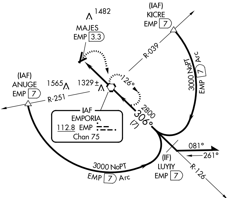
After a perfectly normal preflight, runup, and takeoff, we were in the air about 810pm, just over an hour after sunset. According to the FAA, that’s when night starts. The plan was to do an LPV approach at Huntsville Executive, an ILS at Huntsville International, and then another LPV at Decatur, landing at each. That would give me 3 night takeoffs and landings, plus three instrument approaches and a procedure turn (which counts as a hold for purposes of maintaining IFR currency).
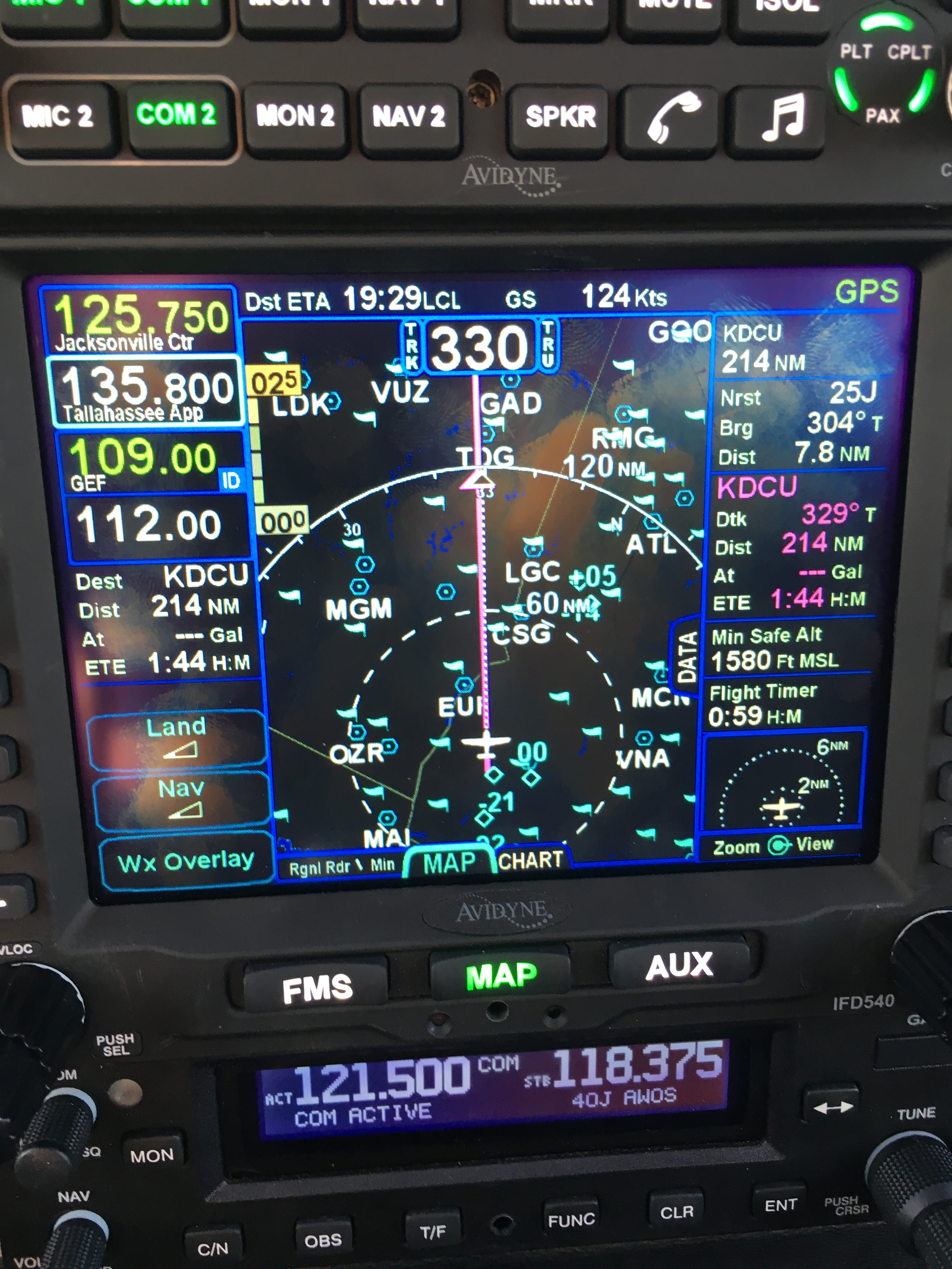
Before takeoff, I programmed the IFD540 with the airports, but didn’t load the approaches. Once airborne and talking to Huntsville departure, I asked for the RNAV 36 at MDQ, got the clearance, and programmed the box, then engaged the AP. It flew us to the procedure turn, through the turn, and on course flawlessly. I had the AP in HDG mode, the GPSS in GPS mode, and all was fine. Inbound to the FAF, I armed the GS mode on the PSS, and shortly thereafter found that the AP had turned me about 30° to the right of course. I don’t know if it was the GPS or the AP, but I disconnected the AP and manually flew the missed procedure. This was a great illustration of why currency matters– with new avionics, I’m still learning how to set up and program approaches, and it’s a hell of a lot smarter to get that practice with two other pilots on board, in good weather, than to try to figure it out in the midst of an actual IMC approach.
For the second approach, I got vectors towards HSV for the ILS to runway 36R; the controller put me between the ENIKY and UJOTY intersections, so all I had to do was turn inbound and intercept the localizer. I manually tuned the localizer frequency on NAV2, used the FREQ button to tune it for NAV1, and verified that I saw “GPS->VLOC” on the display– that’s the signal that the GPS is aware that I want to transition from GPS-derived guidance to guidance signals from the ground-based localizer and glideslope. I armed GS mode on the PSS just after the final approach fix (FAF); the localizer and GS both came in normally and the AP flew a flawlessly coupled approach down to about 1000’, when I disconnected and hand flew the rest. That was full-stop night landing #1. Because Huntsville has such long runways, I was able to land, stop, and take off again on the same runway, which is always nice.
On takeoff, I asked for vectors to the RNAV 36 at DCU and got them. This time, I wanted to check my proficiency at hand-flying the approach. I hand flew the climb, cruise, and approach, using the GPS only for reference, down to about 1300’ AGL and then landed (night landing #2) and a back-taxi, followed by 1 lap of the pattern and a visual landing for #3. Having the advisory glideslope on the approach was nice since DCU doesn’t have VASI or PAPI lights to indicate whether you’re on the right glidepath.
All in all, a good night; I am once again legally night current and have extended my instrument currency. I still want to fly some fully coupled LPV approaches to make sure I understand the buttonology but my knowledge of the IFD540 is definitely coming along. Thanks to the latest Foreflight app update, Greg, Alex, and I were all getting GPS position and flight plan data from the IFD540 streamed to our iPads, which was cool. We also saw active weather and traffic on the IFD, which I loooooove. Avidyne announced last night that they’re about to start streaming traffic data to Foreflight as well, which will be really nice. Now to get ready to fly to KNEW in two weeks for my race!


 After another debrief, in which the often-heard and completely true phrase “license to learn” was tossed around several times, we bade Ken goodbye and headed back to the ramp. After a short and uneventful flight back to Manhattan, I shook hands with Peter for the last time, got a fresh diet Coke, and headed home. The flight home was smooth and clear, so I didn’t actually get to perform any approaches, more’s the pity. After such a long time away, I was delighted to get home, sleep in my own bed, play with the cat, and generally settle in a bit.