Tag Archives: avidyne

Flying Friday: Avidyne IFD540 10.2.3.1 upgrade notes

For a while now, I’ve been waiting for a new update to the GPS software in my airplane. The last major update was about two years ago, so it was about that time. Avidyne had originally planned to release this set of features as version 10.3, but it turns out that, for some mysterious reason, the FAA update process for a “major” update applies to a version update. So releasing the software as 10.3 would have required a longer certification cycle than releasing the same thing as 10.2.3.1, which makes very little sense to me given that this update touched literally every part of the IFD’s firmware and software.

After the software was finally done, Avidyne had just submitted the software for certification and… government shutdown.

Then they decided to do a separate release just for the GPS week-number rollover bug. That update could be released nearly immediately, but it didn’t include any new features. However, like all software updates for avionics in certificated airplanes, you can’t just plug in a USB stick and go; updating the software is considered to be an alteration and so requires a logbook entry signed by a certificated airframe & powerplant (A&P) mechanic. Rather than make a separate trip just for the GPS fix, I elected to wait until the full release was ready, and so when it dropped last week I immediately emailed the shop to make an appointment.

As with every other software product, this update was a combination of bug fixes and some new features. The new features that I was most interested in were the ability to stream ADS-B data from the IFD to Foreflight and the ability to load instrument arrival and departure procedures without a transition. Here’s how my first flight with it went.

First, I preflighted and flew the short hop from Decatur to Tullahoma, Tennessee, where XP Services is located. XP is a great shop: they are quick, efficient, and they do good work. When I pulled up to the hangar, the tech already had the installation instructions printed and a GPU cart waiting, which is mighty fine service for a Friday afternoon before a 3-day weekend. I went into their conference room to work while the mechanics worked through the long install procedure. It requires continuous power to the GPS, along with a bunch of separate reboots and firmware updates. The instructions have a lot of dire warnings in bold red type. I’d certainly have been capable of doing the update myself but I liked the security of having the shop do it so that I wouldn’t make a stupid mistake that bricked the unit.

The update went fine; they billed me for 1.61 hours (oddly specific, but OK, whatever) All of my settings were properly preserved, and immediately after the update I was able to load the 23 May navdata cycle without incident. I happily flew home $156 poorer but eager to see what the update brought.

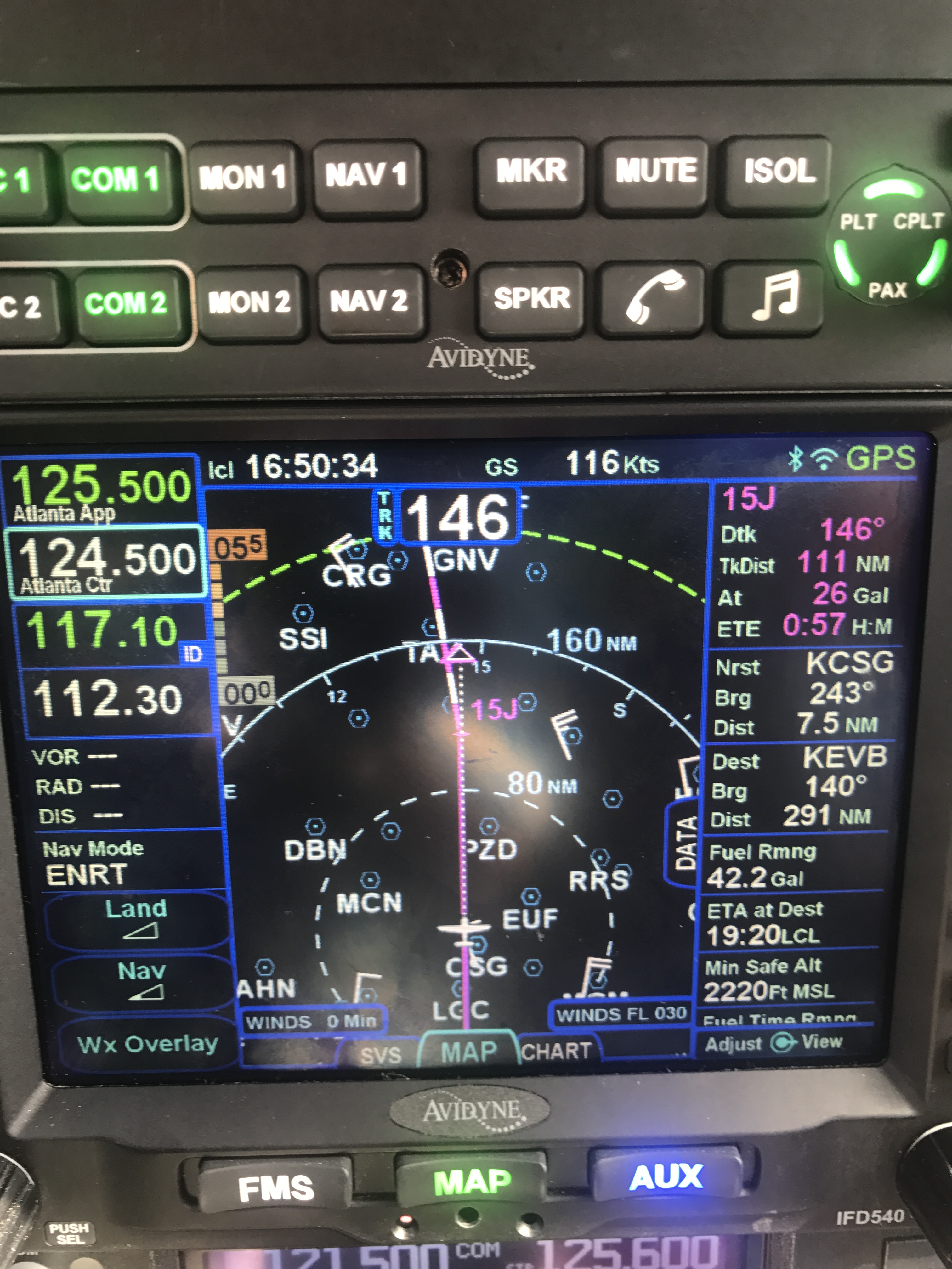
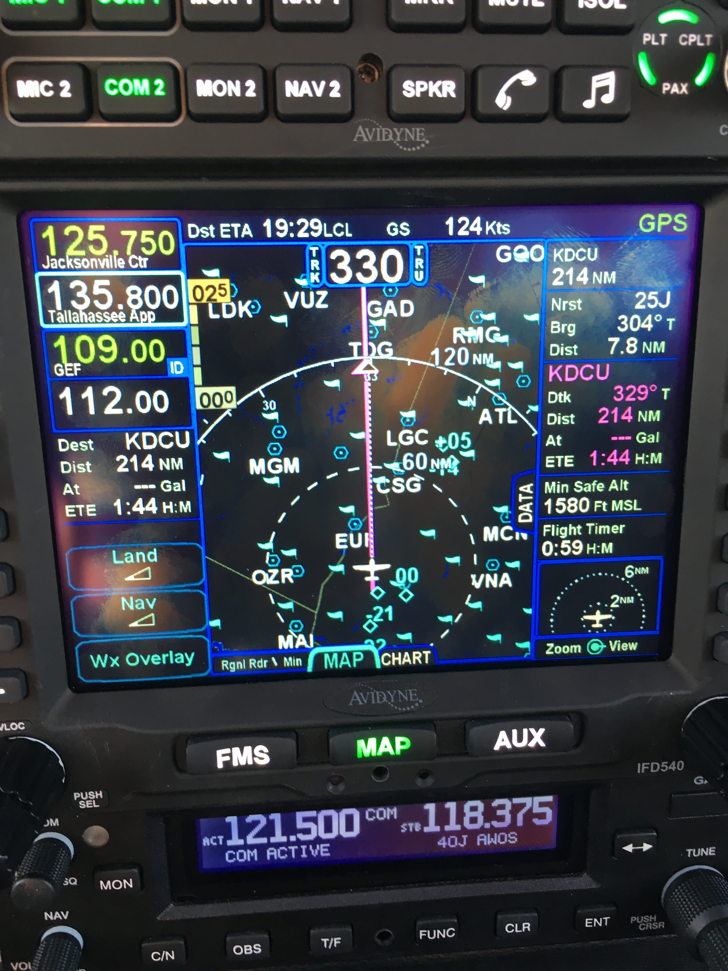
Last year, the FAA announced that they would start sending additional weather data over the FIS-B data link protocol. I have a box (the SkyTrax 100) that is essentially a modem; it receives ADS-B data (which includes FIS-B weather), demodulates it, and passes it as a stream to the IFD. That box didn’t require any updates to display the new weather data (which includes lightning strike, icing, and cloud-height data) but the IFD couldn’t interpret it until this update. I really wanted the lightning data for the summer and the icing data for the winter— both of these are important cross-checks that help clarify what’s really happening inside the clouds. Once I was airborne and established, I was able to see lightning data in some storm cells off to my west, so that part of the update clearly works. The weather was sunny and clear for probably 200nm around me, so there wasn’t much else to see.

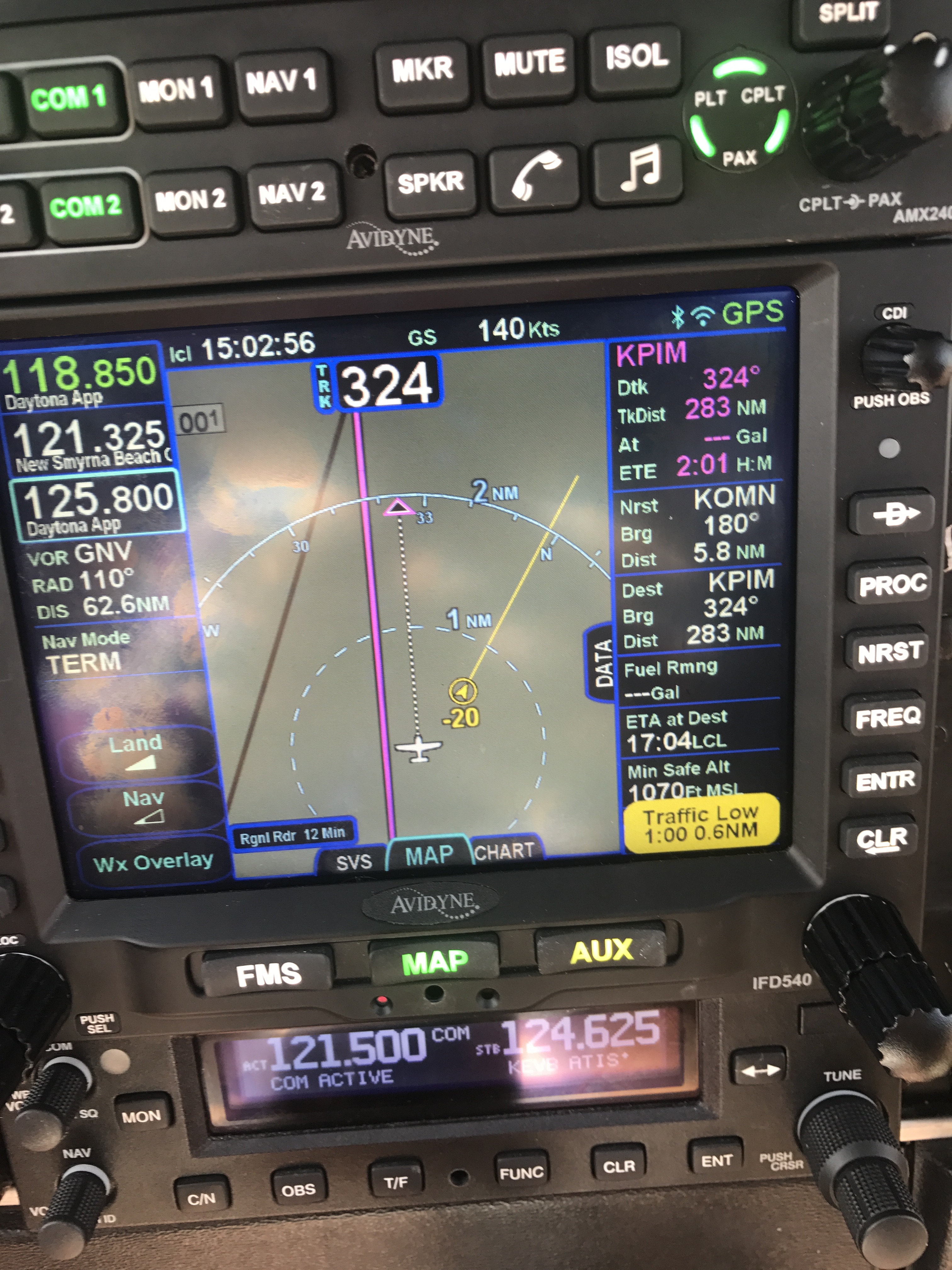
The other major feature I wanted was integration with Foreflight. Since early in its life, the IFD series has been able to wirelessly connect to external devices to upload and download flight plans, send GPS position data, and send ADS-B streams. The idea is that if you’re using a tablet app like Foreflight or FlyQ, you can use your panel-mounted GPS and ADS-B receiver to feed position, weather, and traffic data to the tablet app. For a variety of boring technical reasons that I won’t go into here, ADS-B streaming hasn’t worked properly with Foreflight until this release (although GPS position streaming and flight plan up/download did work). Now it does— those little blue arrows are other aircraft, and the radar display is live FIS-B data (including lightning data). I was also able to look at the icing level forecast, which is going to be invaluable in the wintertime for tactical weather avoidance.

IMG 0011

There’s one thing that Avidyne took away in this update, though. They previously had an aural “traffic!” announcement that was triggered when the IFD detected traffic within a certain radius. The unit still gives you a visual indication, but no more audio prompt— having it violated some FAA standard or other. However, I was happy to see that Foreflight provides audible traffic callouts based on data from the IFD– so now I probably need to decide whether it’s more valuable to have my phone or iPad connected to the AMX240 during flight.

The second thing I wanted was the ability to load arrival or departure procedures that don’t have a transition. This requires a bit of explanation. These procedures (SIDs for departures and STARs for arrival) specify a route for how you arrive at or depart from the airspace near an airport— they provide a way to transition between the terminal environment and the en route environment. For example, see this plate for the SWTEE.1 arrival procedure, which is used in Atlanta airspace to handle aircraft arriving from the west and slotting them into the correct flow for whatever airport they’re going to. ATC will usually assign the arrival while you’re still en route, and they may or may not assign a transition. For example, they could give me BIZKT.SWTEE1 (pronounced “biscuit transition for the sweet tea 1 arrival”) or LPTON.SWTEE1. So the IFD expects you to specify a transition point when you load a SID or STAR. The problem is, sometimes you don’t get one assigned from ATC (and you can’t just make up your own). When I fly in from north Alabama, my direct route will normally take me north of those routes, so typically when I’m somewhere just northwest of RMG, ATC will call me and amend my route to give me something like “direct OKRAA, thence the SWTEE1 arrival”. It’s simple enough to load the STAR and then sequence the leg I want, but keep in mind that the flight management system (FMS) in the IFD is always expecting that you’re telling it what waypoint to fly to next— so any time you have to change waypoints or insert a gap in your route, you need to be extra careful. The 10.2.3.1 update solves this problem by allowing you to load a SID or STAR with no transition, so you can just go direct to whatever waypoint ATC gives you. Simpler, with fewer opportunities to make a mistake.

Even though this update took a little longer than I would have liked, I was delighted to see how well it worked and I look forward to racking up a bunch more hours flying behind it this summer.

Leave a comment

Filed under aviation

Flying with Avidyne’s version 10.2 software

If you think updating the software on your phone is hard, try it with avionics.

Avidyne has been promising a new release of the software for their IFD line of WAAS GPS units for a while now. Originally announced on April Fool’s Day last year, version 10.2 packs a pretty impressive list of features, including synthetic vision, support for a bunch of new devices (including digital radar and FLIR cameras), display of more ADS-B weather and traffic data, and a new “IFD100” iPad app that essentially acts as a second screen for your IFD. They generously made the update available for free, but with a catch: it has to be installed by an avionics shop. The FAA lets aircraft owners make “minor repairs and alterations” (a phrase which has a very specific set of parameters around it), and avionics software updates aren’t considered “minor.” When they finally announced that 10.2 was available, the first order of business was to find a shop to install it. None of the local shops are Avidyne dealers, so we decided to head back to XP Services in Tullahoma. A quick phone call to schedule an appointment was all it took.

The flight to Tullahoma was pleasant, and the XP team had the upgrade done in about 2 hours– right about the amount of time Avidyne says it should take. The update procedure is very detailed and specific, with lots of dire warnings about what happens if you do it wrong, so I’m glad they didn’t. They also upgraded the software in our SkyTrax 100 ADS-B receiver, which will become important a little later in the story. I can’t say enough good things about XP’s staff: they did good work, quickly, at a fair price, and were very friendly. Be forewarned if you go there though: there are no vending machines nearby so bring your own snacks.

On the way home I got to start playing with the new features, but it wasn’t until last week’s Easter trip from Decatur to New Smyrna Beach that they really came into their own. Here’s a partial list of the new goodness in this release.

Let’s start with synthetic vision. The IFD540 doesn’t have a way to sense the attitude of the airplane, so its syn vis feature is limited to showing a “plane in trail” (Avidyne calls it exocentric) view of you, your route, and the surrounding terrain. In this case, I’ve programmed the ILS 18 Y approach into my home airport. You can see the magenta line indicating that I’m on the final approach segment. The white line-and-loop to the upper right is the missed approach procedure that I’d fly if I couldn’t land. There’s another airplane in the area, at 1900 feet and descending. The synthetic vision display makes very clear what the surrounding terrain and obstacles look like, and how my planned flight path would interact with them. This is not a huge deal in the flat riverine terrain near Decatur but in someplace like Montpelier, with more significant terrain, it could literally be a lifesaver.

heading for the approach

Another nifty new feature: temporary flight restrictions (like the one shown below, for firefighting in southern Georgia near Waycross) and winds aloft data (the little white flag-looking things in the second picture) can now be shown along with all the other flight data. You can see that we have about a 20kt headwind. It’s important to remember that, like all other ADS-B weather data, the wind data comes from the ground and may not reflect what’s truly happening in the air at that moment.

Don’t fly in TFRs unless you want to meet the FAA in person

The direction of the wind barb shows which way it’s blowing; the number of little flags shows how strong it is

Traffic display is greatly improved in two ways. First, you can now see trend lines showing you where a traffic target is going (along with its N number, if it’s transmitting one). This is really helpful in crowded airspace, like the area around the Daytona Beach airport. You can see that both airplanes on the display are headed in the same direction as we are, one at roughly our same altitude and the other descending.

In 10.2, you can see where traffic targets are going

I also now get traffic alerts when there’s a potential conflict, i.e. someone else is flying towards me. An aural alert (“bong! TRAFFIC”) comes first, then the screen changes to show the conflicting traffic. This is an extremely valuable feature.

When you hear “TRAFFIC,” you’d better start looking around

The IFD100 app does what it promises: it lets you control the physical IFD, but it also lets you configure its display completely independently of the one on the panel. It does about 80% of what the “real” IFD hardware does. For example, you can load a flight plan into the iPad app while the panel is showing you the map/weather/traffic page, then push a button and activate that flight plan from the iPad. You can see and tune frequencies (but not activate them), zoom in and out on maps, and in general act like you have a second IFD540. It’s pretty neat, although there are some quirks to it that I’m still figuring out.

Not quite a replacement for Foreflight

The IFD100 app isn’t a replacement for FlyQ or Foreflight though; it doesn’t let you anything that the physical IFD can’t do, so no looking up fuel prices or FBO reviews, no satellite imagery display, and so on. ForeFlight has all sorts of useful planning features like terrain mapping, wind estimation, and flight plan filing that the IFD100 doesn’t, and won’t. I don’t think Avidyne intends the app to replace a true electronic flight bag (EFB) app, but rather to give you more options and flexibility with using the in-panel hardware.

I haven’t been able to test one of the signature features of 10.2 yet, though: its ability to do two-way sync over Wi-Fi between the panel device and a tablet. I can already stream a flight plan, and GPS position data, from the IFD to ForeFlight or FlyQ. 10.2 adds the ability for the IFD to send traffic, weather, and TFR data (which means I won’t need my Stratus receiver to see that stuff in ForeFlight), but also the ability to load a flight plan from the iPad to the panel. That means I can plan a complex route at my leisure in my armchair, file it, brief it, get my expected route, and push the route to the airplane when I get to the airport with a single button press. That’s going to be glorious when it finally arrives.

It speaks well of Avidyne that they made this major feature release available for free, and I’m excited to see how they continue to build on the wireless connectivity built into the IFD line.

4 Comments

Filed under aviation, General Stuff

First impressions: flying the Avidyne IFD540

cShort version: The transplant was a success and the patient made it home.

Now, the longer version.

I originally dropped the plane off on 31 December at Sarasota Avionics at Tampa Executive (KVDF). The plan was to have the plane ready by late January. That didn’t happen. When I went to pick the plane up on February 10th, it wasn’t ready as promised: the GPS steering steered the plane in the opposite direction as commanded, the interconnection between the new GPS and our engine monitor didn’t work, and the plane failed its initial FAA ADS-B Out automated compliance report (ACR) check. I was really unhappy, flew back to Huntsville, and started firing off emails to get the problem fixed. Long story short, Kirk Fryar, the co-owner of Sarasota, moved the plane to their Venice location, fixed everything that was wrong, tested the plane thoroughly, and had it ready for me on the 25th. (I note with some irritation that I still haven’t ever had an experience with any aircraft maintenance shop that resulted in the plane being ready when it was promised.)

I met Leonard, Sarasota’s check pilot and flight instructor, at KVDF and we flew the plane down to KVNC, stopping along the way to hand-fly the ILS 32 at KSRQ. It was a windy, bumpy day and ATC was vectoring me all over the place (including nearly to the Gulf ADIZ). I was a little rusty, and it showed. Another thing that showed: the localizer flag on the NAV1 CDI (we’ll call this squawk #1). This little flag is supposed to pop out to indicate that the associated signal is unreliable. It’s definitely not supposed to appear in a brand-new avionics installation, especially not when my secondary nav radio didn’t show the flag. We flew a missed approach and then took the RNAV 5 approach into KVNC. This time I let the autopilot and GPSS fly the approach, which it did flawlessly.

While I barricaded myself in their conference room to get some work done, Kirk investigated the cause of the localizer flag problem. It turned out to be simple, stupid, and Avidyne’s fault. There’s a known compatibility issue between early hardware revisions of the IFD540 and the King KI209A CDI we have. Sarasota sent our original unit back to Avidyne to have the hardware modification installed– we needed mod 14 but, for some unknown reason, we got a unit back that only had mod 11. This means that we have to take the plane back to the shop to swap in the new IFD540 unit when it arrives, which is a hassle… but more on that later.

After a thorough preflight, during which I confirmed that the fuel flow data presented to the IFD540 was intermittent (and that’s squawk #2, but not a huge deal since there’s a workaround: power-cycle both the CGR30P and the IFD540), I took off and picked up my clearance to Grady County. They gave me a route out over the water: direct TABIR, then direct 70J. I plugged it in, climbed out, and engaged GPSS. It flew smoothly to TABIR. There’s a lot going on in the picture below:

TABIR-with-traffic

  • The magenta line is where I’m going. Note that at the TABIR intersection, the onward path changes to a “candy cane” stripe to indicate the next planned leg. Other legs further on show up as white. This makes it easy to see what the box is planning on doing at all times.
  • The little blue diamonds are other airplanes, with their relative altitude shown and little up or down arrows indicating climbs or descents. The inner dashed ring has a 5nm radius, so I can clearly see where interesting targets are and what they’re doing.
  • The blue flags indicate VMC at those reporting points. this is a bit of a change from Foreflight, which uses little green dots for VMC METARs. However, the FAA specifies the exact symbology and colors that have to be used in certified devices so we’re stuck with those.
  • Just above the “FMS” button you can see a tiny label that says “Rgnl Rdr 9 Min”. That means I have relatively fresh radar data on screen; however, since the sky was completely cloudless when I took the picture, there’s nothing shown.
  • The radio at the bottom of the stack “knows” that 119.275 is the AWOS frequency for Venice. Why? The GNC255 has an onboard frequency database, and now that Sarasota connected it to a GPS position source, it can look up the frequency and aircraft position and use that combination to label who you’re talking to.

There was a stiff (25+kt) headwind and I was burning fuel faster than I liked, so I decided instead to stop at 40J. I landed, took on 62 gallons (meaning I had 20gals left, or a little over an hour’s flying time, in reserve) and set out for home. Along the way, I customized the datablock display– one of the big features of the IFD540 is that you can extensively customize what data is displayed and where it appears, then save that configuration in your own profile. That way Derek and I can each set up things the way we like, then load our own profiles on demand. Here’s what I came up with:

datablocks set up the way I like them

datablocks set up the way I like them

  • The left side top shows me the current communications and navigation frequencies I have tuned. Note that the unit automatically labels the frequency as soon as you tune it. (Not shown is the extremely useful FREQ button, which, when pushed, shows you a list of the frequencies you are most likely to need based on your location and phase of flight).
  • Below the frequency datablocks, I see my destination, distance, and estimated time enroute. I will see fuel remaining on arrival once the fuel flow issue is fixed.
  • The top line shows the current ETA to my destination, my groundspeed, and the current navigation mode. It says “GPS” in this picture, but it could also show other labels depending on whether I have an approach loaded, the type of approach, etc.
  • The right side shows, in order, the destination and distance (which I’ll probably remove), the bearing and distance to the nearest airport, and the track, distance, fuel remaining, and ETE for the next waypoint (that info is shown in magenta, indicating that it’s tied to the current waypoint). Because I am going direct to my destination, this magenta block is the same as the destination data on the left. (You can also see the minimum safe altitude and flight timer, right over the traffic display thumbnail).

On the way home, I decided to do a couple of turns in the hold at the ATHEN intersection. This is normally part of the RNAV 36 approach to Decatur; I didn’t want to fly the whole procedure, but I wanted to see how the IFD540 handled a hold at an arbitrary waypoint. Turns out it’s just about as simple as you can imagine: you pick the waypoint (any one will do: airport, intersection, VOR, whatever), tell the box you want to fly a hold, and then watch it do its stuff. When you want to exit the hold, you sequence the next waypoint as direct and the magic happens. Thanks to GPSS, the plane happily flew the entire hold on its own, including compensating for the winds.

One more squawk: the IFD540 and the other devices are super-bright in their default night modes. I think the dimmer settings are wrong, because the panel light rheostat that controls all the other lighting (including the CGR30p) did nothing to change the brightness of the IFD540, so I had to manually adjust it. All of these squawks will be addressed when we take the plane back to Sarasota’s shop, this time the one in Tullahoma, just a short flight from here. It shouldn’t take more than 15 minutes or so to swap out the IFD540; fixing the other issues might take a bit longer.

First impressions of using the IFD540 for a cross-country IFR flight:

  • I am very impressed with the display brightness and clarity and the overall build quality of the switches and knobs on all of the hardware.  Being able to switch between items using the left/right rocker switches (labeled “FMS”, “MAP’, and “AUX”) is easy and intuitive. Touch response is fast, and multitouch for panning and zooming worked flawlessly.
  • The UI is responsive and the graphics are clear and readable. The screen seems huge compared to my old KLN94.
  • By default, the combination of land and navigation data presented on the map is cluttered, but it’s easy to declutter.
  • Avidyne brags about their “hybrid touch” interface, in which nearly every action can either be performed directly on the touch screen or by using the knobs and buttons. That  flexibility works very well and was most welcome during my bumpy flight home– aiming precisely at a touchscreen in moderate turbulence can be a challenge.
  • Once you get used to the notion that there are sliding tabs (like the “DATA” tab visible next to the “minimum safe altitude” field in the picture above), it becomes very easy to flip between sets of data, such as the flight plan view when in FMS mode.
  • The location awareness features of the IFD540 are a real time saver. The FREQ button knows what frequencies to present based on where you are, the unit can automatically tune (and ID) the next VOR in your flight path, and so on.
  • Speaking of FMS: flight plan entry, approach management, and so on use a metaphor that’s close to, but still different from, the King/Garmin-style interface that most pilots are used to. It’s like the difference between Brazilian Portuguese and Portuguese Portuguese: lots of common vocabulay and idiom, but some very important differences. I’ll have more to say about that once I have more time flying with it and learning the FMS way of doing things. (It’s interesting that Bendix King, whose KSN770 competes with the IFD540, has the same issue in that the KSN77o steals a lot of FMS-style behavior from BK’s jet FMS family.)
  • The top-of-descent (TOD) marker is a really nifty feature; it tells you where to start your descent in order to hit an altitude constraint on the flight path. The audio cue, along with the audio cue for 500′ AGL, are very valuable prompts. I’d love to see Avidyne add an audio prompt indicating when you reached the missed approach point (MAP) for approaches that define them.
  • I think, but have not confirmed, that the IFD540 should be able to drive the STEC PSS so that the autopilot  can follow an LPV-generated glideslope. It will take a little knobology for me to figure out how to set this up, though.
  • There are many things I learned to coax the KLN94 into doing that I don’t yet know how to do on the IFD540, so this learning process will take a little while. On the other hand, there are many, many things that the IFD540 can do that the KLN94 and Garmin GNS-x30 series can’t.

What about the rest of the stack? Well, the transponder just works… not much to say there. It transmits ADS-B Out like it’s supposed to, so I’m delighted. The AMX240 audio panel is a huge improvement in audio quality and functionality over the old KMA20 we had before. I’ll have more to say about those gadgets, and the GDC-31 roll steering converter, in the future. Overall, I’m delighted with the new stack and can’t wait to fly it a bunch more!

Leave a comment

Filed under aviation