It’s trite, but true, that your pilot’s certificate is a license to learn. If I had a nickel for every time I have heard, or said, that, I’d be writing this from a warm beach somewhere instead of while looking out at the frost in my back yard. There’s always something more to learn about aerodynamics, weather, regulations, flight planning, the systems of the aircraft you fly, and so on. One way to get some applied learning is to pursue additional ratings or certifications, since every FAA-issued rating or certificate requires at least some degree of additional education or learning.
(brief digression: a “certificate” is a class of what normal people would call a license. The FAA issues private, sport, commercial, and airline transport pilot certificates. A “rating” adds on to your certificates. Ratings may be issued for the category (airplane, helicopter, balloon, etc), class (single- or multi-engine), and/or type (land, sea, etc). For example, the FAA-approved way to list my current qualifications is that I hold a private pilot certificate with the airplane multi-engine land (AMEL), airplane single-engine land (ASEL), and instrument rating airplane (IRA) ratings.)
For some ratings, it’s hard to say whether they’re practical. I’ll probably never own a seaplane or an airplane with a tail wheel, but there’s still valuable learning to be gotten from pursuing those ratings. Thomas Haines wrote a great column about this in the December 2021 AOPA Magazine. Depending on what you want to fly, though, those ratings may be practical– thus my interest in getting my multi-engine rating.
My original plan was to go do my commercial single-engine training at GATTS, then add my multi rating locally. For a variety of reasons that didn’t work out well, so my backup plan was to get my multi rating over the summer here in Huntsville and then finish my commercial training with the famous and internationally known John A Blevins. My goal was to start the multi training July 15… and that’s where the fun started.
The first factor is that most flight schools don’t have any twin-engine airplanes. There’s a grand total of one rental twin here in Huntsville. Fortunately it’s at Revolution Flight, which is about a six-minute drive from my house. The second factor is that, at least around here, there aren’t that many multi-engine instructors. It wasn’t until the beginning of August that my schedule, the airplane schedule, and the instructor’s schedule all meshed for me to start flying. I flew with John Kilcrease, who was an excellent and patient instructor (and a retired Army helicopter pilot).
The multi-engine rating requires a practical test but there’s no written test. However, there’s a ton to learn about aerodynamics and aircraft performance before you can safely operate a twin. That’s because, for most light twins, 80% of the excess thrust comes from the second engine– so when you lose an engine the flying characteristics change pretty drastically. This is especially true at high density altitudes, i.e. when the air is hot. Flying a twin when it’s 90° outside is very different than when it’s 50°. Since I live in Alabama, hot weather is the norm.
I started with the Sporty’s multi-engine video course, which is what Revolution uses. It’s beautifully filmed and animated, and it’s a good introduction to the basics but it didn’t go into enough depth on the systems of my particular airplane, or on the aerodynamics of single-engine operation. The YouTube videos by PrettyFlyForACFI were super helpful as supplemental material, and I read everything I could find about the 1967 Beech Travel Air that I was going to be flying.
Finally it was the appointed day for my first flight. I met John at the airport, preflighted the airplane, and started the engine. I mean the first engine. Man, it was weird not having a propellor spinning in front of me. Then I started the other engine and we taxiied out for takeoff.
One of the maneuvers you have to demonstrate for the checkride is an aborted takeoff. We got to do that on my very first takeoff, because John’s door popped open. (In case you’re wondering, the procedure is simple: call out “ABORT ABORT ABORT,” close both throttles, and stay on the runway centerline. I did it flawlessly, yay me). We fixed the door, taxiied back, and simulated an engine failure on takeoff, then taxiied back again to take off for real… at which point the door popped open again so we called it a day. Not the greatest introduction.
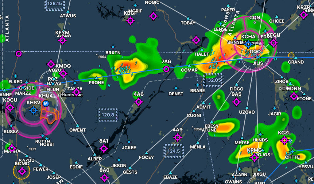
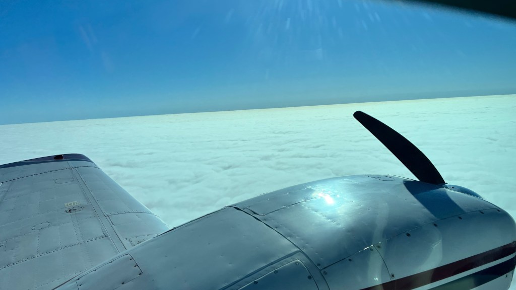
Later flights went much better. John led me through normal and short-field takeoffs and landings, in-flight engine shutdowns and restarts, single-engine landings, single-engine instrument approaches, and all sorts of failure scenarios. Thanks to smoke from western wildfires, I got a good deal of actual instrument time, and the sweaty Alabama weather made a great laboratory for seeing how the performance data in the pilot’s handbook translated to real-world airplane performance. As an example, the Travel Air can climb at just about 50 feet per minute with one engine on a hot day with two people aboard– 50fpm is a lot if you’re climbing stairs but it’s a recipe for meeting trees if it happens to you on takeoff and you’re not exceptionally quick.
During training we had a few assorted maintenance issues, as is common for rental trainers. The biggest was a 4-week wait for a new set of left engine control cables, which started about a week before my original checkride appointment. Factor in my work and personal travel, and John’s travel, and I wasn’t able to rebook my checkride until the beginning of November.
DPE Max Gurgew has a really good reputation in our local area, although I’d never met him. My first positive impression, from booking the checkride, was that he has a good web site that clearly lays out the required items and lets you request a time slot online.
I’d reserved the plane from 7a-noon on a Taco Tuesday, with the plan being that I’d pick it up at KHSV and fly over to KMDQ to meet Max. I got to the school at 0705 and…. no airplane. Despite calling the day before to confirm that it’d be on the line at 0700, and despite wearing my lucky shirt (“it’s a great day” on the front, “for tacos” on the back) someone had parked it in a far-away hangar, so I had to wait for the Signature line guys to go get it. By the time I was done getting the logs, having the plane fueled (which also was supposed to be done the day before), and preflighting, it was 815. I got a clearance, taxied out to 36R, started my takeoff roll and, oops, the door popped open.
ABORT ABORT ABORT, throttles to idle, stay on the centerline.
At least that was a familiar scenario. I taxied clear and wrestled the door back into position, called tower again, and took off uneventfully for 0.2 of flight time over to KMDQ. Easy normal landing.
Then the door wouldn’t open to let me out. That was fun. Eventually I got it unstuck and walked in to meet Max.
As his reputation foretold, Max was pleasant and engaging in person. We chatted for a few minutes, then started the review of my certificate application. (brief digression: any time you add a rating, you’re really reapplying for a newly issued certificate, which means there’s more paperwork than you might expect. The FAA uses a system called IACRA for certificate applications and, although no one likes it, we’ve all learned to work around its many quirks and misfeatures.)
This took a bit of time because I’d made a mistake on my application: for category/class upgrades, you have to fill in total flight time and pilot-in-command (PIC) time in the category/class. In my case, I’d gotten the PIC time field wrong, since you can’t log PIC time in a category or class where you aren’t rated unless you’re the sole occupant and have the correct endorsement. This took a few minutes to fix, then Max went over what we’d be doing on the checkride. He also asked me to sign a liability waiver, which I haven’t had to do on other checkrides (but it’s been a while since my last one so maybe this is more common now).
The oral exam was very straightforward. We started with a discussion of Vmc, the minimum controllable airspeed. Vmc is super important because if you drop below that speed, there won’t be enough air flowing over the rudder for you to maintain directional control. We discussed how manufacturers certify Vmc for an airplane (requiring me to walk through a discussion of SMACFUM), and the balance between controllability and performance. I used a whiteboard to discuss how the critical engine is determined (PAST), and we discussed the Vmc controllability-versus-performance table but he didn’t ask me to draw or recite it from memory. He quizzed me about various single- and twin-engine speeds and limitations, which was a weak area for me (e.g. I knew Vmc and Vyse but didn’t remember Vsse offhand).
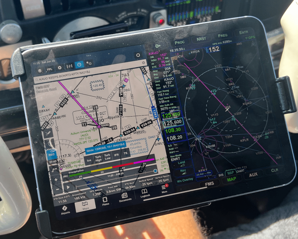
We covered some basic performance: what service ceilings are, what accelerate/stop and accelerate/go distances were for this plane (trick question: there’s no published accel/go for this plane, so I calculated that as the sum of accel/stop and normal takeoff distance over a 50’ obstacle under the given conditions). He then gave me a scenario: “you’re flying IFR cross-country from Huntsville to DC at 9000’ and you have an engine failure. What do you do?” In this case, the single-engine service ceiling for this airplane is 4400′, which means that’s the maximum altitude you can expect to climb to on one engine. Since there’s terrain between here and DC that’s higher than that, the correct answer was “get away from terrain and land ASAP”.
The systems discussion covered fuel (how many tanks, capacity, how does crossfeed work), landing gear (power system, emergency extension, sensors/switches, actuation), and propellers (how feathering works, how the prop governor in a twin differs from a single). Having flown the plane for a dozen hours or so meant that I had some practical understanding to go along with my book learning, which is exactly what the oral exam is meant to determine.
After a short break, we walked out to preflight. Wind was 12G20 but nearly right down the runway centerline, and sky conditions were 4500’ scattered. Max had prebriefed me on the sequence to expect. After a normal and successful preflight, I did a short safety brief (I’m the PIC, we will use positive exchange of controls when needed, alert me if you see/hear/smell anything funny/odd/dangerous, eyes outside), started up, and did a standard takeoff brief covering what I’d do in case of a failure before or after liftoff. I did a short-field takeoff to the north, followed by a long climbing turn to get around some patches of clouds, called KHSV approach for flight following, and climbed to 5500’ for maneuvers. We never got further than maybe 7nm from the airport throughout the maneuvers.
We started with slow flight, then power-off and power-on stalls, steep turns, and the Vmc demo. Even though I’d beat it into my head already, Max did me the favor of asking for clearing turns for each maneuver—so we’d fly a maneuver to the north, do a clearing turn to the south, then do the next thing, then back north, etc. After the Vmc demo, he had me demonstrate an in-flight shutdown of the failed engine, followed by a restart. I was following the checklist procedure, which requires use of the boost pumps, but he had me turn them off to avoid flooding the engine.
After the restart, we flew back towards the south to let the engine warm back up, then I demonstrated an emergency descent. In this airplane, you extend the gear below 130kts and pitch down for 130kts. That worked fine, until I recovered and retracted the gear. At that point, we both heard a Satanic grinding coming from the gearbox. (In this plane, the gear is driven by an electric motor, which drives a reduction gearbox, which drives a star gear linked to all the actuating rods– this video shows it in detail). I looked at him, he looked at me, we both made faces, and he said “Let’s see if we can put the gear back down.” We did, and we got a green light (this airplane only has 1 gear light, not 3, but there’s a nosewheel mirror), but we also got more grinding. My heart plummeted because I knew I was about to get the Big Disco.
See, when you’re doing a checkride, there are 3 possible outcomes. You can pass, you can fail, or you can get a “discontinuance,” which just means that you couldn’t finish the ride for some reason that wasn’t your fault… like demons possessing your landing gear. Think of it like pressing “pause”. You still get credit for anything you did successfully before the discontinuance… but the examiner can ask you to redo anything she wants to at any time, meaning that you could essentially have to repeat the entire test.
Anyway, with the gear down, he took the controls so I could brief the RNAV 36 approach back into KMDQ; about 5nm from the IAF he failed my right engine and I flew a fairly sloppy approach to a full stop. I think he gave me a few charity points here because although I was stable, I was just a hair under ¾ deflection above the glideslope until inside the FAF. In the debrief he pointed this out, and said that in a real-world situation it would be better to stay above glidepath if possible, but to keep in mind that doing so might make it impossible to get all the way down on a short or confined runway. Fair point.
After landing, I secured the plane and we debriefed. Once my MEI arrived, he ferried the plane back to KHSV; the school requires all maintenance ferry flying be done by their staff. Maintenance jumped all over the plane (I was climbing out the door when they hooked up the tug and started towing). They couldn’t identify anything wrong with the gearbox after an inspection and swinging the gear two dozen times, so they serviced it, put on two new main tires for good measure, and gave me the plane back.
I spent the rest of the day and the next morning fidgeting while waiting to see if I’d be able to fly again this week. A combination of weather, the DPE’s travel, my travel, and the airplane availability meant that I could either finish the ride in the next 5 days or wait until Thanksgiving week. Another instructor graciously gave up his reservation so I could grab a time slot late Thursday afternoon, with the caveat that weather might require me to take an MEI with me to fly over IFR, then work the pattern. Unfortunately, we had crap weather so I couldn’t fly that day, or for the rest of the week.
Cue annoying hold music. (In reality during that time, I had an amazing trip with Erica to Romania, which made the waiting significantly easier!)
On Monday, I flew with John again just to make sure I wasn’t rusty. The weather was beautiful and I flew well. The cool weather granted me the novel experience of actually being able to climb well on one engine. More importantly, Satan had left the area and the gear functioned flawlessly. I verified with the Revolution staff that the plane would be ready at 0630 the next morning and arranged to meet John there.
On checkride day, I rolled up to Signature at 0635; the plane was waiting, so I flew to MDQ and met with Max. After a few minutes of chit-chat, he quizzed me from memory on V speeds, asked a few scenario-based questions about performance based on the current weather, and then it was time to fly. We stepped out and did the remaining maneuvers: engine failure on takeoff, normal takeoff, normal landing, normal takeoff to an engine failure in the pattern and a one-engine landing, and a normal takeoff to a short-field landing. I flew really well. The debrief was short and to the point, he handed me my temporary cert, and it was time to fly home again.
A few specific items of gouge about Max as a DPE. Like every DPE there are specific things he wants to see.
- Don’t change airplane configuration until you’re clear of the runway and stopped. When you do, ask the PM to confirm that your hand is on the flaps (not gear) before you bring up the flaps.
- Do a takeoff briefing for each takeoff covering normal and engine failure scenarios.
- Do a runup on every flight, even if you just flew in from an airport 10nm away.
- During one-engine approaches, keep your hand on the good throttle as much as possible. This prevents you from accidentally moving the wrong throttle.
- Know power settings, not just speeds, for various phases of flight. I was embarrassed about this, since I use memorized power settings in my plane and never even thought to wonder about them while training in the BE95.
- Fly good and don’t suck. (OK, I might have added this one on my own.)
On to my CMEL next!