I’m going to start this post with an apology: I should have taken about a million pictures, and now I’m sorry I didn’t. Now, on to the good stuff.
RAM Aircraft is really well known in the airplane engine aftermarket. They make engine parts (under what the FAA calls “PMA,” or “parts manufacturing approval“), including entire crankcases, and they have a very well-earned reputation for high-quality engine builds and overhauls. They sell a variety of upgrades for different aircraft, sadly not including my model of Baron, and they’ve been in the business since 1976, which is pretty rare in the aviation market.
They’re also a service center, and one of the things they do is what they call a “service check.” Think of the service check like the 14-point service that your local oil-change place does when you bring your car in; RAM’s service check includes an oil and filter change (including cutting the filter open to look for contamination or metal residue caused by unusual engine wear), but it goes well beyond that. They remove and clean the spark plugs, check the engine cylinder compressions, remove and clean the fuel injectors, adjust the fuel metering system to factory specs, test the intake and exhaust system for leaks, and wash the engine. If you bring in a twin-engine plane, they do all that twice… and, of course, they can fix any problems they find.
RAM were generous enough to donate a couple of gift certificates for service checks to the American Bonanza Society. I saw one for sale on BeechTalk and that sparked an idea: RAM is in Waco, Waco is near Dallas, I needed to be in Dallas for work, and I needed an oil change. What a happy chain of circumstances! I called RAM to schedule a service visit for when I needed to be in Dallas, bought the certificate and planned my trip: I’d fly the plane to Waco on Monday, drive back to Dallas for my meetings, and then pick the plane up on Thursday.
My flight to Waco was perfectly uneventful but hotter than blazes– it was 104º when I landed, and even at 3000′ it was still above 90º. In my particular airplane, temperatures above 90º on the ground call for a few differences in takeoff procedure, and climb performance (especially on one engine!) is significantly reduced, so I had to bear both of those in mind.
I landed and taxied over to the RAM ramp, and after a short wait John Sartor, RAM’s customer service manager, came out to meet me.
My personal opinion: you will never meet a more friendly or pleasant person in the aviation industry than John. He immediately made me feel like an honored customer even though he’d just met me 5 minutes before. After a short verification of what work RAM was going to do, we went out for me to show him my plane only to find that it had already been towed into the RAM hangar. That was a foretaste of how efficient their operation is! After verifying that he had the keys and access to the plane, he drove me to the Texas Aero FBO so I could pick up my rental car and I was off to Dallas.
The next morning, John called about 815a. I first though “oh no, something’s wrong”… but no, he was calling to tell me they’d already drained the oil and wanted to verify what oil I wanted to use. Efficiency again!
A later call brought the slightly unwelcome news that some of my spark plugs were worn to the point where the RAM QA department wouldn’t sign them off as airworthy. Aviation spark plugs are very similar in design to the ones in your car, lawn mower, boat, etc., but because piston aviation engines use leaded fuel, the plugs can foul faster, and over time the electrodes can wear. The electrodes on a few plugs were worn past their limits. A less conservative shop would have put the plugs back in and said “hey, you should change these,” but the good news is that RAM had the plugs in stock and changing them had zero labor cost.
Thursday morning John texted me to say the plane was ready, so after work I drove back to Waco (stopping at In-n-Out on the way, since I’d missed lunch). When I got there, he was kind enough to give me a 90-minute tour of their entire facility. The tour started in the lobby, where they have cutaway models of three engines with all the rotating parts intact. Turn the prop, and you can see the crankshaft turn, the movement of cylinders, camshafts, and valves, plus movement of the oil pump, turbocharger, alternator, and other accessories. The machinework on the models is amazing, and it was really fascinating to see the parts of the engine I don’t normally see.
We then made the rounds: the order and processing department, accounting (where I paid my bill, yikes), and the various assembly, test, and disassembly areas. The most junior RAM engine builder I met had been there 9 years. The most senior had been there 34 years! The shop spaces were meticulously organized and clean; the parts and tools were clearly labeled to keep the right things in the right places, and overall the impression I got was of a smooth-flowing workplace where people are expected to take time to do the work properly and to spec.
Each rebuild starts as a cart full of parts, so when the builder starts work, all of the components required for that particular engine are already together. There are a number of interesting touches to the build process, including custom-made carts that let them roll the engine from the build area into the (small, scary) elevator to take it down to the test cells. Those were cool too– in the cells, they do the engine break-ins for you, using a water dynamometer instead of a propeller or “club”. When the engine arrives it’s ready to be installed and flown, with no further break-in required. Considering that properly breaking in a new engine is a tricky process, this is a valuable addition. At the end of the process, there’s a hallway full of beautifully painted, perfectly clean, freshly rebuilt engines ready to go back into service.
I hated to leave, because I could’ve poked around all day asking questions and generally being a nuisance, but it was already after 5pm and I didn’t want to be that guy. I shook John’s hand, preflighted the plane (which had been fueled by Texas Aero while I was on tour), and blasted off for home. As one does, I kept a hawk eye on the engine parameters but they were refreshingly normal, and I landed about a half-hour after a beautiful sunset and went home happily.
Summary: if RAM rebuilt the kind of engines my plane has, I’d use them; if they support your engine type, you should take a very close look at them for repair / rebuild services. They do good work and they’re good people.
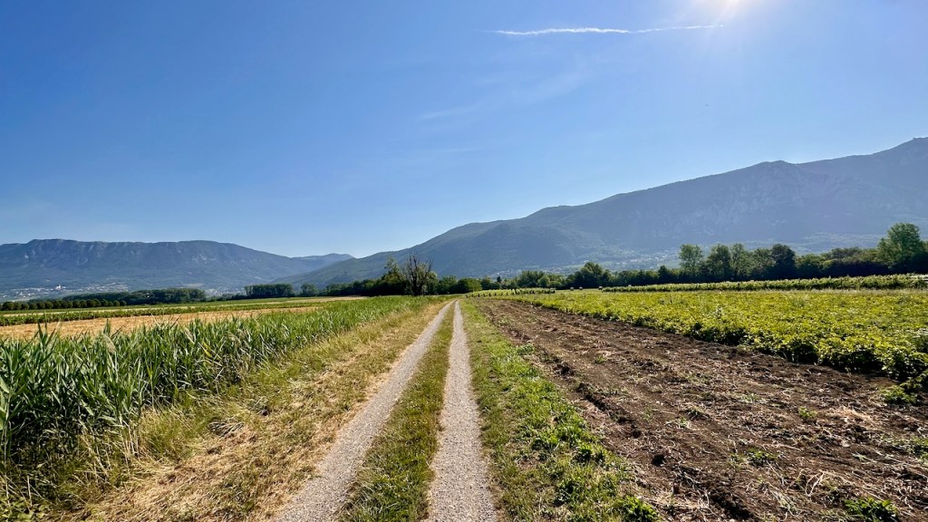
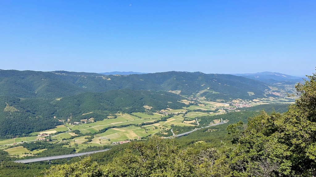
Do you like touring vineyards? Then this stage of the hike will be perfect for you. I think we saw every vineyard in this part of Slovenia, plus a goodly number of churches. (It seems like every single ridge in Slovenia has a church on top of it, which is certainly scenic!) This route had some decent hills, with a mix of shade and full sun; combined, I’d have to say the en route segments felt like a bit more of a slog but the views and breaks were well worth it.
After a delicious breakfast buffet at the Koren Apartments, we set out through the town of Vipava, walking past a grocery store, a small car dealer, and some other trappings of industral civilization that had mostly been absent on our other routes. It wasn’t long before we were off the road and crossing a meadow which led to… a vineyard.
representative vineyard shot– I honestly disremember if this was the first one we saw that day or not
nice sample of the day’s terrain
vineyards love hills
We climbed through the small village of Lože, then walked into the slightly larger and fancier village of Goče. Our directions encouraged us to wander through the village (“it’s impossible to get lost!” it promised), so we did, walking up the hill to the 17th-century cemetery (which features a lovely garden, a welcome water faucet for refilling, and a set of kid-size soccer fields across the narrow street), then back down to Saint Andrew’s church in the village. Like most of the churches we saw on this trip, it was closed and we weren’t able to go in.
St Andrew’s of Goče
After Goče, it was over (and up!) to Erzelj. Along the way, we made another detour, with accompanying climb, to the Church of St Maria of the Snow, which featured some terrific views back over the valley (and its vineyards) over towards Goče. The church is about a kilometer off the road, so the out-and-back added a little distance but it was well worth it.
We briefly stopped in Erzelj, which had some kind of government building, with a small playground next to it, and a smattering of houses. Like the vast majority of the other villages, we saw no signs of life– no people, no cars, no roaming pets, nada. We did find a faucet to refill our water bottles, so we relaxed in the shade of the playground trees, had a small snack, and then set out for the next leg to Tabor, where we got some great views from the old village church.
After that stop, we just walked a bunch more, passing through a few small sub-villages. We passed through Kodreti, which is where our stop for the night was: Hiša posebne sorta, which is Slovene for “a special sort of house.” The hostess warmly welcomed us and showed us to our room, where I promptly cranked up the AC and sat for a few minutes to cool off before a quick shower, a cold beer on their shaded terrace, and an excellent 3-course dinner of soup, pork stuffed with plums and cheese, and some kind of magical dessert.
It’s true that hunger is the best sauce, but it’s also true that every dinner we had on this trip was a highlight. Then to bed to rest up for the next day’s hike.
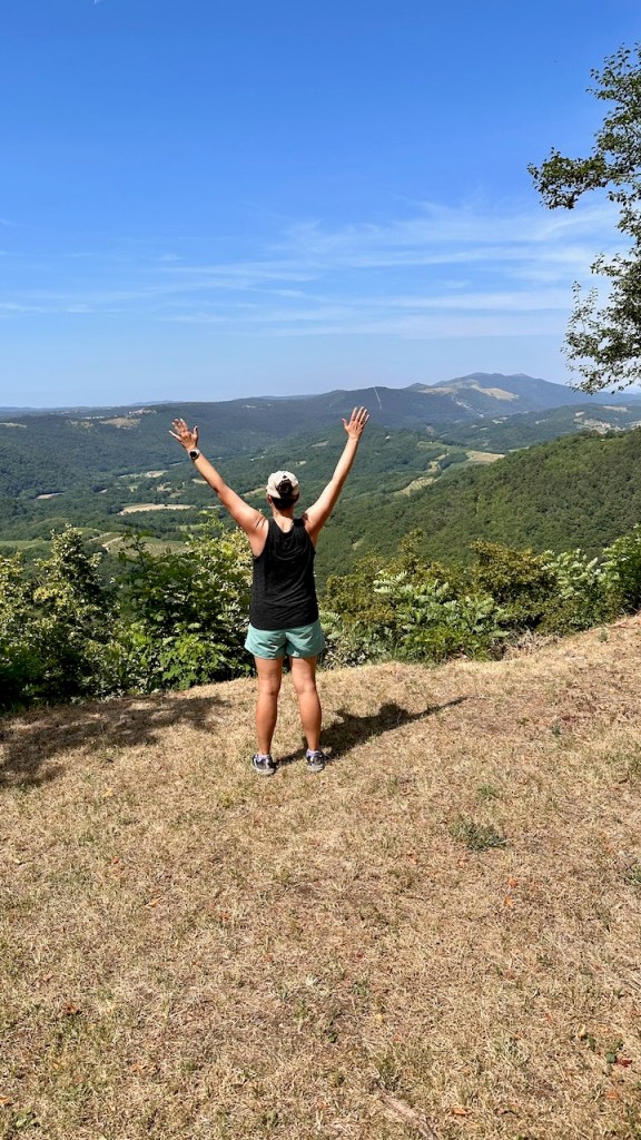
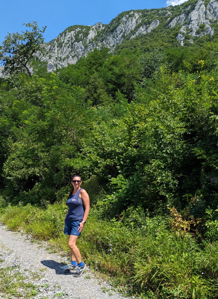
The big attraction of this day’s hike was the ability to climb up the ridge on Mount Nanos, which is actually a big limestone plateau and not a proper mountain. On one side it’s a huge mostly sheer set of cliffs, sort of like parts of Yellowstone, but those don’t photograph all that well with a cellphone camera. Here’s a small sample– note the exposed rock up at the top.
We didn’t climb all the way to the top, I regret to say
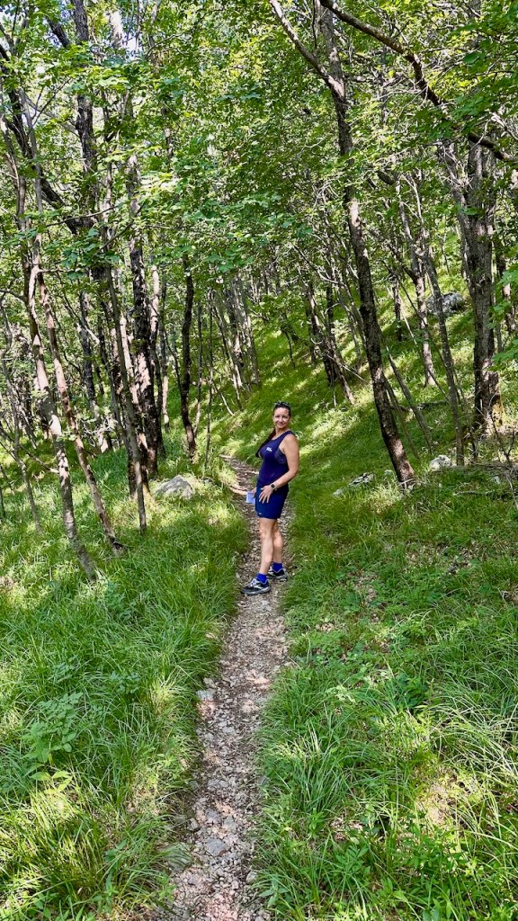
The hike started at a small church but, after a short walk to the trailhead, we were quickly headed uphill. We saw lots of people hiking down the trail, which explained the full parking lot at the trailhead. This made sense once we realized that it was still early and most of the hikers we saw had clearly gone out for a quick hike before it got too hot.
the initial trail was nicely wooded
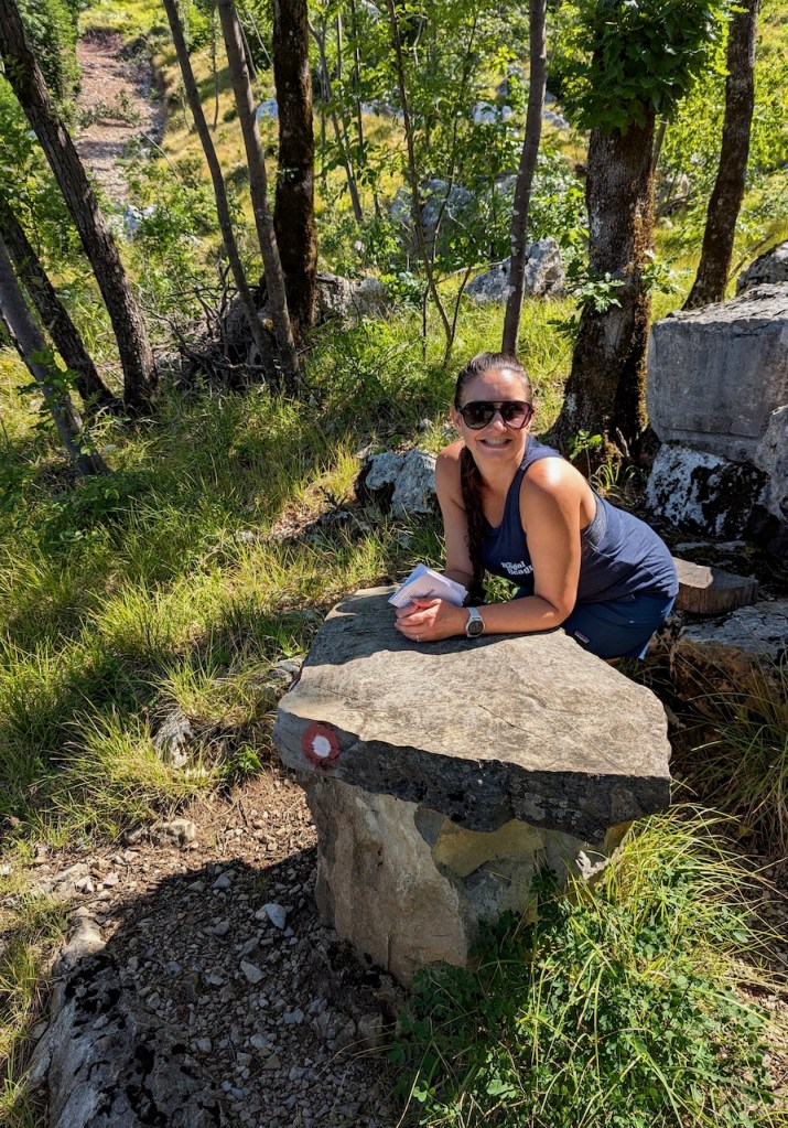
The route instructions called for us to climb up to one of the designated waypoints, then decide if we wanted the main route or the one that went up on the ridge for better views. The trail was marked both with yellow arrows and small red-and-white marks that look like the Target logo, which were super helpful, and the turn-by-turn directions were also very detailed.
gorgeous smile, but also, did you see that little red-and-white trail marker?!
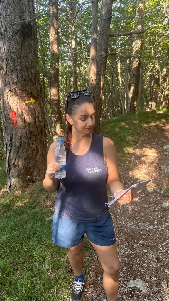
I was using the GPS map on my phone for route guidance, and Erica was cross-checking with the printed directions. This system worked pretty well for us, except in this one specific case. See, the directions basically said “for the main route, do X, Y, Z” for, oh, maybe 8 pages. At the end of that section, it then said “and if you want to climb the ridge, instead of Y, do P, D, and Q.” So we missed the turn onto the ridge route at first, and didn’t realize it until we were well along the main route.
Erica kept the printed directions handy
We didn’t notice because of two reasons. First was that we were hearing voices… really. Somewhere in the valley below is a motorsports track, and we could hear roaring engines and the track announcer. There was too much foliage alongside the trail for us to directly see the track but we could definitely hear it. The other is that the trail we were on was marked; I just didn’t notice the aforementioned split in the before/after directions until we were quite some distance in.
Luckily, the AllTrails map showed all of the trails in the area, not just the ones we were on. We found a side trail that angled off about 45º to our track and that joined the marked route for the ridge. This trail didn’t have as many of the trail markers as I would have liked, so we made a couple of wrong turns. Sadly, each of those wrong turns involved a steep climb, followed by puzzlement, swearing, and backtracking. Eventually we found the correct path, which linked up with the ridge route, and we got some of the promised amazing views.
off to the right is our destination, the village of Vipava
The path eventually ran alongside a small road, with lots of switchbacks; in one of those switchbacks we found a shaded bench to sit on for lunch. There I had one of the best lunches I can remember: there was a small water trough with fresh, and extremely cold, water, an amazing view shared with my lovely wife, and a delicious lunch consisting of farm-fresh fruit and sandwiches, on homemade bread, of local cheese, uncured ham, and… wait for it… donkey salami.
Yes, you read that right.
It was very tasty. Sorry, Eeyore.
Anyway, after an amazing lunch, it was back onto the trail. We moved into a more forested area, with the highlight being a stop at the Church of St. Niklaus, which dates back at least to 1608. We couldn’t go in, but I did manage to ring the church bells. At first I tried using a tree branch, but after a little research, I found the bamboo rod, with a convenient hook on the end, that was meant for bell-ringing, so I gave it a try. (annoyingly, I can’t make WordPress uncrop the video, the dirty rats. Watch it full-screen if you actually want to see the bells.)
Ring out, wild bells. Or something.
That probably isn’t allowed, so we fled the area fairly quickly, only to find out that we were in an old artillery range that used to be used by the Yugoslavian army back in the day. We didn’t think it was in time of shooting, so we pressed on.
This part of the trail was neat because to our right we had the sheer faces of Nanos, and between that and the trail were large fields of scree and gravel. Clearly rock had fallen down off the face and been weathered into smaller and smaller pieces before it ended up underfoot. You could see spots on the face where a large rock had broken off and fallen, then the fallen rock itself… sort of like those maps of Pangaea that show the primordial continent evolving into today’s arrangement. The path was mostly trending downhill, and soon enough we came out of the forest and found a lovely oasis in the form of Kamp Tura. This is, essentially, a Slovene KOA, with spots for tents or campers, a shower house and bathrooms, sports courts, and a nice little cafe where I drank two brain-freezingly cold Coke Zeros while we chatted with Bojena, one of the owners.
Pro tip: on the entire trip we found approximately zero public restrooms. That turned out not to be a problem because it was so hot that we didn’t need any pee breaks en route, but you should plan accordingly if you do this route in less-sweaty conditions.
After Kamp Tura, it was an easy downhill leg through some vineyards and past what looked like a Soviet-era industrial complex (but which turned out to be a winery!) before we got into Vipava itself. Vipava’s a real town, with a few restaurants and bars on the town square. On Foot had booked us into a very nice little tourist apartment; after checking in, cranking up the AC, and doing a little sink laundry, we headed out to try to find a wine tasting. The only problem is, the nearest winery was a couple of miles away uphill– and there are no taxis in or around Vipava. So that was right out. Luckily, the family that operates the apartments also runs a small winery, Wipach, and there’s a small wine shop on the ground floor. We had an amazing tasting hosted by one of the winery owners, a charming schoolteacher who runs the winery with her husband. She’s the grand-daughter of one of the winery’s two founders and her husband is the grandson of the other founder… so it’s absolutely a family concern.
After the tasting, we got cleaned up for dinner. Our apartment hostess had asked if we liked pizza; when we said “yes,” that’s what we were expecting. Instead…
what kind of soup is that? wrong answers only.
…she booked us a table at Gostilna Podfarovz, where we had an amazing dinner consisting of, well, I’m not really sure. The photo above is our soup: cucumber and zucchini cold soup with kefir on top, and some kind of little puffy thing with raspberry balls on it. There was a course of trout tartare and beef tartare; there was lamb; there were various other odd combinations of ingredients that I would never have ordered but which I was happy to eat. In fact, they fed us so much that we had to decline dessert. All throughout dinner we saw people walking by with ice cream, and we kept joking about how good ice cream would be before bed… except we just didn’t have room.
Full of lamb-trout-mystery-food, we went back to the apartment to make an early-ish night of it; the next day’s segment was going to be hilly and hot without a lot of shade so we wanted an early start.
Not surprisingly at all, we both woke up before the alarm– neither of us wanted to be late to meet our driver. Our B&B had the convenient feature of allowing you to pre-order breakfast, so promptly at 0730 we went out to the terrace and had an amazing breakfast of fresh-baked bread, local meats and cheeses, local honey, and locally-farmed eggs. This set the pattern for our hiking, where I can only think of one store-bought or processed item (a pot of fruit yogurt) that we were even offered. Plus, the coffee was delicious.
For this hiking route, On Foot had arranged a driver to take us to Landol, the first waypoint on our hike. We’d prearranged with the driver to divert and stop at the famous cave system at Postojna. To tour the caves, you ride an underground railway for 10 minutes or so, then take a walking tour through the cave system itself. I do love a good cave, and this one was fantastic– the cave system itself goes on for kilometers, as a result of the limestone terrain that’s easily infiltrated and undercut by water. As with our other cave visits, cellphone pictures don’t really do justice to the sights, so I didn’t take a lot of pictures.
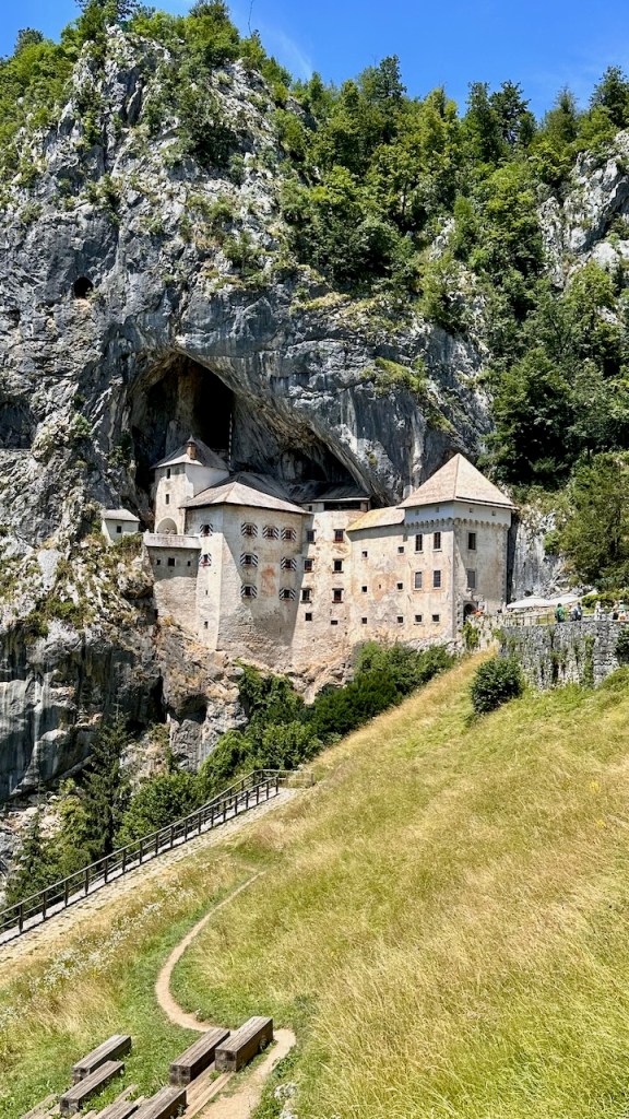
From our dropoff point in Landol, our first waypoint was the castle at Predjama, which was good because we both wanted to see it. Predjama is about 10km from Postojna and maybe 4km from Landol, so the first leg was pretty easy. Predjama literally means “in front of the cave,” and when you look at the pictures you can see why. The castle itself is built into the side of a cliff and extends into a pre-existing cave system.
Predjama is uniquely sited in the side of a cliff
The castle definitely has a tourist-y vibe; there’s an available audio tour, lots of placards, and some samples of armor, weaponry, etc. The presented history emphasizes the role of Erasmus, the robber-baron-knight of the area, which was a nifty story I didn’t previously know.
Rapunzel, Rapunzel, let down your hair… oops, wrong castle
After the castle visit, we had lunch at one of the restaurants– I had a giant schnitzel and a half-liter of Union beer, just to make sure I was getting enough salt, fat, and alcohol on board before the real hike started. Then… we started walking.
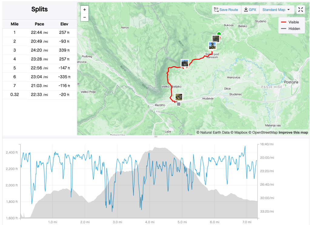
The hike itself was just under 7.5 miles, all over mixed terrain: some meadows, some wooded trails, some climbs, a few descents, a little gravel. The below route map from Strava should give you some idea; this was a relatively flat course that didn’t have a lot in the way of stunning views, but it did have some lovely scenery.
a quiet forested trail is good for the soul
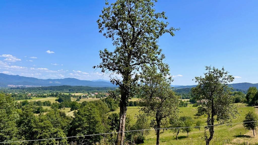
It was a lovely day to be out in the countryside
One thing the On Foot guide had prepared us to expect was the presence of monuments in each village. When you think “village” you may be assuming something larger than the typical Slovenian village– the entire country has only about 2 million people, half of whom live in Ljubljana and other cities. A village there might be no more than half-a-dozen houses clustered near each other, but I think every one we went to had at least one shrine, plus a monument to partisans killed resisting the Nazis in World War II.
Another welcome feature of the villages: they usually had someplace to refill our water bottles. Erica had gotten us a pair of collapsible LifeStraw bottles for our Belize trip, and they were perfect for this trip. We didn’t need the filtering, since Slovenian tap water is as safe to drink as in America, but being able to collapse them was handy. Our day pack weighed maybe 15 lb and contained the two LifeStraw bottles, an extra 1.5L of bottled water, our lunches, snacks, a small first aid kit, rain jackets, maps, and a few other odds and ends.
On the drive to Postojna, our guide said that Slovenia is famous for having more tractors than cars. I can’t assess whether that’s true but we did see rather a lot of tractors, including this beauty. We saw plenty of them, both parked in barns but also working in the fields.
After a pleasant, but hot, hike, we made it to Hudičevic, which means “the hidden devil.” There’s a local legend about a mean old washerwoman who was taken ill. As she lay on her deathbed, the local priest dressed up as the devil to try to frighten her into accepting last rites. Thinking he was the actual devil, she shot him. (coolStoryBro.jpg) Hudičevic is a tourist farm operated by the son and daughter-in-law of the original founders, the Simčič family, who opened in 1970 as an inn to feed the workers who were building the nearby motorway. The couple’s 10 kids all live and work at the farm, which was pretty neat. Our room was small and nicely furnished; although it didn’t have air conditioning, as the evening cooled it was quite nice. Dinner, and the next day’s breakfast and lunch, were all locally produced. Although the menu offered both donkey salami and horse salami, we decided to stick with more traditional fare. I had pork loin stuffed with cheese and plums, along with a thick vegetable soup and a delicious berry dessert with fresh homemade ice cream. Erica had lamb.
We both slept very well and enjoyed a fantastic breakfast buffet; whichever kid was working in the kitchen also packed us each a sack lunch, then Klara drove us into the village for the day’s route.
that wasn’t the mountain we climbed but it’s a decent stand-in
There’s no great way to get from Venice to Ljubljana by air or train, so I decided to book us on Flixbus. The bus left from the Venice central station, which wasn’t far from our hotel. We took a taxi after the first two city buses we wanted didn’t show up. When we got to the station, it was like being in an anthill– tons of people, all milling around in unpredictable patterns. I was getting a little panicky because the bus wasn’t anywhere to be found at the specified location, but we eventually found a queue of other people who were waiting for the same bus, and it showed up about 15 minutes later.
Pro tip: Italian train/bus stations have pay toilets. Take a couple of €1 coins, just in case.
For about €40, we had a clean, safe, quiet, and comfortable 3-hour bus ride. Both of us were surprised at how quiet the atmosphere on the bus was– much quieter than a typical commercial airline flight. Flixbus bought Greyhound in the US, which I didn’t know, so maybe “riding the dog” will come back. It’s hard to beat the price. When we arrived in Ljubljana, we quickly found our way to Pension Slamič, our lodging for the night. It was much nicer than I had expected– a modern, clean, quiet hotel only a few blocks’ walk from Old Town. After checkin, we headed out to see some sights and immediately fell in love with how walkable that area of Ljubljana is. Big, wide sidewalks, with bike paths and plenty of trees, make it easy to get around comfortably. We found a post office and bought some postcard stamps, then found a Spar and bought a few extra bottles of water for the hike. Because we’d missed lunch thanks to being on the bus, our first important stop was dinner at Patrón for tacos. This might seem like a weird choice but having tacos in foreign lands is kind of our thing, and I’m really glad we did it here. The fish taco I had was one of the best I’ve ever enjoyed anywhere, and the carnitas taco was as good as anything I’ve cooked myself. We enjoyed sitting out on the street and people watching for a while, then set out to go hit our major objectives.
wish I’d noticed how blurry this was before I ate the tacos
Ljubljana has (at least) two well-known bridges: the Dragon Bridge and the Triple Bridge. You can probably guess how they got their names…
here there be dragons
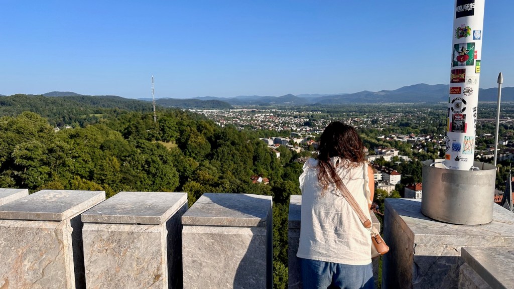
The old city itself isn’t that large, so we made a circuit across the bridges and then climbed the hill to the castle, which is a really interesting tourist-ized version of its former self. There are several exhibits and museums in it, including a really interesting section dedicated to Slovenian history, a topic as complex as you’d expect from a central European country that’s been passed around from empire to empire over the centuries. There’s a nice mix of original and restored structures and artifacts, and you can climb the clock tower to look out over the city.
the castle overlooks Ljubljana and the surrounding area
After our castle visit, we only had one more planned stop: the rooftop bar at the Nebotčnik. This was lively, even at 6pm, and we had to wait a few minutes for a table, but the views were worth it. I had some kind of cocktail which appeared to be a glass of Windex, and we split two delicious pieces of cake.
After our rooftop visit, we headed back to Slamič to make sure our day pack was ready for the following day’s hike, then hit the bed early.
Yes, that’s right… in one of the most romantic, most iconic cities in the world, we weren’t even staying in the fun part, and were in a chain hotel to boot. But before you get too out of sorts, consider that the stay was free (thanks to Hilton points) and that there’s a bus stop within about 25′ of the front door. At that stop, you can take a €1.50 bus ride for 10 minutes and be in Venice, or at the central station downtown, or at the airport, all of which we needed. Overall I was really pleased with the hotel, although it was absolutely jam-packed with tour and cruise-ship passengers. It was exactly what you’d expect from a Hilton property: clean, well-maintained, with decent amenities and a friendly, competent staff. We weren’t going to be there much anyway!
After dropping off our bags and a quick shower, we grabbed the bus to Venice and started, well, just wandering around. Let me stipulate once that it was super hot (88+ ºF) and very crowded the entire time we were in Venice. That way I don’t have to repeat it. Neither of us loves crowds, but that’s par for the course when traveling in Europe now. Anyway…
One of many bridges
Pretty much exactly what you’d think Venice looks like
Traffic, Venice-style
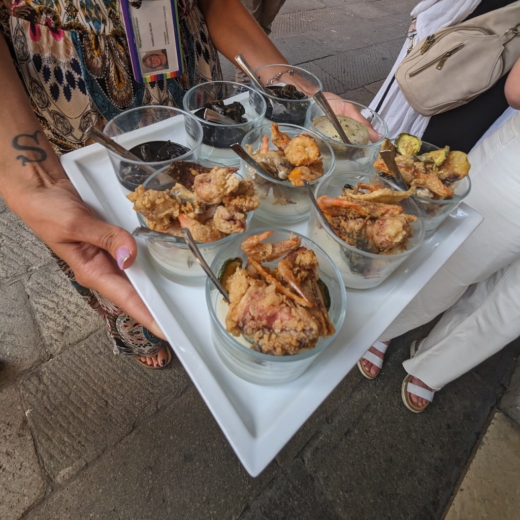
We didn’t have a real plan, so we just walked around. We managed to find some gelato for a mid-afternoon snack, as one does, and it was just as good as we both had imagined real Italian gelato would be. However, we had bigger plans for dinner– Erica had booked us a cichetti tour. If, like me, you have no idea what cichetti are, or is, or whatever: think “Italian tapas.”
The tour was superb. Our guide, Sylvia, was both a certified sommelier and an art historian; she moonlights as a tour guide. As we walked, she explained that Venetian nightlife centers around meeting your friends for small-plate snacking and drinking, in a sort of progressive-dinner style… thus the tour.
Sylvia with a tray of baccalà
Each of the places we stopped had a different specialty. At the first stop, we were served small fried-tuna balls, fritto misto (mixed fried seafood), and squid cooked in squid ink (not a favorite for either of us.)
fritto misto in the front, squid-in-ink in the back
At other stops, we had baccalà (shown above– basically, dried fish which is then boiled to make a sort of cream and served on toast; I liked it, but Erica didn’t as much); a sort of Uncrustable-like sandwich whose name I forget, risotto, and the best tiramisu I’ve ever had in my whole life. The risotto and tiramisu were at a place called Sepa, where I would 100% return if I were to find myself in Venice again. Each place served us prosecco, wine, or some other kind of drink, too. Our tour group was mostly Americans, along with an Australian mother-and-daughter pair, but it was fun to see the varying levels of adventurousness as we tried different types of cichetti.
I’m not normally a big tiramisu fan, but this was one of the best desserts I’ve ever had in my life, and I eat a LOT of desserts
By the time we got done with the tour, it was twilight, we were jetlagged, and we were stuffed full of food, so we headed back to the hotel (again on the bus) and called it a night. HAHAHAHAHAHAHA NO. What we really did was take the bus to the airport to get Erica’s suitcase, an adventure in forced wakefulness and Italian standards of customer service that I won’t detail here to spare your delicate eyes, dear reader. Then we went back to the hotel to sleep.
The next morning we bolted down a quick hotel breakfast and grabbed the bus again for what would prove to be a super full day of sight seeing. The weather had changed a little overnight– it was overcast and occasionally raining, but we grabbed our rain jackets and headed to the bus stop anyway. This turned out to be a great decision, because the rain kept a lot of the tourists off the streets (at least at first).
not about to let the rain… uh, dampen… our fun
I am told that this boat is a Venice landmark
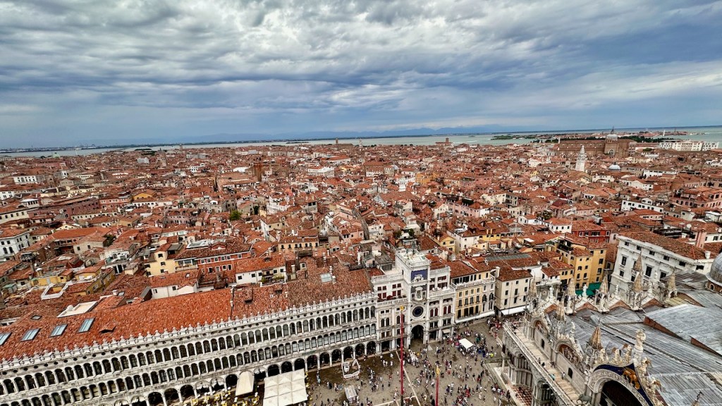
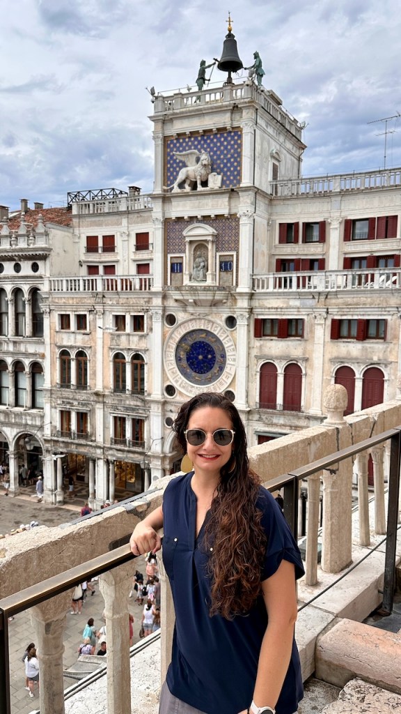
We had a very pleasant time just walking around but the rain intensified. Coincidentally we were near Ca’ Rezzonico, billed as the only museum dedicated to 18th-century Venice, so we went in to tour. It was fabulous! Paintings by Tiepolo, Tintoretto, and more; amazing frescoes; statuary; sumptuous decorations; and lots more. I didn’t expect to enjoy it, or find it as educational, as I did, and it hadn’t even made our short list of must-do items. We wandered around until we had seen everything we wanted to, then headed over to St. Mark’s Square, where we had timed tickets for the bell tower and the basilica.
Pro tip: St. Mark’s is always going to be crowded. Just mentally prepare yourself. It didn’t help that there was construction all over the place, but that’s also part of the price to be borne for being able to see centuries-old monuments in situ; sometimes they need maintenance.
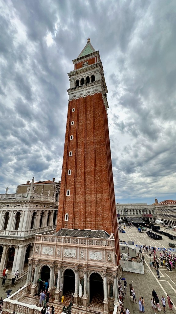
I didn’t take many pictures inside St. Mark’s proper, knowing that a cellphone camera wouldn’t do them justice. I did take several from the campanile and the balcony with the four horses, though.
well, OK, maybe just one…
The campanile from the outside
Pro tip: 100% do not go to St. Mark’s unless you have bought tickets with the “skip the line” option, in advance. Don’t count on tickets being available same-day.
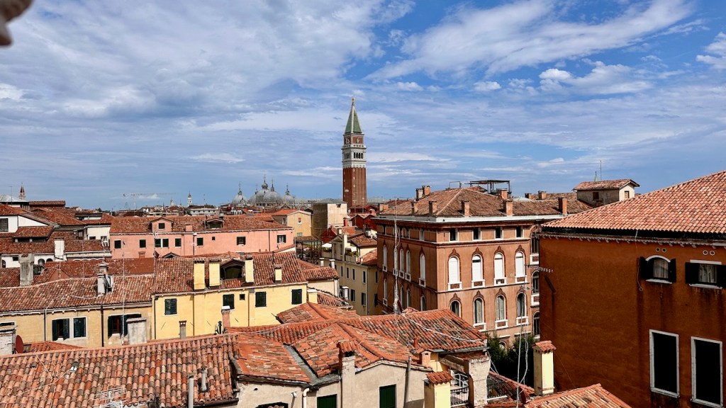
After St. Mark’s, we headed some distance away to have lunch. Erica had previously found recommendations for Osteria Alla Staffa, which was superb. The food was excellent and the service was warm, friendly, and fast. We chatted with a couple from LA who were in Venice as part of their honeymoon, and it was fun to compare notes. Then it was off to the Contarini del Bovolo (Italian for “snail”), where we had a 4pm ticket, for more unique views.
St Mark’s campanile from atop the Bovolo staircase
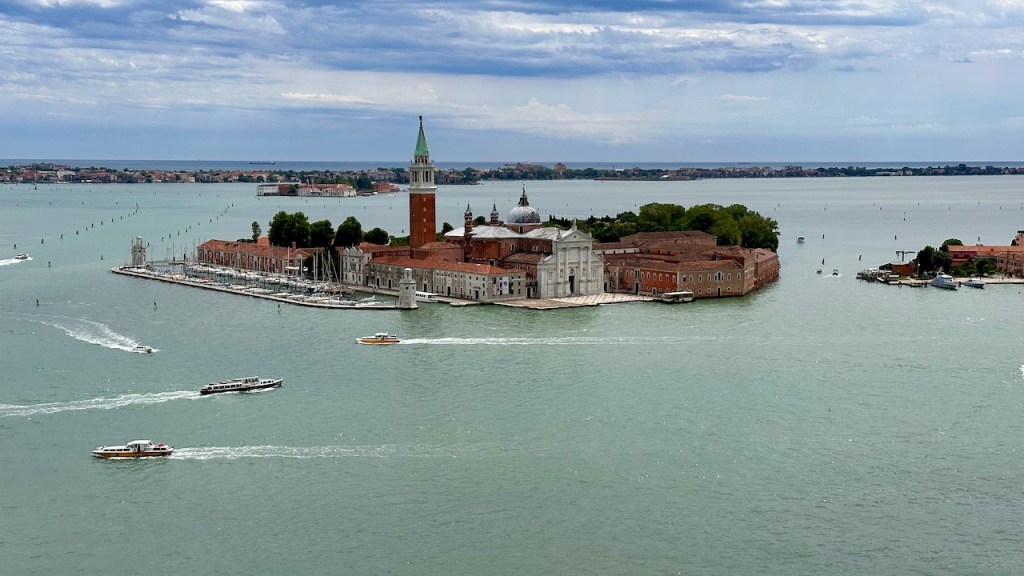
We hadn’t planned it in advance, but we decided to take a water taxi over to San Giorgio Maggiore. This requires us to go back through St. Mark’s, which was even more crowded than before lunch, then figure out which boat to take. Long story short, we took a bit of a detour to Giudecca before ending up at the desired spot. The views were very well worth it, though.
After another water taxi ride back to Venice proper, we stopped at a handy cafe for, you guessed it, more gelato. On the way back to the hotel, we decided to have a proper dinner, by which I mean “pizza,” during which we were serenaded by an honest-to-goodness accordionist. That was a first. The pizza was great though. Then we caught the bus back to the hotel to pack up and get ready for the next day’s trip to Ljubljana.
note the musician in the background
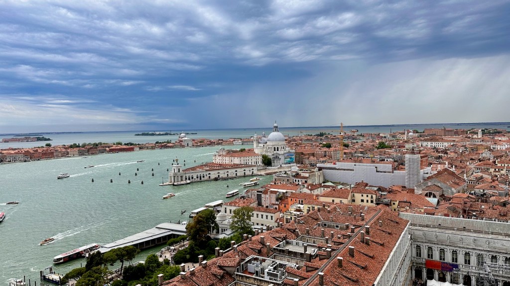
Venice has a view like this around practically every corner.
Erica and I do love a good adventure. After doing the Bermuda Challenge and Ragnar New England, we decided maybe it would be fun to have an active vacation that wasn’t focused on running. “How about a multi-day hike?” she asked me one day. “Suuuuure,” I said, envisioning a week-plus of sleeping in a tent (something I got my fill of in the Marine Corps). She did some research and came back with a terrific suggestion: On Foot Holidays, a UK company that arranges cross-country hikes with lodging at each point. In particular, she suggested we look at their route in Slovenia, which covered six nights starting in Ljubljana and ending in Trieste. This was especially attractive since neither of us had been to either Italy or Slovenia before. Each day was a separate point-to-point hike, with lodging arranged, and On Foot would handle moving our luggage for us.
We signed up and started digging into the logistics of traveling from Huntsville to Ljubljana. Let’s just say that the process wasn’t entirely straightforward. Erica had built up a great stash of Chase Ultimate Rewards points and wanted to use them, so she started hunting for flights. We ended up with great points deals to go from Miami to Venice on Air France, and from Venice direct to Newark on United. I booked Delta mileage tickets from Huntsville to Miami and from JFK back home, and then the real fun started. First Air France cancelled the Miami-Paris leg and moved it a couple of days, so I got to call AF and get that all straightened out. That change necessitated changing our Delta flights too, but when the dust settled, we had a fairly simple Huntsville-Atlanta-Paris-Venice routing.
On Foot provided us a thick packet of maps and guidance well in advance of the trip. Each day of the hike had its own topographic map and printed set of very detailed turn-by-turn directions, along with a summary itinerary telling us where we’d be staying and what to see/do in each location and a detailed packing list. They also gave us a single GPX file that had all of the GPS routes in it (more on that in a future post!) The On Foot team communicated frequently and clearly throughout the pre-game process, including assigning us a local contact that we could use if we got lost, stuck, or puzzled. That left us free to concentrate on planning the Venice and Trieste stays, since we could trust that On Foot had arranged lodging and food. As usual, Erica did an amazing job of identifying things we might want to do and organizing and arranging them. We had nearly two days in Venice on arrival, followed by a day in Trieste and two more days in Venice after the hike, and that led to a jam-packed schedule of things to do, see, and eat.
Our travel started out as completely unexceptional. The friendly Delta ticket agent figured out that he could check our bags straight to Venice even though we had separate Delta and Air France tickets; once that was done, we flew to Atlanta, had a snack at the Sky Club, changed planes, and settled in for the long-haul flight to Paris. The flight featured a toddler in the row in front of us who cried, whined, and, at one point, spit a mouthful of cracker over the two of us. It was just exactly as much fun as you’d expect, but we got to Paris undaunted, changed planes again, and then arrived in Venice.
Delta had a large, and rather patriotic, display in the Atlanta Sky Club
Of course, when we got to Venice, only one of us got a suitcase. We’d checked two bags. Mine went from Huntsville to Atlanta to Venice, all on Delta flights. Erica’s went from Huntsville to Atlanta to Paris to Venice, also all on Delta flights. Notice that we didn’t take those flights. Why did our bags take different flights from us? Why were they different from each other? Heaven knows. We filled out the you-lost-my-bag form, stood in an interminable line, and learned that Erica’s bag would arrive that evening but after the cutoff for bag delivery, meaning that if she wanted it that night, we’d have to go back to the airport to get it. Resigned to that fate, we grabbed a cab to our hotel to get ready for visiting Venice proper…
(note: this post contains no jokes about Boston accents or use of the word “wicked.”)
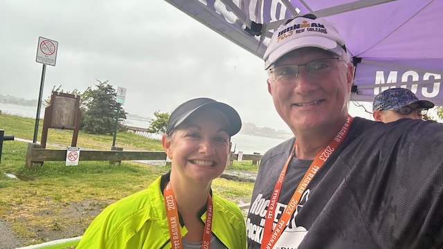
Back in 2017, I ran my first long-distance relay race, American Odyssey. Then this year, I did it again. Instead of Gettysburg-to-DC, this route was from Groton, CT to Quincy, MA, but it featured some of the same players.
See, what had happened was: Erica and I were just finishing our beer 5K and she got a text from her friend Kim, who’s captained multiple Ragnar teams before and got our team recruited into American Odyssey. She had some openings for Ragnar New England, and were we interested? Erica certainly was, but I had a business trip to Copenhagen planned that weekend. However, a little poking around on Google Flights showed that I could combine the two, so off we went.
Ragnar races are typically about 36-hour events. The team size can vary, but it’s most common to have a team of 12, divided into two vans of 6 runners each. Each run leg varies from about 4 miles to 7 or more; the idea is that runner 1 from van 1 runs, and van 1 drives to the exchange point at the end of that leg. When runner 1 arrives, runner 2 starts out, and so on. While 1 van is running, the other can be sleeping, sightseeing, etc.
Van 1 consisted of team captain Kim and her husband Tim, plus multiple-Ragnar veterans Travis and Ciri Corbin and their son Devin (another multi-Ragnar finisher), an active duty airman. Van 2 was me and Erica and two other couples from Huntsville, Megan and Zach and Amanda and John. I knew Amanda, and Erica knew Megan, and Amanda, John, Megan, and Zach all knew each other.
We arrived in Boston on Thursday midday and Kim and Ciri picked us up at the airport. Kim had arranged an Airbnb in Plymouth with enough sleeping space for the 11 of us, so after a quick stop for a sandwich and a beer, we headed to the house to drop off our bags. Some teams sleep in their vans but that just sounds (and smells!) terrible. The house was terrific– big kitchen, 4 bathrooms, 6 bedrooms, a hot tub, and full-size arcade games in the basement. Better yet, it was located so that the van that wasn’t running could drive there in a reasonable time between legs.
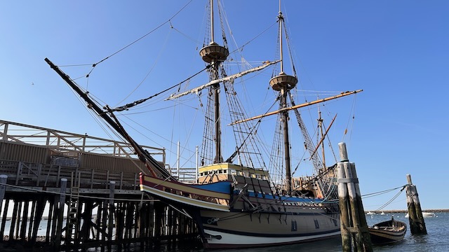
After the bag drop, we walked around Plymouth proper, including visiting Plymouth Rock (which is a lot smaller than I expected) and taking some pictures of the Mayflower II, a full-size replica that is still terrifyingly small.
The Rockets in our Pockets team, minus Devin, plus the Mayflower II
Imagine crossing the Atlantic in that thing
Kim had booked us dinner at a nearby restaurant, which was great for team socialization.
This time Ciri got to have selfie-arm and stand out in front
Of course I had to have lobster, in this case a delicious lobster mac-and-cheese. Extra credit to Sea Dog Brewing for their blueberry ale and their hilarious logo. Both the beer and the entree were delicious.
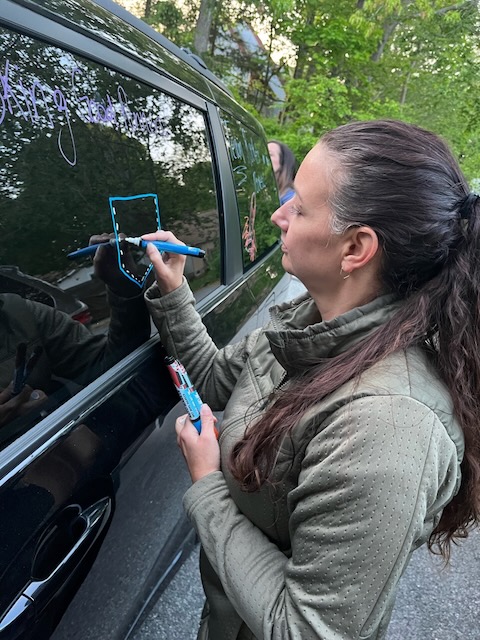
It’s traditional to decorate team vans, so after we walked back to the house, we got started on that. Our van was labeled “VAN HALEN” across the front (team 1 was “VAN MORRISON”) and then we started adding random pictures and text, each according to our own artistic abilities.
Megan is really excited that I’m writing “Слава Україні!” on the van
Erica carefully drawing the Rockets In Our Pockets logo
After the decorations were finally done, we all trooped off to bed. The race start was 9a Friday for van 1, but the start point was about a 90-minute drive away. Van 2 needed to be at the exchange point (“exchange 6”) around noon to check in, pick up our road-safety flags, and stage runner #7 (that would be me) for the run leg. This gave van 2 a little extra leisure time, but we’d be paying for it overnight Friday.
nearly the full team, including Kim’s rocket costume, at exchange 6
We met up with everyone at exchange 6 and checked in. You may notice in the picture above that we’re missing someone– that would be Travis, who was out running leg 6. As soon as he came in, I started out on my first leg, which was #7 overall. Because the race segments are built around 12-person teams, I also had legs 19 and 31. Erica got to be our anchor runner, so she had 12, 24, and the finishing leg, 36.
The exact start time for each subsequent leg would vary according to the runner’s pace; Ragnar provides a pace calculator sheet but it was pretty quickly evident that we had some sandbaggers. Both Devin and Zach ran much faster than predicted, and most of the rest of us were a little faster (at least on some legs). Shout out to Kim for being precisely on her predicted pace, even though she ran double legs to make up for us being one runner short.
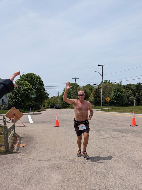
My first leg started at Misquamicut State Beach in Rhode Island and covered a little over 7 miles. I ran right on-pace and enjoyed the sunshine enough that I took off my shirt about halfway. It was mid-60s with a nice breeze– the perfect weather for a leisurely run along the coast.
it feels good to be a gangster
After I tagged our next runner out, we went in search of lunch, first stopping for a quick coffee pickup at one of the ubiquitous Dunkin Donuts found everywhere throughout New England. Rural Rhode Island isn’t exactly overrun with restaurant options, and we didn’t have a lot of time, so we found a small grocery store with a deli and bought sandwiches, then ate them in the van while heading to the next exchange point.
van #2, on the go to pick up Zack
This pattern continued until we met up with van 1 again at exchange 12– Erica finished her leg, tagged Tim with the relay wristband, and then the rotation started over. That left van 2 free to go back to the house; we had about 3.5 hours before the projected start time for my next leg, but about 1.5 hours of that was eaten up by driving from exchange 12 to the house. When we got back, after a quick shower, I went immediately to sleep with an alarm set for 1120pm. When it went off, I blearily got up, got dressed, and met the team in the kitchen for our departure to exchange 18, where I would start on leg 7.
If you haven’t ever run in the middle of the night, let me tell you… it’s weird. It’s not just the darkness, nor the reduced activity in your surroundings. At least for me, it’s like my body knows it’s supposed to be asleep and just acts uncooperatively. My leg started at a middle school and ended at a high school, which meant I was running through mostly neighborhoods. The night was quiet, still, and cool, and in some spots the only real light was what was coming from my headlamp. It was a little spooky. After my exchange, we continued through the night, with Erica taking the last leg that finished a little after dawn.
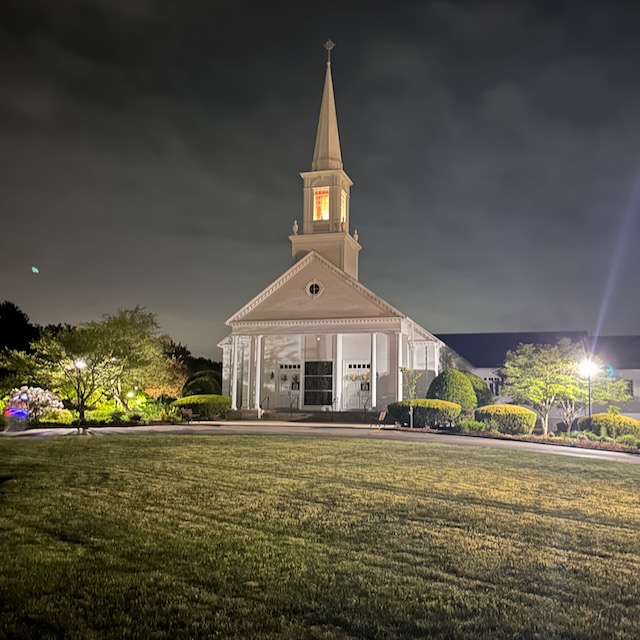
one of our exchanges was this lovely little church
After Erica finished leg 24, we loaded up the van for the short drive back to the house. Because our team had put another ~30 miles on the odometer since the start of my leg 19, we were quite a bit closer to the house. After another turbo shower, I was sound asleep until the alarm went off, at whatever time that was, and we loaded up for the drive to exchange 30. That whole process was a little bit of a blur.
Unsurprisingly, my third leg was the most difficult– I was tired, of course, but it was also hillier than either of the first two legs, and I didn’t love the course. For much of the 7 miles, I was running on the side of the road with no shoulder or sidewalk, with lots of hills and blind curves. There were some fun sights to see en route, though.
but why?
the real ones know
moments of beauty and tranquility in the midst of all the sweat
After the exchange, we found a small coffee shop for breakfast and went on with our pickup routine. The skies continued to darken and it became clear that it was going to rain– the forecast had called for rain after 3pm, but the forecast time of the rain’s start varied throughout the weekend. The bottom line is that our last three runners got rained on, and poor Erica was inundated. She had to run the finishing leg in a hard, steady, chilly rain, and she did it without a word of complaint. This didn’t surprise me, since she’s the same athlete who ran the last leg of American Odyssey on a bothersome knee in 85° heat, but I was proud of her.
Finally, the finish… I wish I could write about how great the finish-line ceremony was, but it was lame. Because it was still raining heavily, there were no spectators; every team that had already finished got their medals and took off. There was no free food or beer, as promised (I guess the vendors took off?) but we didn’t mind, because we didn’t want to hang around anyway.
that’s one for the books!
the idea of a waterside finish was great, but the implementation, not so much
Instead of going out to celebrate, we made the consensus decision to order pizza. This turned out to be a brilliant choice– everyone had time to get a hot shower and dry clothes, plus hot tub time, and then we sat around visiting and eating pizza. I don’t think anyone stayed up very late; Erica, Tim, and Kim had early flights on Sunday, and I carpooled with them since I was flying to Copenhagen later. I figured I could drop my luggage and go see some sights.
As it turns out, Sunday morning is a terrible time to see sights in Boston because things are either closed because it’s Sunday or closed because it’s early. For example, the Old North Church has services all morning, so you can’t tour it; the Boston Fire Museum is closed, and so on. I walked around a bunch in the sunshine, had Mexican street cod at Legal Sea Foods, and then went back to the airport for my flight.
Overall, the race was a blast. I got to meet some interesting and fun people, listen to some great new music (thanks to John and Zach), run in some places I hadn’t been before, and have yet another adventure with my favorite adventure partner. All in all, a great weekend, and I’d do another Ragnar with this group any time, anywhere.
Erica and I had planned a trip to visit Belize in March 2020. This, obviously, did not happen; we tried postponing it to December 2020, which also didn’t happen. We postponed a couple more times and then decided to “do it later.” Well, now it’s later.
Getting there was fairly straightforward: Delta flies to Belize City, and they had frequent-flyer seats available. It’s about a three-hour flight from Atlanta to Belize City, with one flight per day. We booked tickets and then started on the detailed planning– 90% of which Erica did– for a weeklong trip. Our flight down was uneventful and we arrived in Belize City about noon. Delta only operates a 737-800 on this route, so it’s not fancy by any means. The airport is small and noisy, with lots and lots of duty-free space relative to its size. (Liquor is expensive in Belize, so if you’re a heavy drinker, stock up at the airport.)
We’d booked a shuttle to take us up to San Ignacio, close to the border with Guatemala. It was US $120 and a roughly two-hour drive; for the first hour, there’s not much to see, but it gets more interesting as you go further west. Erica had used a stash of Chase Ultimate Rewards points, which she transferred to Hyatt, to book us at the Ka’ana in San Ignacio, a small but extremely nice resort that served as our base for the first part of our trip. The resort is about a 5min drive outside San Ignacio proper– a little too far to walk. It’s beautifully landscaped, with about two dozen rooms laid out around a central area with a pool and a combined reception/bar/restaurant. There’s a helipad (seriously… but don’t get too excited, it’s a stone “H” laid into a grass field) and a small organic farm that provides much of the produce used in the restaurant.
After checkin, we hit the pool, which is small but lovely, and ordered a poolside lunch. Spoiler alert: the pool has iguanas, and they will steal your lunch if given the chance. We saw the first iguana as we lounged, but as soon as the food came out, there were suddenly more of them, and they weren’t shy at all about climbing on tables or lounge chairs. Erica eventually finished her sandwich in the middle of the pool to keep it safe from their depredations.
this guy was not dissuaded by being threatened with a flip-flop
Dinner was at the hotel restaurant, which was oddly empty– there were only 2 other couples dining. We ate there each night; as you’d expect there were a few staple dishes (grilled stuffed chicken breast, various steaks) and some daily selections. All of them were quite good; none of them were so good that I’d rave about them here.
The next morning, we were up early for breakfast. Our room included continental breakfast, which you can pre-order, but the selections were a little different than a US hotel: oatmeal, sure, and a fruit plate, but also what the hotel called johnnycakes but what an American would call biscuits, served with delicious local cheese and refried beans.
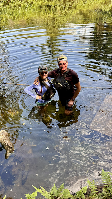
Breakfast delivery meant we had time to eat before leaving for our tour of the Actun Tunichil Muknal (ATM) cave, which we’d booked with MayaWalk. They picked us up from the hotel, and after a short wait at their office in San Ignacio we met up with the rest of our group and headed out on the 45-minute drive to the cave.
Summary: ATM is an amazing experience. It was made all the better by our guide Magdaleno, who was both knowledgeable and passionate about the history of el mundo Maya. He did a fantastic job of explaining the significance of the artifacts and remains in the cave itself, outlining what is known (versus what’s conjectured) about Mayan culture and civilization, and guiding us through the cave. The tour itself starts at a parking lot, where after a very short walk you ford a chest-deep river.
Crossing the river at the start of the ATM tour
Getting to the cave entails two more shallow river crossings and about a 1.5mi hike on a mostly-flat, mostly-dirt, mostly-shaded path. Once you get to the cave, you swim in and the real fun starts.
This is where you swim into the cave
We’d read tons of reviews of the cave experience, many of which highlighted how difficult it was. In reality, though, it was about a 5 on a scale of 1-10 for us. There was some climbing on and over rocks, and a few tight passages that required gyrations and contortions, but all easily managed. We saw one small clutch of roosting bats and one really impressive spider, plus all the usual beauty and grandeur of a large cave system. What sets ATM apart is its history as a sacred ceremonial space; there are multiple sets of human remains along the path, along with lots of ceremonial pottery. The tour culminates with climbing an extension ladder to the Cave of the Crystal Maiden, which is an unforgettable sight that unfortunately I couldn’t capture on my own. Cameras aren’t allowed in the cave because of damage caused by prior clumsy visitors, so the cave pictures we have come from MayaWalk’s archive. There are other restrictions (part of the tour must be done in socks, without shoes, for example) but nothing onerous.
After the tour, MayaWalk had catered a lunch of stewed chicken, rice, and beans, which we eagerly ate before the ride back to the hotel. Then it was time for another visit to the pool, as one does. Because of Erica’s status with Hyatt, the hotel offered to upgrade us a slightly nicer room that had its own private patio and tub, so we moved our stuff over and unpacked our $5 Walmart pool floats for the afternoon before enjoying dinner in the hotel again.
Our upgraded back deck
What did we do the next day? Not a darn thing except floating in the pool. I read two books, took pictures of some birds, drank several local beers, watched the iguanas, and generally just relaxed.
The hotel had a pretty good assortment of local birds to watch, including this collared aracari.
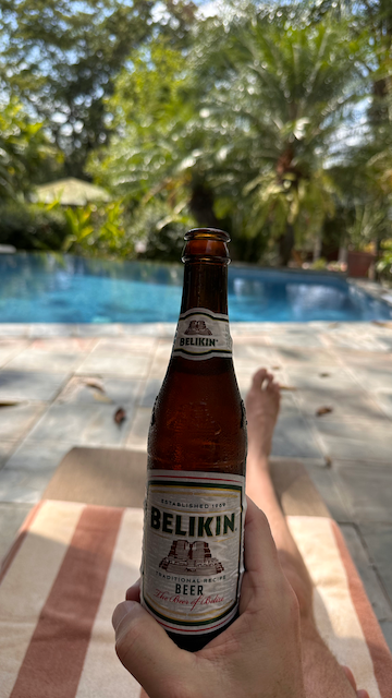
The two predominant local beers are Belikin and 501. I liked both, but liked their stout better than their lager.
OK, so maybe I wasn’t only looking at the birds, but can you blame me?
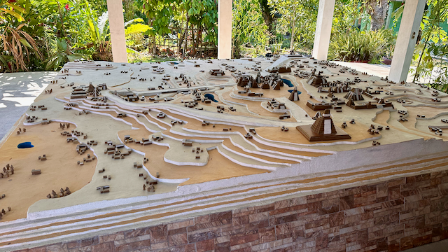
Wednesday morning we had an earlier wakeup so that we could take a tour of the ruins at Tikal. This required more driving than ATM, so we needed an earlier start. The MayaWalk driver picked us up as before and took us to the office to meet up with our group, and off we went. It was just us and one other couple (two lovely Brits now living just outside Quebec City). We made one stop en route at a local shop, which had a pretty impressive scale model of the Tikal complex. The model below shows the full extent of the complex, but not all of it is visible when you get there– more on that in a bit.
scale model of the Tikal complex as it might have looked when inhabited
The total drive there took about 90 minutes. Part of it is inside the boundaries of the park; you pass through a big gate that looks, no kidding, much like the famous gate from Jurassic Park. After we parked, we started exploring the complex. It covers an area of about 16 square kilometers; as you walk through on the provided paths, you can see the tops of some of the larger buildings, but many of the smaller buildings just look like tree-covered mounds.
as you walk through the complex sights like this are common
This is on purpose; if you remove the trees and vegetation from these structures, you’d also be removing some of the support that holds them together, not to mention exposing them more to erosion and water damage. The complex has been thoroughly mapped using both radar and lidar, which is where the layout in the diorama above came from. Some of the structures are open to the public, including Temple IV and most of the complex known as the Mundo Perdido (“Lost World”).
view from high up in the main plaza
view from inside a dwelling room, featuring the characteristic triangular “Mayan arch”
you can’t really judge the scale of these monuments until you’re there
It’s pretty astonishing to wander around the complex and picture the amount of effort and knowledge that went into building these structures: all by hand, with very limited tools, in a place with no nearby rivers or lakes (so limited supplies of water). There was a lot of specialized knowledge involved, too. Our guide told us the story of one structure that was restored by a team from the University of Pennsylvania but that had to be re-restored– the UPenn team made the structure too straight and level, so it was eroding much faster than expected because rainfall pooled instead of running off the side of the uneven original structure.
The tour took about 3 hours all told, then we piled back into the van for the trip back. En route we stopped at a restaurant, where we’d stopped on the inbound leg to preorder lunch. My plate of barbecued chicken, rice, and beans was simple but delicious. As with the inbound leg, we stopped at the border to walk through the customs checkpoint, which entailed having our passports checked and stamped. Since we’re both used to clearing customs and immigration at airports, this was a mildly novel experience but nothing too exciting. Once we got back to the hotel, we enjoyed a pleasant evening at the pool and a tasty dinner.
Saturday morning we got up, packed, and caught the shuttle we had booked back to Belize City. Our driver, Lucy, was a great conversationalist and told us all about life in Belize (summary: go to Guatemala if you need surgery; don’t trust politicians; if you want to live in Belize, rent before buying). Our destination was the water taxi terminal at the southern end of the city, where we wanted to take a water taxi to Caye Caulker. Tickets were around $20 each, and after a short wait we boarded the water taxi for the ride.
(Intermission: let’s talk about dollars. Belize uses the Belizean dollar (BZD), which is pegged at a 2:1 exchange rate with US dollars. Some places show prices in USD, but most are in BZD. We found that USD was accepted everywhere, and most places would accept USD and return change in USD. Lots of places don’t take cards, and none of the places we went to throughout the whole trip would accept American Express.)
The water taxi ride took about 45 minutes and deposited us at the tiny terminal at Caye Caulker. Luggage handling is a bit of a mess– the ferry was too full for us to carry on our small luggage, so we checked it; after arrival we had to wait for 45min or so for the luggage to be unloaded and sorted out. This was made less pleasant by the stink of rotting seaweed. At the moment, Caye Caulker’s eastern shore has been collecting an unusual amount of seaweed, which mostly sits there in the sun and decomposes. Crews come and shovel it away every so often, but not fast enough… thus the smell.
Apparently every vacation spot in the Caribbean is legally required to have a decorative sign
Caye Caulker is not a large island– it’s long and narrow, so you can easily walk from the western side to the eastern in five minutes or so. We’d booked at the Colinda Cabanas, and I can’t say enough good about the property– easy to get to, quiet, clean, with a small but very pleasant waterfront and beach area. Our bungalow was set towards the back of the property, with a small front porch with a water view. It was small but neat on the inside. Like Ka’ana, they provide filtered bottled water, which is important– I did get a touch of Belize belly at one point, probably due to ice cubes, and it wasn’t a whole lot of fun.
I loved the Belizean hardwood ceiling and trim
One of the reasons we wanted to visit Caye Caulker was its laid-back vibe. San Pedro is larger and more like a mini-Cancun, but Caulker is super slow-moving. In fact, “Go Slow” is their official island motto, and people take it seriously. There are no cars on the island, which is fine because you wouldn’t need them anyway. Instead, there are golf-cart taxis, plus lots of bikes. Colinda included two bikes with our cabin, but we didn’t use them because it was easy enough to walk. There are plenty of restaurants and bars, and a few shops. Interestingly, most of the grocery trade in Belize is controlled by Taiwanese immigrants, so you’ll see lots of grocery stores with Chinese surnames or poorly translated English phrases.
At the north end of the island, there’s an area known as “The Split”; in 1961, when Hurricane Hattie blew through, the storm surge washed away part of the island, leaving a ~100′ wide channel. We mostly stayed on the south part of the island. The Lazy Lizard is a famous bar right at the Split, and we walked past it a few times, but it looked like the kind of loud, heavy-drinking stupidity that we generally avoid. We did take a ferry across to the north side one afternoon to hang out at a secluded beach; the hotel on site is closed but they’ll still sell you beach access for BZ$10, which was well worth it.
Caulker has a reputation as a cheap destination for backpackers, and there were plenty of ’em. However, overall the island wasn’t nearly as busy as I expected. It is more busy during the summer. One note: lobsters aren’t in season until June so we didn’t get to have any. #firstworldproblems
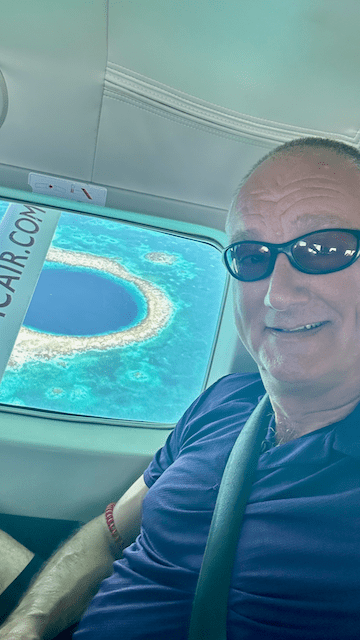
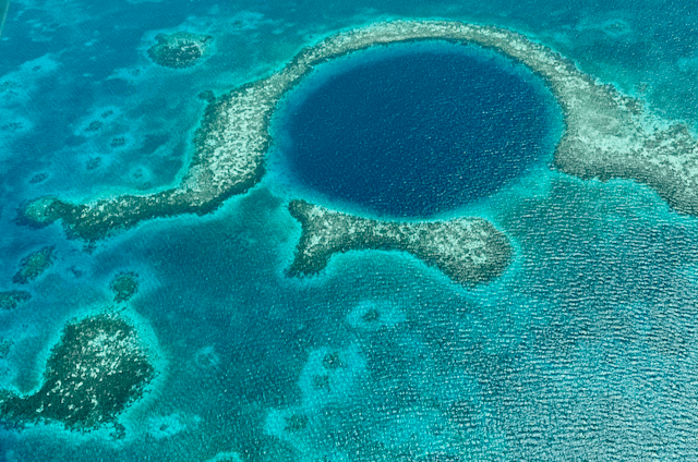
We’d scheduled two activities while in Caye Caulker. First was overflying the Blue Hole. This is a legendary scuba destination, but since we don’t dive, a flight was the next best thing. There are two primary tour operators who provide flights from the small Caye Caulker airstrip: Tropic Air and Maya Air. Both operate air service to the mainland and other islands with Cessna Caravans, but only Tropic has Caravan flights over the Blue Hole.
A TropicAir Caravan on its way
The TropicAir website is absolutely awful, so save yourself some hassle and call them if you want to book a flight. The flight takes about an hour overall. Tropic Air has a very nice new terminal building at the airport; after a brief wait, the C208 landed and we joined the passengers who had already flown from San Pedro to pick us up then departed for the tour. The flight out was at 3500′, then we descended to 1000′ over the Blue Hole, and went as low as 700′ to see the shipwreck. Whether or not you enjoy flying in small airplanes, the scenery is absolutely stunning; watching the pilot and silently judging his airmanship was just an added bonus for me.
aerial view of the Blue Hole
note sadness on my face because I am not the one flying the plane
most shipwrecks are underwater… not here
Because we are who we are, of course we had some unscheduled activities while at Caulker, too, including taking one of the Colinda kayaks out for a paddle. The wind was steady the whole time we were there: out of the east at 15 to 20 knots. This made kayaking a little more difficult than it would have been if we’d gone to the west side, but being able to take a few steps from our cabana and be in the kayak made up for that.
we should be keeping a list of “places we have been kayaing”
Our other big adventure was snorkeling. Caye Caulker sits about a 5-minute boat ride away from the edge of a large reef system and marine preserve, so we were eager to get out in it and snorkel. Caveman is the best-rated tour operator on the island but they wouldn’t return Erica’s emails, so we booked with Anwar Tours and had a superb experience. Our guide, Jian, was born on the island and has lived there his entire life, so he was a wealth of information and guidance about the area. At the first stop, we fed rays and nurse sharks; the other two were actually inside the reef boundaries, so we got to see a gorgeous selection of marine life, including the biggest, ugliest moray eel I’ve ever seen.
A few other Culker highlights:
The coffee at Ice and Beans is terrific. We made it a regular morning stop.
There’s a local food called “fryjacks”. Think of it like a super-sized empanada– a fry-bread shell stuffed with goodies. Errolyn’s was our favorite fryjack place, but we had good ones at Ka’ana and at a couple of other places.
The local animal shelter lets their charges run around the island during the day. You will often find friendly dogs, and occasionally cats, just walking around spreading joy.
One morning we did a yoga class at Namaste. It was jam-packed, but it was a good class.
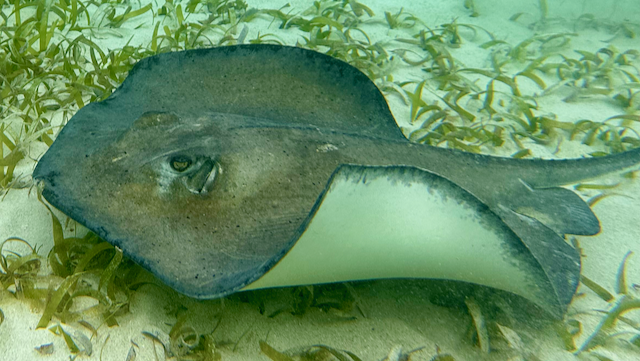
Every day at sunset, the staff at the Iguana Reef Hotel feeds the stingrays, which means you can get as close to them as you want.
If you can’t find a dog to pet, a stingray will do
Although I would happily have stayed longer, eventually we had to go back home. Sad, right? On a whim, I decided to book us on Maya Air for the 8-minute flight back to the Belize City airport. The small price premium (compared to buying water taxi tickets plus a taxi from the ferry to the airport) was far outweighed by the time savings, and buying the ticket could not have been easier– show up at the Maya Air counter, tell them your name, hand them a credit card, and walk away 5 minutes later. It was faster to buy these tickets in person than it usually is to buy tickets from the websites that American or Delta offer.
Our view on departure– Colinda is the third dock from the bottom
Anyway: as advertised, the flight was about 8 minutes long, then we were on the ramp at BZE. Customs and immigration was again straightforward, and after a short wait we were back on another 737-800 headed home.
Overall, Belize was an amazing place to visit and I’m eager to go back.
This post should have been titled “Bermuda 2021” but hey, what can you do?
Back in ancient times, Erica found a race called the Bermuda Triangle Challenge that looked like fun, so we signed up for it with the intent to run it in 2021. I booked a hotel, got plane tickets, and then… it was postponed twice because of COVID. We finally made it there to run it this year, thus this trip report.
The first challenge: getting there
The BTC is a three-race series: a one-mile race down Front Street on Friday night, a 10K around the island on Saturday morning, and either a half- or full marathon Sunday morning. As the race weekend fell over the Martin Luther King Day holiday weekend, we decided to arrive Thursday and come back Monday.
Sad fact: there is no 100LL aviation gasoline to be had in Bermuda, so I couldn’t fly us there. Carmen carries 136 gallons of usable fuel, which equates to about 5 hours of flying time, less a one-hour reserve. I could get us to Bermuda easily, but I wouldn’t have enough fuel to get back. That meant we were going to have to take a commercial flight, and that turned out to be surprisingly difficult to schedule. We ended up flying HSV-ATL-BDA on Delta on the way out and then BDA-JFK-DCA-HSV on American for the return, both booked with frequent-flyer miles. The routings were weird because of seat availability, but the timing worked out OK.
The race organizers had designated the Hamilton Princess as the official hotel, so originally that’s what I’d booked us into. Tourists are generally not able to book rental cars, and so I wanted to minimize the amount of travel required for packet pickup etc. I had paid a deposit equal to the room charge for 4 nights when originally booking, and the hotel agreed to apply the full amount to the 2023 race weekend, so we were all set.
Day 1: arrival, lighthouse, and fish
After a completely uneventful flight, we arrived at the Bermuda airport to a lovely sunny afternoon. Bermuda is long and narrow, and there are really 3 major roads: the North Shore Road, the South Road, and (wait for it) the Middle Road. The airport is on the northeast corner of the island, and our hotel (and downtown) are right under the “H” in the word “Hamilton” in the map below. I had pre-booked airport transfers with CEO Transport, so our driver met us at baggage claim and off we went. Taxis are plentiful, and the drivers all have to pass a London-style exam on island geography and street names before they get licensed, but they only take cash. There’s no Uber or Lyft, but there’s a local app called Hitch that serves the same purpose.
thanks to Apple Maps for this view of the islands (Bermuda is a bunch of islands, not just one)
After about a 20-minute drive, we arrived at the hotel and found our room ready. They’d unexpectedly upgraded us to a room with a water view– I say “unexpectedly” because they had tried several times to sell me expensive pre-arrival upgrades. When I say “expensive,” I mean “the upgrade was 1.5x to 7x the actual room rate”, so I certainly didn’t expect to get anything for free. We dropped our bags, let our phones charge for a few minutes, and then set out for our first excursion, to the Gibbs Hill lighthouse. (Notice that I didn’t say anything about “lunch” yet…)
The lighthouse is about a $30 taxi ride from the hotel. (Bermuda uses the Bermudan dollar, which is tied 1:1 to the US dollar, and every place we went accepted either or both.) The lighthouse itself is pretty spectacular– it’s made of cast-iron panels bolted together and was only the second of its kind in the world when it was built. There’s a small gift shop that sells tickets for $4, with which you can climb to the top. Note that the lighthouse itself closes at 4pm– lots of things in Bermuda close early, and this was our first introduction to that concept. We climbed to the top using the 180+ narrow spiral steps inside the lighthouse casing, where I shot this panorama:
I like the way the curved railings turned out in this photo.
The views over the island are pretty spectacular too. The camera doesn’t really capture the zillion shades of bright paint used on the houses, but you can see that all the rooftops are white. That’s because Bermuda doesn’t really have much of a water system. Most houses have cisterns that catch rainwater from the roof– the roofs are terraced to improve the catch rate then painted with lime, both as a means of purifying the rainwater but also for temperature control.
Not a bad view
The lighthouse itself is still operational, and it also has a surface-search radar (which you can see at the very top). The nearby grounds are pretty small so the whole visit couldn’t have taken more than half an hour or so.
There’s just no way to take a lighthouse picture that doesn’t look phallic.
By this point we were both super hungry, and there’s a small Indian restaurant on the lighthouse grounds… but it didn’t open until later, so we had our driver drop us at a restaurant we’d seen on the way to the lighthouse called “Lost in the Triangle” (or LITT). We shared an order of fried wahoo bites (think “fish nuggets”) and then both had fish tacos, which were excellent. Dinner for two, with 2 beers and 1 mixed drink, was about $110. It turns out Bermuda is pretty expensive– you should expect to pay $10 or so for a beer, $15-20 for a mixed drink, and $25+ for an entree at most local restaurants. Restaurants typically add a 17% gratuity, too.
After dinner, we started walking back to the hotel. Fun fact: Hamilton has lots of streets with no shoulders or sidewalks, and some of them have retaining walls or hedges that come right up to the edge of the road. Walking thus turned into a game of dodge-the-car more than we wanted to, so after darkness fell we stopped off at Crow Road Park and got a taxi back to the hotel. And so to bed.
Day 2: kayaking and the Butterfield Mile
Friday was our first “race day” but we didn’t really have much scheduled in the morning. We went to Devil’s Isle for breakfast and coffee, and it was excellent. They have a great selection of dishes, including huevos rancheros and a bunch of gluten- and/or dairy-free foods. The coffee was quite good. How did the restaurant get its name? Fun question.
Brief history lesson: Bermuda is named after Juan de Bermudez, who accidentally found it by wrecking his ship there. The Spaniards left as quickly as they could because they thought the island was populated with devils– the Bermuda petrel (or “cahow”) makes a loud screeching noise, and that plus the noise of previously-shipwrecked wild hogs scared them enough that neither Spain nor Portugal settled the island. Made of sterner stuff, the British did settle it after a 1609 shipwreck. The shipwreck victims refused to leave (since they were supposed to go to Jamestown and had heard conditions there were bad), so the British Crown claimed the island and turned it into a prison colony.
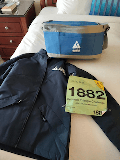
Anyway. Breakfast was delicious. Our next item was to go pick up our race packets. Somehow our registration had been lost in the shuffle due to the double deferment, but the registration team got us sorted out reasonably quickly. The race swag is terrific: a small folding cooler bag, a really nice heavyweight jacket, and a short-sleeve race tech shirt.
You can’t tell from the picture, but the jacket is probably 1/2″ thick and quite warm
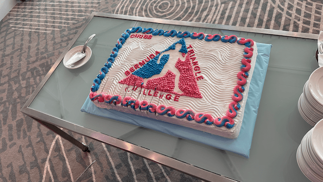
The rest of the race expo was pretty unremarkable, except for the excellent locally-made rum cake shown below. As you might expect, it didn’t last very long.
We stashed our stuff back in the room and headed to the pool. The hotel has a lovely large infinity pool and a good-sized hot tub, both with great ocean views, plus a smaller adults-only pool off to one side. We spent a couple of very pleasant hours sitting in the sun and reading; it was a little cool for being in the water, but not bad at all. The big issue was the wind– a steady 15-20kt wind coming from the south led to a note from the hotel telling us they’d be putting all patio furniture in the room overnight to keep it from blowing away. (Several of our taxi drivers said “every year the weather is terrible at race weekend!” so this is a known issue).
Note the edge of the infinity pool.
For the afternoon we’d booked a glass-bottom kayak tour at Robinson’s Marina. We told our cab driver that we wanted to get lunch on the way– did he know a good place to get a fish sandwich? Turns out he did. Check this beauty out:
I would cheerfully eat one of these every day for the rest of my life.
Seaside Cafe provided the above behemoth: about half a pound of fried wahoo served on fresh, thick-cut raisin bread. This is a local delicacy that I was eager to try and it was SO GOOD, y’all. I happily ate every bite and it was well worth the $17 price.
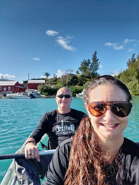
Our guide was terrific– he grew up a short distance from the marina and knew the local area very well. We saw one large sea turtle, a few parrotfish, and a good variety of seabirds (mostly herons and gulls). Partway through we stopped at the Morgans Island Nature Reserve for a beach break. Because we mostly stayed in the harbor, even though the wind had picked up a good bit the paddling was completely manageable.
The harbor area is pretty shallow– at its deepest it’s maybe 10′– and the visibility was superb. The pictures don’t really do justice to the clarity and color of the water. Interestingly, there’s not a lot of grass on the bottom in the shallows, as you might expect.
The columns above are characteristic of limestone– the water erodes them over time. Our guide, who was in his late 20s by my guess, said they had noticeably eroded since his boyhood nearby, which isn’t really surprising. One thing he said that did surprise me was that rent for a one-bedroom apartment could be as high as $5000/month! A later perusal of apartment rental listings confirmed that. Ouch.
After kayaking, we decided to stop at Horseshoe Bay. We’d seen it several times while driving by; it’s well-known as one of the most popular beaches in Bermuda, and even though it was too cool and much too windy to swim, we still wanted to see it. The beach was mostly empty except for a gang of kite surfers and a few other beach-walkers. In the summer, it’s apparently crowded, and the facilities (including a snack bar) are open. Today, not so much. After a few photos, during which I manfully resisted the temptation to climb on the cliffs that had big signs saying “danger! do not climb these!” we headed back to the hotel to prep for the race.
Those kite surfers were flying
the beautiful Erica in her natural habitat
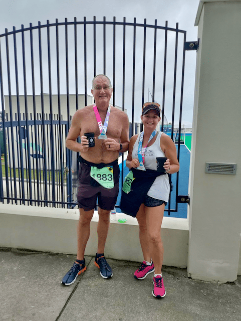
So, that first race. We had both previously agreed that the point of this challenge for us was “go home uninjured”– neither of us was adequately trained, and racing a 1-mile race sounded like a good way to get hurt. The race is a short loop on Front Street, the main drag in Hamilton. There was a good crowd of several hundred runners, including a large contingent of school-age kids and some elite milers who were there chasing prize money. We had a nice jaunt out and back, nothing too speedy, and collected the first of our four Challenge medals. Then it was time for a quick shower before dinner at the Mad Hatters. The food was superb, as was the company, but the service was a bit slow.
Brief digression: Bermuda is a really interesting hybrid of what Americans think of as “island time” and British-ness. Cars drive on the left, houses and buildings have names (“Waterloo House”) instead of just street numbers, there are frequent references to kings and queens, and so on. The pace of life seems quite a bit slower than in the US, but not as relaxed as the Bahamas or Jamaica. Nearly everything’s closed on Sundays, and many businesses close at 4 or 5pm during the week. Restaurants aren’t open late (e.g. Mad Hatters closed at 9pm), and there’s not much in the way of night life. Bermuda is not where you want to go if you want a Mallorca-style party atmosphere.
Day 3: the 10K and stormy weather
The Saturday forecast called for the weather to steadily worsen. When we went to bed Friday night, I half expected to wake up to a text saying the 10K had been postponed. When we woke up, however, it was only raining intermittently, and there was a steady brisk wind but it wasn’t terrible. We got up, had in-room coffee, and headed downstairs to catch the shuttle. The 10K started from the National Sports Centre, which was nowhere near walking distance from the hotel. After a quick shuttle ride, we arrived at the venue and wandered around, including doing a few warmup laps around their track, then it was off for the 10K.
The race course was quite scenic– we left the stadium, ran on Middle Road for a while, and then got onto North Shore until we approached the sports centre again. We stopped for a couple of photo opportunities, as one does. The wind was steady, and it was warm (maybe 70º) and quite humid. We’d both started the race with long-sleeved tech shirts on, but I shed mine about halfway through.
A scenic selfie stop along the 10K route
The race finishes on the running track at the sports centre, which was neat. We got our second medal and then enjoyed the post-race festival for a bit; the organizers had a hot dog cart, a table with four kinds of draft beer from one of Bermuda’s two local craft breweries, and a bar serving rum drinks made with Gosling’s, plus a few other assorted snacks.
Two medals earned, two to go
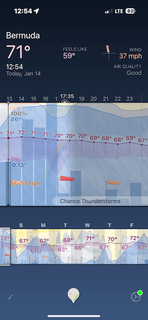
We went back to the hotel to clean up, had a snack at the hotel coffee bar, and got ready to meet our tour guide. Meanwhile, though, the weather was steadily worsening. I wish I’d taken a picture of the radar view– but one interesting nuance of Bermuda is that there are some gaps in offshore radar coverage because of where Cuban and Bermudan radar coverage sits. That sometimes makes storms appear out of nowhere (from a radar perspective; they’re visible on satellite).
The weather as we started our tour was… not great
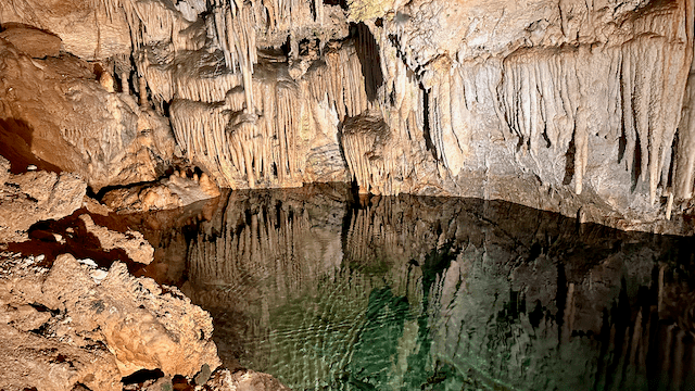
Erica had found a local tour guide and taxi driver named Carol who is apparently locally famous for her knowledge and personality. She was terrific. We spent about four hours with her driving all over the island, all the way up to St Georges at the north end. As a retired policewoman, she had a lot of offbeat local knowledge and was overall just a pleasant and wonderful companion. The weather kept us from seeing some of the landmarks in detail; for example, we couldn’t drive up to Fort Hamilton because the roads were closed. We did get to visit Crystal Cave, which was originally discovered by two teenage boys who were chasing a lost cricket ball.
A view inside Crystal Cave
During the last hour of the tour the weather improved briefly, just long enough to get us back to the hotel, but as it was forecast to worsen again, we decided to try the hotel’s room service. It was pretty decent, although their fish sandwich wasn’t nearly as good as the one from Seaside.
Day 4: the half-marathon
By the time we got up Sunday morning, most of the weather had passed– it was still cloudy and breezy (and warm!) but not stormy. The start line for the race was actually at the end of the hotel’s driveway, so we didn’t have much of a commute. The RD asked runners to gather about 1/3mi down the road, where the finish festival would be located, so we wandered down there for a pre-race picture and some gentle warmups.
Excited to take my work running shirt for its first outing
The last half-marathon we ran together was Tear Drop in 2021, and because our training volume was low, we’d agreed to just treat this as a long extended photo opportunity and not a race per se. After the starting horn, we got out on the course and enjoyed seeing some of the same areas we’d already seen, plus some new territory, including a photobomb by St Mark’s Church.
The race was well-supported, with several hydration stops, on-course entertainment from (at least) 3 bands, and two stops serving Gosling’s rum drinks. There were a surprising number of spectators, too, even in the residential areas, and nearly every single one of them would shout, wave, or otherwise signal their support. That’s such a nice change from the races I’m used to, where on most of the course there’s no one but the runners; we really enjoyed that aspect of all 3 races.
It’s hard to overstate how refreshing my Dark and Stormy was at this point
The weather steadily improved; it got warmer and sunnier the longer we were on the course. (This improvement was deceptive; more on that in a bit.) At the finish festival, we feasted on hot docs, Haagen-Dazs, and local pastries, then headed back to the hotel for some hot tub time.
mission accomplished!
Not surprisingly, the hot tub was jammed with other runners, so we socialized for a little while, then tried to sunbathe. This was frustrated by the unwanted arrival of more rain, so we decided to wait it out in the room and then do a self-guided walking tour of Hamilton. We walked through the cathedral, saw the outside of the parliament and supreme court buildings, got rained on a bunch, and made the short climb up to Fort Hamilton just before they closed. The view was well worth the excursion, especially the beautiful garden area at ground level between the inner and outer walls. (Sadly I didn’t take any pictures of this!)
looking back to the northwest from Ft Hamilton
We did dinner twice, sort of– we’d made reservations at Hog Penny for dinner, but were both famished, so we stopped off and had some excellent nachos and a beer flight to tide us over at the Pickled Onion. As it turns out, two dinners is just slightly more than the recommended amount of food, even after a half-marathon, but I certainly don’t have any complaints. Hog Penny, which opened in 1957 and is Bermuda’s oldest restaurant, had a trivia contest going while we were there, which added a festive note to our excellent pub food-style dinner. I had an excellent shepherd’s pie, Erica had fish and chips, and we split a sticky toffee pudding for dessert. Good stuff.
Day 5: the trip home
Travel home was uneventful. The best part was probably the spectacularly large rainbow we saw on the drive back to the airport. Our American flight BDA-JFK was delayed about an hour, but that delay didn’t keep us from getting home on time.
We didn’t get as much beach time as I would have liked because the weather was uncooperative, and there were several local landmarks and activities that we didn’t have time for because we built our visit around the race schedule. It’s a lovely island, with a relaxed and friendly population, and I’d like to go back.
First, a brief commercial. You can get a free browser plug-in called “Library Extension” that is pure magic: any time you load a book’s page on Amazon.com, the extension will show you if your local library has it in its collection, and then let you place a hold on it with a click or two. This has absolutely increased my reading rate while simultaneously saving me money.
This year I didn’t read as much non-fiction as I have in some past years, and, of what I did read, most of it was solidly average. This year featured four standouts:
Extra Life: a marvelous recounting of the history of life extension, wandering off along the way into epidemiology, statistics, actuarial science, and a variety of other goodies. Captivating.
Running the Dream: suppose, as an amateur runner, you put your normal life on hold and went to train with elite professional runners. How much could you improve? Funny, moving, and motivating, all at the same time.
Bonk: the delightful Mary Roach, our national literary treasure, turns her wit to the topic of human sexual behavior. Five stars. Anything else I say would be a spoiler.
Full Spectrum: you might not think a book about the science of color would be that interesting, but Adam Rogers has tied together color theory, physics, chemistry, optics, archaeology, economics, and history to tell the story of how humans perceive color and what influence that’s had over the centuries on commerce, art, science, and society.
Now, on to fiction. This year (so far, anyway), I read 128 works of fiction. Some were disappointing (Stross’ Dead Lies Dreaming, Burke’s Every Cloak Rolled in Blood); others were good, but not exceptional. This year’s best from my POV:
Damascus Station: a tense, taut, tradecraft-y thriller from a former CIA case officer, set in the unfamiliar territory of modern-day Damascus. A standout choice because of its plotting and tension.
American War: vividly imagined tale of a future America after the second Civil War. It is simultaneously exactly what you’d expect (north vs south, anyone?) and nothing like you’d expect.
How Lucky: like Hitchcock’s Rear Window, but set in Athens, Georgia — a wheelchair-bound man sees something that might be evidence of a crime and chaos ensues. Booklist said “beautifully written and suspenseful, at the same time being all about goodness and caring without once being sappy, or, well, sentimental,” and I can’t improve on that description at all.
The Deep Blue Good-By: why, oh, why, hadn’t I read any of the Travis McGee books before?!
The Oracle Year: imagine that you woke up one day with foreknowledge of the future, but it’s things like “the bodega on 34th Street will be robbed on June 9th”. What would you do? Probably not what the characters in this book did. Very cleverly plotted, with terrific and memorable characters.
Termination Shock: finally, a Neal Stephenson book where he returns to his old form. After his last couple of stinkers, it’s nice to know he hasn’t completely crossed the Heinlein-Clancy line, or the point in an author’s career in which commercial success leads to the mistaken belief that editors are superfluous.
The Fifth Season: it took me a while to warm up to this book, but the more I read, the more engrossed I was with the characters and the world that Jemisin has built. I’m looking forward to the other books in the series.
Cold Water: the next installment in the fantastic “Fractured Europe” sequence that started with Europe in Autumn. I went back and re-read the first 4 books in the series and was delighted with how much more I enjoyed them after a decade of travel throughout Europe; my expanded experience added a lot of flavor.
Amok: the latest installment from Barry Eisler goes back to the early 1990s to provide a back-story for Dox, one of my favorite characters in his other books. It is at once an origin story, a meditation on forgiveness and growth, an exploration of the Indonesian civil war, a travelogue, and a love story. It’s been a real pleasure to see Eisler’s characters grow and evolve, along with his storytelling skill, over the years.
Noble House: 1300+ pages of soap opera set in 1963 Hong Kong. This book was perhaps the best I read this year from a standpoint of evoking a sense of time and place as I read it. Michener and Clavell (and maybe Wouk) practically invented the 1970s genre of “massive doorstops of historical fiction” and this is probably the ultimate example of the genre.
I’ve already got quite a backlist for 2023, so expect to see another list around this time next year!
A couple of weeks ago I dropped Carmen off at the airplane doctor for an annual inspection. “What’s that?” said no one. Well, I’ll tell you what it is, since you didn’t ask…
The FAA requires regular inspections of most airplanes. That sounds vague, but the truth is that the requirement varies according to what the airplane is used for, whether it’s an experimental or amateur-built (E/AB) airplane, and so on. For my purposes the FAA regulation that applies is FAR 91.409:
…no person may operate an aircraft unless, within the preceding 12 calendar months, it has had (1) An annual inspection in accordance with part 43 of this chapter and has been approved for return to service by a person authorized by § 43.7 of this chapter
That seems straightforward enough. Back in February, I hired a mechanic in California to perform what’s commonly called a “pre-purchase inspection”, and then I had the excellent experience of taking Carmen to one of the service clinics sponsored by the American Bonanza Society, where master mechanic Wayne Whittington did a very thorough checkout using the ABS clinc checklist. However, neither of these are considered to be an “inspection in accordance with part 43,” as the FAA says above.
FAR part 43 annual inspections are required every 12 calendar months; the last one on this plane was done 4 November 2021, so a new one is required before 30 November 2022– you get until the end of the month when the last annual was signed off. It’s bad to let a plane go “out of annual,” because legally it is considered unairworthy and can’t be flown without a special permit at that point. It’s easier and cheaper just to make sure that doesn’t happen.
One part of the annual ritual of inspection prep is to make a comprehensive list of all the things you might want to have the mechanic inspect, fix, or change. This is just a starting point, because more often than not a thorough inspection by a trained professional will find things that the pilot’s missed. Here’s the list I gave to Jon, with my notes to you in italics:
Annual inspection per the Beech maintenance manual (this manual is what FAR part 43 says you have to use to make the annual legal)
3 common items that seem to have been done each preceding annual. (I didn’t check to see if these were in the manual or not)
Check and service unfeathering accumulators (these accumulators are small tanks of nitrogen that apply pressure on demand to push the propeller out of its “feathered” position)
Check and service shimmy dampener (think of this dampener like a horizontal shock absorber mounted on the nose gear to keep it from wobbling)
Borescope inspection of all cylinders
Compression test of all cylinders. (If any are low, we’ll talk about whether to replace the cylinder or try another way to fix the underlying problem, depending on whether it’s the rings, the intake valve, or the exhaust valve)
Fix a small crack in the skin of left aileron. (Although this sounds scary, it’s not; the crack is in a little piece of cosmetic metal that sits over a bracket to hide it, not part of the structure of the aileron)
Replace the instrument air filter (this filter keeps crap from the carbon vanes of the vacuum pump from getting into the vacuum-driven flight instruments)
Verify compliance with AD 2007-08-08 and AD 91-17-01 (more on this below)
Oil change both engines
Replace main tires
Service brakes, using new pads; replace discs if necessary
Replace fuel cap O-rings (each fuel cap has two O-rings to help seal it, and these wear out over time)
Install fluorosilicone washers on 2 main tank fuel caps
Check front seat inertial reels; fix if needed (the pilot side seems awfully slack)
Fix socket/bulb/wiring of leftmost glareshield panel light
Fix “hitch” in electric trim in “Down” mode—it is binding or hanging. “Up” mode works OK, manual trim in both directions works ok.
A good mechanic will help you identify things that are legitimate airworthiness or safety issues and prioritize those. In the above list, probably the most safety-critical item is the seat belt reels– the accumulators, dampener, oil change, air filter, and so on all need to be done eventually. I’m thankful that the prior owners maintained Carmen to such a high standard so there aren’t any known lurking horrors– but Jon may find some, which is the whole point of doing annual inspections.
One key part of the annual is that the mechanic will verify compliance with airworthiness directives, or ADs. These are important maintenance actions that must be complied with– for example, AD 2007-08-08 requires periodic inspection of a part that locks the landing gear in the “up” position to ensure that it will work properly when needed. This inspection must be done every 100 hours; there are other ADs that must be performed periodically, so Jon will check all of the ADs that apply to this plane (and its engines, and propellers) and make sure that they’re complied with.
I also decided to have the propellers overhauled. The manufacturer recommends that these particular props be overhauled every 6 years or 2400 hours. These props were installed in 2008 and have close to 2400 hours on them, so it’s time– but, as with engines, the “time between overhaul” (TBO) is a recommendation– for ordinary general aviation operations under part 91, owners aren’t required to observe that TBO. It’s legal for me to keep flying engines and propellers as far past TBO as I want to. With engines, you can do compression checks, borescope inspections, and oil analysis to get a good idea of the engine’s health– but with propellers, you can only see the visible parts of the prop, and that’s it. There’s no good way to non-destructively inspect the propeller’s components, other than the blades. That’s because the propeller hub isn’t visible when the propeller’s mounted, not to mention that it contains a bunch of seals, springs, and other parts. That’s because this plane uses constant-speed propellers, where the propeller governor changes the blade pitch so that the propeller maintains the commanded RPM even as the engine power changes. (For more on how constant-speed propellers work, this explainer is pretty good). With all that in mind, I decided to go ahead and have the props overhauled since the plane would be down The overhaul process can take a while– the shop I chose, First Flight Propellers in Mississippi, is currently estimating about 4 weeks. This seems like a long time, but the overhaul process is quite involved, plus once the overhaul’s done I’m good for another 6+ years.
Once the propellers have been overhauled, Jon will reinstall them, run the engines for a leak check and general test, Then I’ll pick the plane up when the weather is good and do a test flight of at least 30 minutes, staying in the vicinity of the airport just in case something is amiss. Assuming that goes well, I’ll fly Carmen back to the hangar and enjoy another year of being in compliance with 91.409. I’m looking forward to it!
As I was working on another post, it dawned on me that I hadn’t finished the story of why I didn’t fly to the Bahamas. As you might recall, in that post I talked about how the ABS service clinic found an anomaly in the cylinder, one that my local mechanic thought was no big deal. To be cautious, I sent the cylinder back to Superior for them to look at it. Then I promptly forgot about it, because I was busy flying to Asheville, Dallas, New Orleans, Atlanta, Auburn, Memphis, and Augusta before I bothered to ask Superior for an update. Turns out the cylinder lining was in fact cracked, but on the inside where the crack wasn’t visible. My precautionary cylinder change turned out to be a necessity, one which saved me the potential for an unpleasant in-flight event and a bunch of additional costs driven by one bad cylinder trying to turn the whole engine into junk.
I noticed that after the cylinder repair, the right engine was leaking small amounts of oil. North Alabama Aviation couldn’t be bothered to try to fix it, so I had Revolution Flight take a look and they identified it as an upside-down gasket installed on the rocker arm cover. This is exactly the kind of small but infuriating maintenance error that every pilot has to learn to deal with. While I could have flown the plane over to Decatur and stormed into the shop to demand that they fix it, I decided instead to write this short note to memorialize their poor performance (along with the ridiculously long time it took them to do the repair in the first place) in hope that future generations will see it when they’re shopping for a maintenance shop.
Back to cylinders. For many engine types, having a cylinder replaced is super common. For example, the large turbocharged TIO-540 used in many models of the Piper Malibu is notorious for requiring frequent cylinder changes because of the operating conditions: the engine’s crammed into a small space with marginal cooling, then operated at high altitudes where turbocharging is used, which increases the heat and pressure regime that the cylinders run under. It’s less common to have to replace them on the normally-aspirated IO-470 engines that my Baron uses, but it’s not uncommon. So far, since the two engines were installed, there have been 3 cylinder changes (out of 12 cylinders total): this cracked one in 2022 and two others back in 2013 or so due to low engine compression. That’s not too bad.
Maybe that’s a good topic for a future post: why cylinders get low compression in the first place, and what you can do about it. Hold that thought…
I lived in the Bay Area for about five years. Among the many weird things I experienced there, one that particularly sticks with me is the way people acted when we got a thunderstorm. They’re quite rare in that part of the country and the arrival of even faint thunder was considered quite an event.
Of course, here in the southeastern US, thunderstorms are as common as pickup trucks, especially in the spring and summer. As I write this, here’s what the airspace near me looks like. When I look out my window, there are plenty of building cumulus clouds, but the real action is off towards Chattanooga.
It’s not necessarily intrinsically harmful to fly into, through, or under falling rain or snow. (Hail isn’t great, though!) However, when rain falls, it displaces air, and the result is that you get updrafts and downdrafts. Those can be harmful. In fact, the common rule of thumb is to avoid flying within 20 nautical miles of the boundary of a thunderstorm (like the one just northeast of the PRONE intersection above). That’s because, in the FAA’s words, “All thunderstorms have conditions that are a hazard to aviation. These hazards occur in numerous combinations. While not every thunderstorm contains all hazards, it is not possible to visually determine which hazards a thunderstorm contains.”
Notice that I was careful to use the word “thunderstorm” and not “rainstorm” or “rain cloud” in the preceding paragraph. That’s the crux of the problem: your eyeball alone can’t tell the difference. Thankfully, we have radar, which is where the image above comes from. There’s lots to say about modern weather radar, and all the modes and capabilities it has, but the best way to think about it from an aviation perspective is that it can show you two important things: is there precipitation in the area you’re going towards, and what are the winds doing?
If you shoot a beam of radar energy into a cloud, some will be absorbed, some will scatter off in various directions, and some will be reflected back to the receiving antenna. By magic, it’s possible to figure out quite a few things about a storm cell based on this reflection and a few other parameters, like the tilt of the antenna. For example, if you look at the Doppler shift of the returned reflections, that tells you something about the relative movement of air and water masses in the beam, which you can use to figure out which way the storm’s moving and, oh yeah, if it is showing signs consistent with the formation of tornadoes.
Anyway, enough about that. What I wanted to talk about today is something radar can’t tell you.
Before I get into that, though, I should spill a dirty little secret. Most of us don’t even have radar in our planes. The FAA broadcasts radar images through a ground-to-air datalink system known as FIS-B. This is worlds better than not having any radar imagery in the cockpit, but it’s super important to know that it’s not a real-time picture. FIS-B datalink images can be up to 15 minutes delayed, which means that they show you where the weather was. That means that what you see out the window is king, not what your FIS-B receiver shows. This is extra true because what the FIS-B radar shows you is a composite picture that tells you there’s precipitation (and if so, roughly how much). It doesn’t tell you at what altitude the cloud based or tops are, how much precipitation is reaching the ground, or much else of use.
With these limitations in mind, you can’t depend on ground-based weather data to distinguish between a rain shower and a giant thunderstorm, the more so because that ground-based data won’t show you where there’s lightning.
In the image above, you can see little blue lightning icons. Each one indicates a lightning strike picked up by what is basically a bare-bones radio receiver– lightning strikes make a hell of a lot of radio-frequency noise (as any AM radio listener can tell you). This noise is in the form of radio waves called sferics. With the right receiver you can pick those sferics up and triangulate their source– even better, you can do that in flight and get accurate, instantaneous real-time lightning data.
Why do you need to know where the lightning is? Because that’s where the thunderstorms are. Thunderstorms can have lightning (duh), extreme turbulence, hail, wind shear, and/or icing– and the only one of these that is easily detected from a distance is lightning. So it’s a pretty good proxy: you won’t ever see lightning if there’s no thunderstorm.
The picture above shows a live display from a recent flight I took from Decatur to Auburn. Each one of those little crosses is a lightning strike. It doesn’t take a Ph.D. to figure out that the more little crosses there are in an area, the less you want to be there. This screen is from a BFGoodrich (yes, them) Stormscope, which is basically this small LCD screen, a small box with a primitive computer in it, and a small array of antennas inside a flat enclosure on the outside of the airplane. The antennas pick up sferics, the computer estimates distance and bearing, and the screen shows you a +. There are newer, fancier models than this– mine was made in 1991– but they all work essentially the same way. In this case, I get a real-time, 360° view of lightning activity at up to a 100-nautical-mile radius, which is pretty great.
Compare what you see on the Stormscope view above with what the FIS-B picture looked like, below. On the bottom display (which is set to “track up”– so that the airplane’s southerly track is towards the top of the display) you can see a bunch of awful-looking red and yellow. I took these pictures a few minutes apart, so they don’t line up precisely, but they’re close enough to get the point across.
Of course, the best solution would be to have real-time in-flight radar and lightning data and ground-based FIS-B. Why?
Radar shows you what’s in front of you now, with good resolution and detail
A Stormscope shows you whether is lightning (and therefore, thunderstorms) embedded in the clouds you see via eyeball or radar
FIS-B feeds can show you radar imagery from the area where you are (including beyond immediate radar range), or over all of the continental US, which is really handy when you want to look ahead towards your destination.
Remember that earlier I said lightning is a good proxy for the presence of thunderstorms. The absence of lightning doesn’t mean you’re good to go, though. You can still have a thunderstorm with no lightning. That’s why a Stormscope alone isn’t enough to keep you out of trouble.
I don’t yet have radar, although this airplane did at one time and still has a good-condition nose radome. Until I equip a radar (which, let’s be honest, probably won’t ever happen), having the Stormscope along makes it much easier to decipher what’s happening in those clouds so I can give them an appropriate berth.
Thunderstorms are a hell of a lot more fun to watch from the ground than to fly through.
I used to fly a lot– in February 2020, just before the Big You Know What, I got an email from Delta telling me that I had crossed the two-million-mile mark with them. I say this not to brag, but to frame a key need I have: effective calendar management around flights. My business travel is starting to pick up again, but the steady drumbeat of news stories and anecdotes about how awful commercial air travel is right now spurred me to mention a few tools and strategies I use for managing this kind of stuff.
First, let’s filter out what I’m not talking about: searching for and pricing flights, choosing a preferred set of travel vendors, etc. The choice of Delta-vs-American (Delta, duh), whether to change planes in Paris vs Amsterdam (Amsterdam, hands down), or whether it’s true that you get the lowest fares when booking on Tuesday (nope)– these are interesting topics for another time but there are also zillions of travel blogs and videos and so on that cover that stuff. Instead, I want to focus on a fundamental issue: how do I track and organize my calendar around travel.
I’ll start with TripIt, because I did start with TripIt. I’ve had it since 2008 and it is an incredibly useful tool for several purposes. First, it’s an all-in-one trip planner. By forwarding airline, train, ship, car, and hotel reservation confirmations to the service, it automatically assembles itineraries and then gives me a simple interface, on web, mobile, and Apple Watch, to show me where I’m going and when, and how much layover time I have at each segment. Here’s an example for a recent trip from Huntsville to Kraków to London to Huntsville.
TripIt gives an easy-to-read summary of all aspects of a trip
The basic service is free, but I happily pay $49/year to get the “pro” feature set. This includes push notifications of airport gate changes, flight time changes (both for delays and advances), and a service that will alert you when a purchased airfare drops so you can get it reticketed and recover the difference.
TripIt also has the very useful feature that you can easily share your trips. When I have business travel, it’s easy to share the trip with Erica so she can see my itinerary. Better still, when we’re traveling together, we can both update and edit the itinerary– so while I’m booking flights, cars, and hotels, she can be planning, booking, and adding tours and other activities. Then we both have a complete up-to-date map and timeline of our travel, which we both love.
Then there’s Flighty. This app is pretty much magical. Like Tripit, it tracks flights, and it can notify you of gate changes, delays, cancellations, and so on. In practice, I tend to get notifications from Flighty 5-10 minutes before Tripit. This may not sound like much, but a 5-minute head start on rebooking when your flight’s been suddenly cancelled can be huge.
Flighty can read flight data from TripIt and write it to my iPhone calendar (which in turn is synced with my Exchange Online mailbox). Boom! When I book a flight, it shows up on my calendar with the time zones and locations correct… which means my coworkers can see when I’m in flight, avoiding double-booking. When a flight’s delayed, Flighty’s smart enough to update the calendar on its own. Flighty also ingests FAA delay data, which in itself is super useful. The Flighty app is beautifully designed and their support team is very responsive to feedback.It’s well worth the yearly fee (which I think is $40).
Speaking of FAA delay data… there’s an app for that. Or at least a web site: https://nasstatus.faa.gov/. Lots of people don’t realize how much trouble can be caused by a few storms in inopportune places. Delays at major hubs (like Atlanta, Chicago, or JFK/Newark/LaGuardia) cascade really quickly across the rest of the system–so if there’s a ground stop for bad weather, or storms that reduce traffic flow, or pretty much any ATC-related issue, the delays will spread a lot faster and further than you might expect, often leading to stories in your favorite media outlet with headlines like “travel meltdown.” Although it doesn’t really relate to travel calendar management, I mention this because I usually take a quick look at this page a couple of times on the evening before and morning of my commercial flights. That gives me a sense of what might lie ahead. It’s also my go-to when I have friends or family traveling and I want to keep tabs on whether they are likely to get to their destination on time.
Maybe a future topic: why the Jacksonville Center ATC facility is the biggest single contributor to widespread delays! For now, I’m going to get busy doing the travel expense report I procrastinated to write this.